
NATIONAL WEATHER SERVICE
TORNADO WATCH 57 REMAINS VALID UNTIL MIDNIGHT CST TONIGHT FOR THE FOLLOWING AREAS IN ARKANSAS THIS WATCH INCLUDES 6 COUNTIES IN SOUTH CENTRAL ARKANSAS UNION, IN SOUTHWEST ARKANSAS COLUMBIA HEMPSTEAD HOWARD LAFAYETTE NEVADA, IN LOUISIANA THIS WATCH INCLUDES 11 PARISHES IN NORTH CENTRAL LOUISIANA LINCOLN UNION IN NORTHWEST LOUISIANA BIENVILLE BOSSIER CADDO CLAIBORNE DE SOTO NATCHITOCHES RED RIVER SABINE WEBSTER
The National Weather Service in Shreveport has issued a

* Severe Thunderstorm Warning for...
  Little River County in southwestern Arkansas...
  Hempstead County in southwestern Arkansas...
  Northern Miller County in southwestern Arkansas...
  Sevier County in southwestern Arkansas...
  Howard County in southwestern Arkansas...
  Central Bowie County in northeastern Texas...

* Until 1045 PM CST.

* At 943 PM CST, severe thunderstorms were located along a line
  extending from near De Queen to near Horatio to 6 miles west of
  Richmond to 6 miles south of New Boston, moving east at 45 mph.

  HAZARD...70 mph wind gusts and penny size hail.

  SOURCE...Radar indicated. Numerous trees and power lines have been
           downed with these storms across McCurtain County
           Oklahoma. Roof damage has been reported as well.

  IMPACT...Expect considerable tree damage. Damage is likely to
           mobile homes, roofs, and outbuildings.

* Locations impacted include...
  Texarkana, De Queen, Wake Village, Ashdown, Nashville, New Boston,
  Mineral Springs, Dierks, Horatio, Foreman, Umpire, Nash, Hooks,
  Redwater, Red Lick, Lockesburg, Wilton, Blevins, Tollette and
  Fulton.
A Moderate Risk (red) and an Enhanced Risk (orange) remains in place across the region for today and tonight. All modes of severe weather will be possible (tornadoes, hail, wind). Remember, NOW is the time to prepare, don't wait for warnings to be issued before taking action!

Severe weather is likely across the entire region Thursday afternoon, especially in the northwest half of the region, continuing into the overnight hours. The above graphic shows the different tornado, severe hail, and severe wind outlooks. Areas in the significant hatched area have the best chances to see strong EF2 or greater tornadoes, damaging winds of 70-80 mph and hail 2" in diameter or greater.
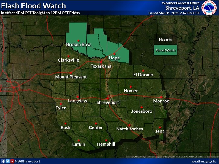
Areas of prolonged rainfall may result in flooding and flash flooding over the next few days. A Flash Flood Watch will go into effect at 6PM this evening, and remain in effect through Noon Friday.

A Wind Advisory will go into effect at noon today and continue through noon on Friday. South to southwest winds of 20 to 30 mph are expected with gusts up to 45 mph possible.

Weather radar at 8:45 pm Thursday
Go to weather.gov on the Internet for more information about the Tornado Watch and Flood Watch.
TORNADO WATCH 55 IS IN EFFECT UNTIL 1030 PM CST FOR THE FOLLOWING LOCATIONS IN ARKANSAS. COUNTIES INCLUDED ARE: LITTLE RIVER, MILLER, AND SEVIER
...FLOOD WATCH IS IN EFFECT FROM 6 PM CST THIS EVENING THROUGH FRIDAY MORNING... A widespread severe weather outbreak appears to be possible this afternoon and into the evening and overnight hours. There will be two main chances for severe weather. The first will come during the early or mid-afternoon hours when we have the potential for discrete supercells. This would pose a threat of large hail and strong tornadoes. The second round will come along just ahead of an advancing cold front that will push through during the late afternoon and into the evening and overnight hours. The main threat for this round will be damaging wind gusts and embedded tornadoes. In addition, moderate to heavy rainfall will be possible from training storms, increasing the potential for Flash Flooding.
Thunderstorms will become numerous this afternoon and continue into tonight, with widespread severe weather likely across much of the region. The greatest risk for severe weather will exist along and east of Highway 281 during the day, shifting east of the I-35 corridor during the evening hours. All modes of severe weather will be possible, including large hail, damaging wind gusts, and tornadoes.
ACCUWEATHER

Thunderstorms on Thursday will erupt from the afternoon into the nighttime hours from Texas through the Ark-La-Tex region and into the lower Mississippi Valley.
This will be the peak of the severe weather risk this week, with AccuWeather forecasters warning of a rare 'high risk' for severe thunderstorms across parts of northeastern Texas, southeastern Oklahoma, northern Louisiana and a large portion of Arkansas. This threat area includes the cities of Dallas, Little Rock, Arkansas, and Shreveport, Louisiana. Damaging hail, perhaps as large as golf or tennis balls, and a few powerful tornadoes will be possible.
Storm chasers, such as extreme meteorologist Reed Timmer, were gathering in the high-risk area early on Thursday, ahead of the expected formation of tornadoes late in the day.
A much wider part of the country, spanning more than a dozen states and extending from southern Texas to Kentucky, can also experience strong thunderstorms that also could produce damaging wind gusts that bring down trees and power lines, as well as flooding downpours that could imperil motorists.