
[WHAT] Severe weather and heavy rainfall
[WHEN] Late Tuesday night through Saturday night. ○ Severe weather threat late Tuesday night through Thursday. ○ Heavy rainfall and resulting flash/river flooding threat Wednesday through Saturday.
[WHERE] Most of the state will be at risk for severe weather as well as the heavy rainfall.

Severe Weather Outlook for Arkansas today
[WHAT] Strong to possibly a few severe thunderstorms are likely to impact Arkansas.
[WHEN] Today, Tuesday March 4, 2025.
[WHERE] Most of the state, but especially portions of central Arkansas, and all of southern Arkansas.
[ADDITIONAL INFO]
If the environment destabilizes enough, severe weather (including tornadoes) will become likely.
Gusty winds in excess of 40+ mph will be possible ahead of the thunderstorm activity and after the passage of the thunderstorm activity through Wednesday.
[KEEP IN MIND]
The early arrival of precipitation (this morning) may keep the atmosphere from becoming overly unstable. If rain arrives later, or progresses more slowly to the east, then destabilization will occur. This is very concerning given that available shear will be impressive (to promote tornadoes).
This will be the last severe weather briefing regarding the severe thunderstorms moving across the state today.

The most widespread hazard across Arkansas today will be the risk for damaging wind gusts. Damaging wind gusts will be possible statewide; however, southern portions of the state will see the highest potential for severe winds. (Note the hatched area across southern Arkansas which indicates a 10% or greater chance for significant severe winds equal to or greater than 74 mph.)
Winter Weather Briefing from the National Weather Service in Little Rock

[WHAT] Winter weather conditions, including accumulating snow, mixed sleet and snow, and some freezing rain is forecast to spread across the state today through Wednesday, resulting in widespread travel impacts.
[WHEN] Winter precipitation will begin across northwest Arkansas later this morning, and expand towards central to southern Arkansas by this afternoon to evening, and persist through Wednesday morning (February 19).
[WHERE] Significant accumulating snowfall is expected across the northern third of the state, with mixed precipitation including sleet/snow and freezing rain over the southern two-thirds of the state.
[ADDITIONAL INFO]
Winter Storm Warnings are in effect for portions of northern and central Arkansas due to heavy snow and sleet. This is where forecast confidence is highest for impactful accumulations.
Winter Weather Advisories are in effect for the remainder of the state where lesser snow, sleet, and freezing rain totals are expected.
Hazardous cold is forecast by Wednesday morning with single digit to negative morning wind chill values forecast through Friday morning. Cold Weather Advisories are in effect for a large portion of the state tonight, and additional cold weather headlines will likely be needed through Friday morning.
Severe Weather Outlook for Arkansas from the National Weather Service in Little Rock

A few strong to severe thunderstorms are possible across western Arkansas Wednesday evening and Wednesday night.
Scattered showers and thunderstorms will be possible today across the region into this evening. Late tonight, strong to severe thunderstorms will be possible mainly northwest of the region. Look for strong south winds today outside thunderstorms with wind gusts upwards of 30 mph possible. There will continue to be an elevated fire threat due to very dry conditions with those conditions continuing until rainfall materializes later today into Thursday.

A few strong to severe thunderstorms are possible across eastern and southern Arkansas Thursday.
In SW AR, rain chances will continue through the end of the work week, into the upcoming weekend and into early next week as well. At this time, strong to severe thunderstorms do not appear likely through early next week. Temperatures will remain mostly above normal through the extended period as well.

The forecast for Halloween evening calls for rain chances across the southeast with dry conditions elsewhere. Temperatures will largely be in the 50s and 60s.
Severe Weather Briefing from the National Weather Service
There will be a brief window for severe weather Monday afternoon and evening over the south and southeast parts of the state. While there will be a lot of wind energy with this system, instability is low which will keep the severe threat limited.
Windy conditions are expected to develop before the actual system arrives and some parts of the state may see some locally heavy rain.
We continue to monitor a strong cold front that will be moving across the state Monday into Monday evening. Sustained winds of 20 to 30 mph are expected with higher gusts possible outside of any thunderstorm activity.
Strong gusty winds remain the primary threat with storms on Monday. While the tornado threat is minimal, it is not zero.
The greatest overlap of severe thunderstorm ingredients will lie over southern and southeastern Arkansas Monday afternoon and evening. While there is a tremendous amount of wind energy with this system, instability is limited.
Widespread rain is expected before the actual cold front arrives which will further decrease the chance of widespread severe weather.
In addition to severe weather, localized heavy rainfall is possible, primarily over the western half of the state. Some localized flash flooding issues may arise as a result.

Severe weather expected in Arkansas Thursday and Friday
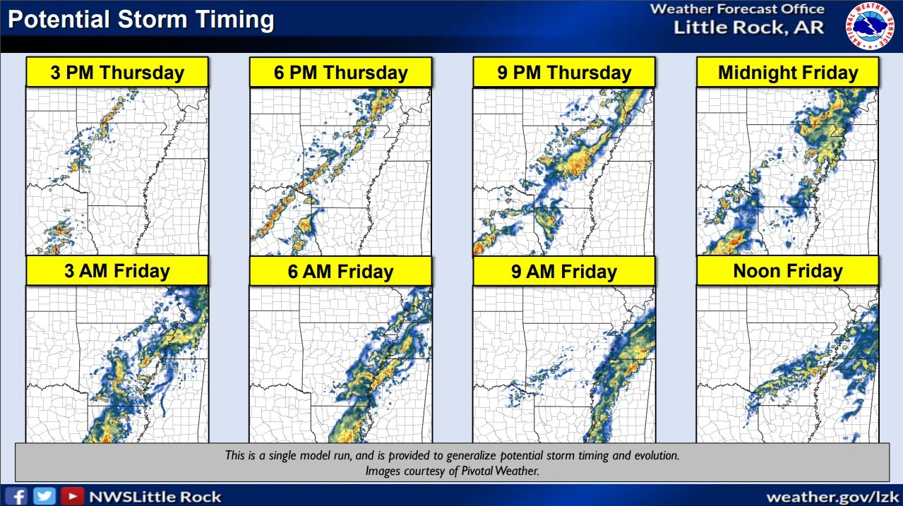
A cold front will sweep across Arkansas Thursday and Friday.
Showers and storms will develop along and ahead of the front, with potential for strong to severe storms to develop.
The primary hazards with these storms will be large hail, damaging winds, with heavy rain and localized flash flooding.
The timing of the development of storms on Thursday will begin early this afternoon across west/northwest AR, with storms continuing to develop along and ahead of the front as it advances east/southeast through early Friday. Rainfall looks to persist through Friday evening across central, south, and eastern portions of the state.
NWS-Little Rock warns of a strong storm system in Arkansas on Friday, March 31

A strong storm system will be in the central United States on Friday. Ahead of the system, a gusty south wind will bring warm temperatures and increasing moisture, and the potential of strong to severe thunderstorms.
The greatest severe weather potential is where the most lift (surrounding a storm system to the north) overlaps the most unstable air (from the southwest). This includes northern Arkansas. Where severe storms develop, the main concerns will be damaging winds and hail, and there may be isolated tornadoes.
Quarter to three quarter inch precipitation totals are in the forecast, with up to an inch in the north. This will not be enough to make existing high water issues (i.e. elevated rivers/saturated soil) worse.

Over 75 million people in central US at risk of severe weather outbreak - Accuweather
At least 15 states will be at risk of an outbreak of violent thunderstorms that will unleash everything from damaging winds to tornadoes on Friday, AccuWeather meteorologists warn. The area highlighted by forecasters is a massive swath of the country that extends from Texas to Alabama in the South to areas farther north such as Wisconsin and Michigan.
The AccuWeather forecast team raised Friday’s risk of severe weather from moderate to a high level prior to the middle of the week, a sign of growing concern for the potential damage the storms could cause.
Severe Weather expected this afternoon and overnight for the ArkLaTex
NATIONAL WEATHER SERVICE
TORNADO WATCH 57 REMAINS VALID UNTIL MIDNIGHT CST TONIGHT FOR THE FOLLOWING AREAS IN ARKANSAS THIS WATCH INCLUDES 6 COUNTIES IN SOUTH CENTRAL ARKANSAS UNION, IN SOUTHWEST ARKANSAS COLUMBIA HEMPSTEAD HOWARD LAFAYETTE NEVADA, IN LOUISIANA THIS WATCH INCLUDES 11 PARISHES IN NORTH CENTRAL LOUISIANA LINCOLN UNION IN NORTHWEST LOUISIANA BIENVILLE BOSSIER CADDO CLAIBORNE DE SOTO NATCHITOCHES RED RIVER SABINE WEBSTER
The National Weather Service in Shreveport has issued a

* Severe Thunderstorm Warning for...
  Little River County in southwestern Arkansas...
  Hempstead County in southwestern Arkansas...
  Northern Miller County in southwestern Arkansas...
  Sevier County in southwestern Arkansas...
  Howard County in southwestern Arkansas...
  Central Bowie County in northeastern Texas...

* Until 1045 PM CST.

* At 943 PM CST, severe thunderstorms were located along a line
  extending from near De Queen to near Horatio to 6 miles west of
  Richmond to 6 miles south of New Boston, moving east at 45 mph.

  HAZARD...70 mph wind gusts and penny size hail.

  SOURCE...Radar indicated. Numerous trees and power lines have been
           downed with these storms across McCurtain County
           Oklahoma. Roof damage has been reported as well.

  IMPACT...Expect considerable tree damage. Damage is likely to
           mobile homes, roofs, and outbuildings.

* Locations impacted include...
  Texarkana, De Queen, Wake Village, Ashdown, Nashville, New Boston,
  Mineral Springs, Dierks, Horatio, Foreman, Umpire, Nash, Hooks,
  Redwater, Red Lick, Lockesburg, Wilton, Blevins, Tollette and
  Fulton.
A Moderate Risk (red) and an Enhanced Risk (orange) remains in place across the region for today and tonight. All modes of severe weather will be possible (tornadoes, hail, wind). Remember, NOW is the time to prepare, don't wait for warnings to be issued before taking action!

Severe weather is likely across the entire region Thursday afternoon, especially in the northwest half of the region, continuing into the overnight hours. The above graphic shows the different tornado, severe hail, and severe wind outlooks. Areas in the significant hatched area have the best chances to see strong EF2 or greater tornadoes, damaging winds of 70-80 mph and hail 2" in diameter or greater.
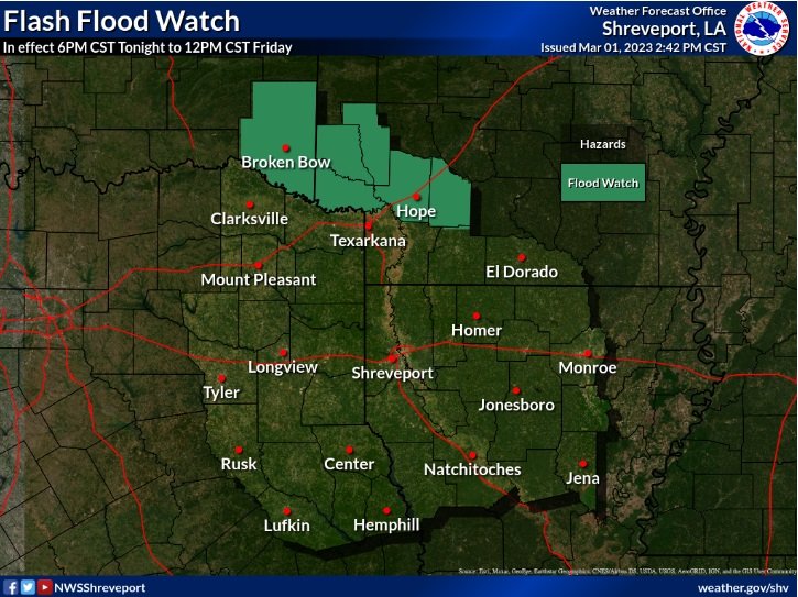
Areas of prolonged rainfall may result in flooding and flash flooding over the next few days. A Flash Flood Watch will go into effect at 6PM this evening, and remain in effect through Noon Friday.

A Wind Advisory will go into effect at noon today and continue through noon on Friday. South to southwest winds of 20 to 30 mph are expected with gusts up to 45 mph possible.

Weather radar at 8:45 pm Thursday
Go to weather.gov on the Internet for more information about the Tornado Watch and Flood Watch.
TORNADO WATCH 55 IS IN EFFECT UNTIL 1030 PM CST FOR THE FOLLOWING LOCATIONS IN ARKANSAS. COUNTIES INCLUDED ARE: LITTLE RIVER, MILLER, AND SEVIER
...FLOOD WATCH IS IN EFFECT FROM 6 PM CST THIS EVENING THROUGH FRIDAY MORNING... A widespread severe weather outbreak appears to be possible this afternoon and into the evening and overnight hours. There will be two main chances for severe weather. The first will come during the early or mid-afternoon hours when we have the potential for discrete supercells. This would pose a threat of large hail and strong tornadoes. The second round will come along just ahead of an advancing cold front that will push through during the late afternoon and into the evening and overnight hours. The main threat for this round will be damaging wind gusts and embedded tornadoes. In addition, moderate to heavy rainfall will be possible from training storms, increasing the potential for Flash Flooding.
Thunderstorms will become numerous this afternoon and continue into tonight, with widespread severe weather likely across much of the region. The greatest risk for severe weather will exist along and east of Highway 281 during the day, shifting east of the I-35 corridor during the evening hours. All modes of severe weather will be possible, including large hail, damaging wind gusts, and tornadoes.
ACCUWEATHER

Thunderstorms on Thursday will erupt from the afternoon into the nighttime hours from Texas through the Ark-La-Tex region and into the lower Mississippi Valley.
This will be the peak of the severe weather risk this week, with AccuWeather forecasters warning of a rare 'high risk' for severe thunderstorms across parts of northeastern Texas, southeastern Oklahoma, northern Louisiana and a large portion of Arkansas. This threat area includes the cities of Dallas, Little Rock, Arkansas, and Shreveport, Louisiana. Damaging hail, perhaps as large as golf or tennis balls, and a few powerful tornadoes will be possible.
Storm chasers, such as extreme meteorologist Reed Timmer, were gathering in the high-risk area early on Thursday, ahead of the expected formation of tornadoes late in the day.
A much wider part of the country, spanning more than a dozen states and extending from southern Texas to Kentucky, can also experience strong thunderstorms that also could produce damaging wind gusts that bring down trees and power lines, as well as flooding downpours that could imperil motorists.
Severe Weather to affect Arkansas Wednesday and Thursday

An active weather pattern is underway with the first round of severe weather expected this afternoon through tonight. An additional round of heavy rain and severe thunderstorms are expected Thursday afternoon through the early morning hours on Friday. Severe weather types include damaging winds, large hail, and tornadoes.
The threat for flash flooding will increase across the central and northern portions of the state over the next few days.
Please see the attached briefing for more details.
National Weather Service in Little Rock, AR