Severe Storms

Severe weather (4/4) and continued heavy rainfall expected for much of Arkansas Friday - NWS/NOAA

The threat for severe weather continues for this Friday into Friday night. All modes of severe weather will be possible including very large hail, damaging winds and even a few tornadoes.

Specifics About Hazards (If Any): A warm front will lift northward into Arkansas today, eventually stalling out once again across the north-central and west-central sections of the state. Conditions along and south of the front will become very unstable by this afternoon as temperatures warm into the 80s. All modes of severe weather will be possible, including damaging winds, large hail and tornadoes. A few long- track tornadoes cannot be ruled out.

There is a high risk for excessive rainfall today into tonight for a large portion of the state. Several inches of rainfall are possible, which may lead to flash and river flooding.

Thunderstorms will remain likely on Saturday into Saturday night, with strong to severe weather potential remaining. All modes of severe weather will be possible Saturday afternoon and evening, including large hail, damaging winds, and a few tornadoes. The highest threat for severe weather on Saturday will be across the southeastern two-thirds of the area.

Areas of heavy rainfall will continue on Saturday into Saturday night as well, with the threat for flash and river flooding continuing to remain a very significant hazard.

Expect the threat for heavy rainfall and severe weather to exit the region by Sunday afternoon. Some areas could see temperatures dropping into the low and mid 30s Sunday and Monday mornings. This may result in some frost or freeze conditions for some areas over northwestern portions of the state. Otherwise, the threat for hazardous weather will become low into the middle of next week.

Several inches of additional rainfall are expected through Sunday morning. Most areas could see an additional 4 to 6 inches, with some areas seeing potentially over 8 inches.

Spotter Activation (Day 1 - Friday/Friday Night): (More Widespread Severe Weather). Scattered to numerous severe storms are expected. The focus area includes much of Arkansas. You can help by monitoring and forwarding severe weather information. If there are strong to severe storms (i.e. wind damage, quarter size hail or larger, etc.) at your location, please consider submitting a report via an online form found here. Thank you for your assistance!

Western Arkansas targeted for Severe Weather Friday

...THERE IS A MODERATE RISK OF SEVERE THUNDERSTORMS THE ARKLATEX INTO WESTERN ARKANSAS...

...SUMMARY...

Several clusters of strong to severe storms are possible from central Texas across the ArkLaTex and into the lower Ohio Valley Friday and Friday night. The greatest threat for tornadoes, large hail and damaging winds will be from the ArkLaTex across western Arkansas, including potential for strong to potentially intense tornadoes.

...Synopsis...

A mid-level trough, centered across the Southwest and northern New Mexico, will start to shift east on Friday. As this occurs a broad, strong low-level jet will develop across eastern Texas and into Louisiana, Arkansas, and Mississippi. This strengthening lower tropospheric flow will aid in the northward advancement of a warm front, located from central Texas to the Mid-Mississippi Valley at the beginning of the period, to eastern Oklahoma an near the MO/AR border by 00Z Sat. This reorientation of the frontal boundary should be favorable for supercells with the potential for large hail (some 2+ inch), damaging wind gusts, and tornadoes (some potentially EF3+).

...ArkLatex to Western Arkansas...

As a warm front lifts north across Arkansas through the day, a very unstable environment (2500-4000 J/kg MLCAPE) will develop from the ArkLaTex into western Arkansas as temperatures warm into the mid 80s with dewpoints in the low 70s. Some weak convection may maintain along the frontal zone in eastern Oklahoma during the morning and early afternoon. However, more robust convective development is not anticipated until mid-afternoon when height falls start to overspread the region, and the influence of the entrance region of the upper-level jet increases ascent. In addition, most high resolution guidance indicates a local area of low pressure may traverse the frontal zone to near northwest Arkansas by 21Z. The combination of these factors, which have decent agreement among 12Z guidance, points toward multiple supercells along the frontal zone during the mid to late afternoon and into the evening. These supercells, in an environment featuring 2500-3500 J/kg MLCAPE and 0-1km SRH ~400 m2/s2, will support the potential for strong to intense tornadoes. Messy storm mode could limit the longevity of any of these supercells/tornadoes, but even with limited duration, the environment supports a tornado threat. A more conditional long-track tornado threat, which would also bring greater opportunity for EF3+ tornadoes, exists east of the frontal boundary. Synoptic forcing ahead of the boundary is relatively weak, but very strong instability (3000-4000 J/kg MLCAPE) is forecast with minimal inhibition across the warm sector. Therefore, more discrete, open warm-sector supercell development is possible, but will be more dependent on mesoscale details which will become more clear in the Day 1 timeframe.

Severe Weather for Arkansas possible on Tuesday

Ahead of a powerful storm system (“L”) in the southern Plains, there will be a lot of shear/turning with height (to promote tornadoes), with a southerly 50 to 70 knot jet at 850 millibars (5,000 feet) and a southwest 70 to 100+ knot jet at 500 millibars (18,000 feet).

  • [WHAT] Strong to possibly severe thunderstorms could impact the state early next week.

  • [WHEN] Tuesday, March 4th.

  • [WHERE] Across much of Arkansas, but especially the eastern half of the state.

    [ADDITIONAL INFO]

  • A strong storm system and cold front are expected to approach by early next week.

  • The system will try to bring warm, moist, and unstable air into the region from the Gulf Coast.

  • If the environment destabilizes enough, severe weather (including tornadoes) will become likely.

    [WHAT HAS CHANGED]

  • It appears an early arrival of precipitation (Tuesday morning) may keep the atmosphere from becoming overly unstable. If rain arrives later, or progresses more slowly to the east, then destabilization will occur. This is very concerning given that available shear will be impressive (to promote tornadoes).

  • Continue to monitor the latest briefings as we assess trends in medium to short-term model data.

Governor Sanders signs an executive order to provide additional relief in regards to tax filing and payment deadlines in response to the May 24th storms in Arkansas

TO ALL TO WHOM THESE PRESENTS COME – GREETINGS: 

E.O. 24-11: EXECUTIVE ORDER TO AMEND E.O. 24-09 AND PROVIDE ADDITIONAL RELIEF IN REGARD TO TAX FILING AND PAYMENT DEADLINES IN RESPONSE TO SEVERE STORMS ON OR ABOUT MAY 24, 2024. 

Wikimedia Image

WHEREAS: On or about May 24, 2024, and continuing, severe storms, flooding, and tornadoes began in Arkansas, causing danger, hardship, and suffering which now warrants this executive action; 

WHEREAS: On May 26, 2024, by Executive Order 24-07, a regional emergency was declared in the state as a result of the severe weather outbreak, pursuant to the Emergency Services Act, codified at Ark. Code Ann. §§ 12-75-101, et. seq; 

WHEREAS: Ark. Code Ann. § 26-18-505 authorizes the Secretary of the Department of Finance and Administration to grant a reasonable extension of time to file any return required under any state tax law upon written request for good cause shown. Good cause includes when any taxpayer is affected by a disaster emergency declared by the Governor; 

WHEREAS: Ark. Code Ann. § 12-75-114(e)(1) authorizes the Governor to suspend any regulatory statutes if compliance with those statutes would delay action in coping with the declared emergency; 

WHEREAS: On May 30, 2024, by Executive Order 24-09, relief was extended to affected citizens in Baxter, Benton, Boone, Carroll, Fulton, Grant, Greene, Madison, Marion, Nevada, Randolph, Sevier, and Sharp counties by extending certain tax payment deadlines; and 

WHEREAS: There is good cause for additional relief to be extended to Arkansans residing in Baxter, Benton, Boone, Carroll, Fulton, Grant, Greene, Madison, Marion, Nevada, Randolph, Sevier, and Sharp counties as a result of the ongoing emergency. 

NOW THEREFORE, I, SARAH HUCKABEE SANDERS, acting under the authority vested in me as Governor of the State of Arkansas and pursuant to Ark. Code Ann. §§ 12-75-101, et seq., issue this Executive Order pursuant to the regional emergency as declared in Executive Order 24-07, and order the following: 

1. The Secretary of the Department of Finance and Administration is hereby ordered to extend the 2023 income tax filing date and income tax payment date and 2023 pass-through entity tax filing date and pass-through entity tax payment date for returns that are due between May 24, 2024, and October 31, 2024, to November 1, 2024, for those citizens and businesses residing in Baxter, Benton, Boone, Carroll, Fulton, Grant, Greene, Madison, Marion, Nevada, Randolph, Sevier, and Sharp counties. This extension includes 2023 returns of Individuals, Subchapter S Corporations, Subchapter C Corporations, Pass-Through Entities, Fiduciaries and Estates, Partnerships, and Composite returns; 

2. Individuals and entities in Baxter, Benton, Boone, Carroll, Fulton, Grant, Greene, Madison, Marion, Nevada, Randolph, Sevier, and Sharp counties will have until November 1, 2024, to file income tax and pass-through entity returns and pay income and pass through entity taxes that were originally due between May 24, 2024, and October 31, 2024; 

3. This relief includes return and extension payments due between May 24, 2024, and October 31, 2024; 

4. The Secretary of the Department of Finance and Administration is hereby ordered to extend the deadline under Ark. Code Ann. § 26-51-913(a)(2) to make a quarterly estimated income tax payment from between May 24, 2024, and October 31, 2024, for those citizens and businesses located in Baxter, Benton, Boone, Carroll, Fulton, Grant, Greene, Madison, Marion, Nevada, Randolph, Sevier, and Sharp counties to November 1, 2024; 

5. The provisions of Ark. Code Ann. § 26-18-505(a)(1) requiring a written request for an extension to file an individual income tax return are hereby waived through November 1, 2024, for citizens who reside or whose businesses are located in Baxter, Benton, Boone, Carroll, Fulton, Grant, Greene, Madison, Marion, Nevada, Randolph, Sevier, and Sharp counties; 

6. The provisions of Ark. Code Ann. § 26-18-505(a)(3) limiting an extension for filing an individual income tax return to no more than 180 days is hereby waived through November 1, 2024, for citizens who reside or whose businesses are located in Baxter, Benton, Boone, Carroll, Fulton, Grant, Greene, Madison, Marion, Nevada, Randolph, Sevier, and Sharp counties; and 

7. The provisions of Ark. Code Ann. § 26-18-505(a)(4) requiring the promulgation of rules to waive the requirement for a written request for an extension are hereby waived through November 1, 2024. 

IN TESTIMONY WHEREOF, I have hereunto set my hand and caused the Great Seal of the State of Arkansas to be affixed on this 15th day of July, in the year of our Lord 2024.

Severe Weather Briefing from the National Weather Service

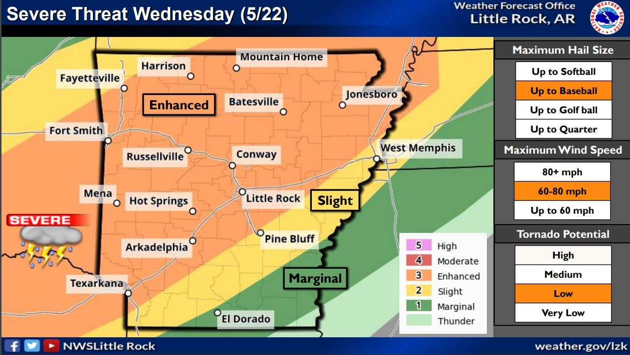
  • A cold front will push through Arkansas beginning on Wednesday morning along the Arkansas/Missouri border in the north and traverse the state moving southward during the day. Strong to severe thunderstorms are likely to be present along this cold front as it moves across the state from north to south.

  • Re-development or rejuvenation of thunderstorm activity will be possible as the cold front moves across central and into southern Arkansas into the early afternoon hours on Wednesday.

  • Damaging wind gusts and large hail are the primary concerns. The tornado threat is very low, but a brief tornado cannot be ruled out.

Severe Weather Possible Wednesday and Thursday in Arkansas

  • An active weather pattern will continue across the region through the weekend, with some threat for strong to severe thunderstorms forecast through the weekend.

  • Chances for severe weather will be greatest across the southwest section of the state through tonight. The threat on Thursday will be less concentrated, but may be more focused for western sections. Chances for severe weather will be a tad lower on Friday…but return for Saturday and Sunday.

  • The primary threats expected with the strongest storms will be large hail and damaging winds, with some tornadoes also possible. Very large hail over 2 inches in diameter and damaging winds over 70 mph could be seen across southwest sections of the state this Wednesday afternoon.

  • Some areas of heavy rainfall could be seen by late this week. Additional rainfall amounts exceeding 1.5 inches could be seen through Memorial Day, especially across the south half of the state. Locally heavier amounts are possible. This may lead to some isolated flash flooding.

National Weather Service Hazardous Weather Briefing for Arkansas Tues-Thurs

Severe Threat for Arkansas Late This Afternoon and Tonight - (National Weather Service/Little Rock Graph)

  • An active weather pattern will develop starting late this afternoon and evening as a cold front drops southeast towards Arkansas.

  • Chances for severe weather will increase starting late this evening into the overnight hours across far northwest sections of Arkansas. This threat will spread further southeast for Wednesday, and continue for a large portion of the state on Thursday.

  • The primary threats expected with the strongest storms through tonight will be large hail and damaging winds, with a brief tornado or two possible. Very large hail and damaging winds will be the primary threats on Wednesday, with a few tornadoes also possible. Large hail and damaging winds will again be primary threats for Thursday.

  • There is some uncertainty regarding the severe threat on Wednesday as timing of morning thunderstorms may create less instability for afternoon thunderstorm development.

  • Some areas of heavy rainfall could be seen by late this week. Rainfall amounts exceeding 3 inches could be seen from late tonight through Friday morning. This may lead to some isolated flash flooding.

National Weather Service Severe Weather Briefing

A cold front will push through Arkansas from the Plains on Thursday. Ahead of the front, very warm conditions/well above normal temperatures will exist, creating a very unstable environment.

A broken line of scattered strong to severe thunderstorms are expected to develop across the northwest counties Thursday afternoon. The line is then expected to move towards central and northeastern locations Thursday evening and night. There are indications the line will gradually weaken after the sun sets, and daytime heating is lost.

Large hail and damaging winds are the primary concerns, especially across northern and extreme western parts of the state. A low, but non-zero tornado chances exists across the northeastern half of the state.

Severe Weather Briefing from the National Weather Service

  • An unsettled weather pattern will continue today/tonight. Showers and scattered thunderstorms remain in the forecast, and areas of heavy rain are expected.

  • The forecast calls for an additional half inch to more than two inches of rain across Arkansas. Spotty flash flooding is possible, and some minor river flooding is likely to occur or is ongoing.

  • While the primary concern will be heavy rain, there could be isolated severe storms across southern Arkansas. More significant severe weather is likely farther south along the Gulf Coast (from Louisiana into Mississippi and Alabama).

Severe Weather Briefing for Arkansas from the National Weather Service

Strong to severe thunderstorms are still expected to develop late this evening and continue into Monday night. The only real change to the forecast is the computer models continue to slow the progression of the system down.  

The northwest part of Arkansas continues to have the best chances of seeing severe weather with decreasing chances further to the southeast.

  •  Showers and thunderstorms are expected to develop Monday evening and into early Tuesday morning ahead of an approaching cold front. The computer models continue their trend of late in slowing the system down.

  • Some storms are expected to become strong to severe, especially over the northwest half of Arkansas. These locations will have the greatest overlap of severe thunderstorm ingredients Monday evening and into early Tuesday. While all severe weather hazards will be possible, large hail and damaging winds will be the primary concerns and isolated tornadoes will be possible.

  • Large hail and damaging straight-line winds are possible across the rest of the state as well, but chances decrease toward the south and east as the storms are forecast to weaken.

  • Southerly winds gusting upwards of 30 mph will be possible on Monday afternoon and evening.

Severe storms are possible for the upcoming weekend according to the National Weather Service

  • A strong cold front will surge through Arkansas from the Plains on Saturday. The front will trigger showers and thunderstorms.

  • There is a risk of severe thunderstorms on Saturday as the front plows into an unseasonably mild (springlike) and unstable environment across the state. Data currently indicates all modes of severe weather (including tornadoes, damaging winds, and hail) will be possible.

  • Cooler and more seasonal air will follow the front Saturday night and Sunday. Residual moisture may yield a few snowflakes in the Ozark Mountains before precipitation ends Sunday afternoon.

The National Weather Service indicates additional severe weather expected for Arkansas Tuesday and Wednesday

Rain and thunderstorms that moved across the state overnight have pushed east of the area. Rainfall amounts across southern Arkansas were generally in the 1-2 inch range. Amounts decrease as you go north.  

Mostly dry conditions are expected across the state today, southerly winds could be gusty at times. Very warm temperatures are expected today and Tuesday, highs could approach 90° in some areas both days.  

There will be an opportunity for strong to severe thunderstorms to develop and move across the state from Tuesday evening through Wednesday morning. All severe weather hazards appear possible, an enhanced risk of severe weather remains in place. The threat for severe weather should wrap up before noon Wednesday as a cold front moves east of the area.  

Locally heavy rain is possible Tuesday and Wednesday, the highest amounts are expected across far southern Arkansas. 

Severe weather risk for the ArkLaTex Friday

Showers and thunderstorms this morning will decrease in coverage before redevelopment later this afternoon. A squall line is then expected to sweep across the state.with the possibility of strong tornadoes with the best chances over the southeast. 

In addition to the severe threat, flooding is a concern. Several inches of rain fell across parts of northwest Arkansas last night with additional widespread rain expected. The precipitation is expected to exit the state late this evening.

Severe weather risk for Arkansas Thursday and Friday

A strong storm system is expected to bring showers and thunderstorms to the state Thursday through Friday night. Some of these storms could become strong to severe. In addition to the threat for severe weather, there is also a threat for flooding due to the expected heavy rainfall. Please see the attached briefing for more details.

There is a Marginal Risk for severe thunderstorm late on Thursday into early Friday, along and mainly north of our I-30 corridor. Damaging winds and large hail will be the primary threats and locally heavy rainfall could bring isolated flash flooding.

Locally heavy rainfall from a line of strong to possibly severe thunderstorms, could result in isolated flash flooding late Thursday into early Friday with the Slight Risk north of our I-30 corridor.

A line of strong to severe storms will continue across the area during early Friday with afternoon heating firing up a Slight Risk for severe storms in deep E TX, all of our Parishes and south central AR during the afternoon. Damaging winds and large hail will be the primary threats and locally heavy rainfall could bring isolated flash flooding.

Severe Weather Briefing for Arkansas on Thursday; Freeze watch also in effect for the weekend

A round of showers and thunderstorms will move across the state later today into tonight and some of these storms could become strong to severe. Damaging winds will be the primary hazard.

Showers and thunderstorms will begin to increase late this morning in Northeast Texas, Southeast Oklahoma, Southwest Arkansas, and even Northwest Louisiana by early this afternoon. All of this well ahead of a strong cold front and associated upper level disturbance that will approach the region from the west tonight. An isolated severe threat exists with these afternoon storms with large hail possible, but the majority of our severe weather threat will hold off until late this afternoon as the warm front comes into play. Then the thunderstorms gradually become more surface based moving eastward and better organize ahead of the strong cold front as it moves across I-30 this evening. The thunderstorms will merge into a potent squall line, while moving southeastward ahead of the cold front this evening. Large hail, damaging winds, and isolated tornadoes are the main threats late this afternoon and on through much of Thursday night, before diminishing in the predawn hours. Locally heavy rainfall will also be possible with 2 inches or more in the stronger storms, which may result in minor flooding of our low lying and poor drainage areas.

...FREEZE WATCH IN EFFECT FOR SW ARKANSAS AND SE OKLAHOMA FROM LATE FRIDAY NIGHT THROUGH SATURDAY MORNING...

* WHAT...Sub-freezing temperatures as low as 32 possible.

* WHERE...In Arkansas, Sevier County, Howard County, Little
  River County, Hempstead County and Nevada County. In Oklahoma,
  McCurtain County.

* WHEN...From late Friday night through Saturday morning.

* IMPACTS...Frost and freeze conditions could kill crops, other
  sensitive vegetation and possibly damage unprotected outdoor
  plumbing.


PRECAUTIONARY/PREPAREDNESS ACTIONS...

Take steps now to protect tender plants from the cold. To prevent
freezing and possible bursting of outdoor water pipes they should
be wrapped, drained, or allowed to drip slowly. Those that have
in-ground sprinkler systems should drain them and cover above-
ground pipes to protect them from freezing.


Weekend's Severe Weather Briefing for Arkansas

  • A new storm system moves into the region on Saturday, followed by a cold front that will move through the state during the afternoon/evening timeframe. During this period, we expect another round of unsettled weather, with a few strong or severe storms possible. The main hazards look to be hail and damaging winds.

  • It’s important to remember that additional updates will be provided as we get closer to Saturday, and specifics will become ironed out further.

Attached is a severe weather briefing concerning the rainfall totals that are expected through the day on Sunday as well as the possibility of severe weather on Saturday. 

Severe Weather to affect Arkansas Wednesday and Thursday

An active weather pattern is underway with the first round of severe weather expected this afternoon through tonight. An additional round of heavy rain and severe thunderstorms are expected Thursday afternoon through the early morning hours on Friday. Severe weather types include damaging winds, large hail, and tornadoes.

The threat for flash flooding will increase across the central and northern portions of the state over the next few days.

Please see the attached briefing for more details.

National Weather Service in Little Rock, AR

Weather Briefing from the National Weather Service in Little Rock

Confidence continues to increase on a severe weather event for most of the southeastern half of the state beginning Tuesday afternoon/evening and potentially persisting into the early morning hours of Wednesday.

The Day 3 Storm Prediction Center Convective Outlook brought an expansion of the Enhanced Risk area into much of eastern and northeastern Arkansas. Specific timing details will become more evident in the next day or so, however additional changes to the forecast risk area are still possible within the next few days.

Increased Threat of Severe Weather Friday Evening in Arkansas

A fairly major update has been made to the severe weather forecast through tonight. Here are the main points: 

Moderate Risk introduced for all of western, southwestern AR

- Increased threat for tornadoes, some potentially significant, in and near southwest 

  AR. Damaging hail is also possible.

- Intense winds (up to 70-80 mph) possible as storms move across AR late evening 

  and overnight

Enhanced Risk expanded to include the southern half of AR.

Onset timing remains the same (5-7 PM), but storms will move across AR faster than previously thought with storms moving east of the MS River by 3-4 AM.

The attached briefing contains updated graphics pertaining to the severe threat and timing.