
[WHAT] Severe weather and heavy rainfall
[WHEN] Late Tuesday night through Saturday night. ○ Severe weather threat late Tuesday night through Thursday. ○ Heavy rainfall and resulting flash/river flooding threat Wednesday through Saturday.
[WHERE] Most of the state will be at risk for severe weather as well as the heavy rainfall.

Severe Weather for Arkansas possible on Tuesday

Ahead of a powerful storm system (“L”) in the southern Plains, there will be a lot of shear/turning with height (to promote tornadoes), with a southerly 50 to 70 knot jet at 850 millibars (5,000 feet) and a southwest 70 to 100+ knot jet at 500 millibars (18,000 feet).
[WHAT] Strong to possibly severe thunderstorms could impact the state early next week.
[WHEN] Tuesday, March 4th.
[WHERE] Across much of Arkansas, but especially the eastern half of the state.
[ADDITIONAL INFO]
A strong storm system and cold front are expected to approach by early next week.
The system will try to bring warm, moist, and unstable air into the region from the Gulf Coast.
If the environment destabilizes enough, severe weather (including tornadoes) will become likely.
[WHAT HAS CHANGED]
It appears an early arrival of precipitation (Tuesday morning) may keep the atmosphere from becoming overly unstable. If rain arrives later, or progresses more slowly to the east, then destabilization will occur. This is very concerning given that available shear will be impressive (to promote tornadoes).
Continue to monitor the latest briefings as we assess trends in medium to short-term model data.
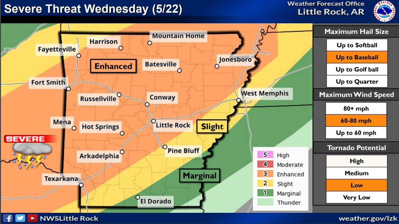
Severe Weather Possible Wednesday and Thursday in Arkansas

An active weather pattern will continue across the region through the weekend, with some threat for strong to severe thunderstorms forecast through the weekend.
Chances for severe weather will be greatest across the southwest section of the state through tonight. The threat on Thursday will be less concentrated, but may be more focused for western sections. Chances for severe weather will be a tad lower on Friday…but return for Saturday and Sunday.
The primary threats expected with the strongest storms will be large hail and damaging winds, with some tornadoes also possible. Very large hail over 2 inches in diameter and damaging winds over 70 mph could be seen across southwest sections of the state this Wednesday afternoon.
Some areas of heavy rainfall could be seen by late this week. Additional rainfall amounts exceeding 1.5 inches could be seen through Memorial Day, especially across the south half of the state. Locally heavier amounts are possible. This may lead to some isolated flash flooding.

National Weather Service Hazardous Weather Briefing for Arkansas Tues-Thurs

Severe Threat for Arkansas Late This Afternoon and Tonight - (National Weather Service/Little Rock Graph)
An active weather pattern will develop starting late this afternoon and evening as a cold front drops southeast towards Arkansas.
Chances for severe weather will increase starting late this evening into the overnight hours across far northwest sections of Arkansas. This threat will spread further southeast for Wednesday, and continue for a large portion of the state on Thursday.
The primary threats expected with the strongest storms through tonight will be large hail and damaging winds, with a brief tornado or two possible. Very large hail and damaging winds will be the primary threats on Wednesday, with a few tornadoes also possible. Large hail and damaging winds will again be primary threats for Thursday.
There is some uncertainty regarding the severe threat on Wednesday as timing of morning thunderstorms may create less instability for afternoon thunderstorm development.
Some areas of heavy rainfall could be seen by late this week. Rainfall amounts exceeding 3 inches could be seen from late tonight through Friday morning. This may lead to some isolated flash flooding.
Severe weather likely in Arkansas beginning Wednesday evening; briefing updated

Severe storms are expected to fire across Arkansas this afternoon into the overnight hours.
Chances for severe weather will increase through the day as a storm system tracks from the southern Plains to the mid-Mississippi Valley, and drags a cold front into Arkansas. Ahead of the front, well above average temperatures and humid conditions will create a very unstable environment.
All modes of severe weather are in play this afternoon and overnight. Very large hail up to baseball size and wind gusts up to 80 mph are the main threats, with tornadoes also possible. Heavy downpours may lead to localized flash flooding as well.
On Thursday, storms will be mostly south of Arkansas but could impact far southern portions of the state. Damaging winds and large hail would be the main hazards.
Minor updates have been made by the National Weather Service in Little Rock, AR.
They include the addition of NW Arkansas to the Tornado Outlook and Overnight Timing Graphics.
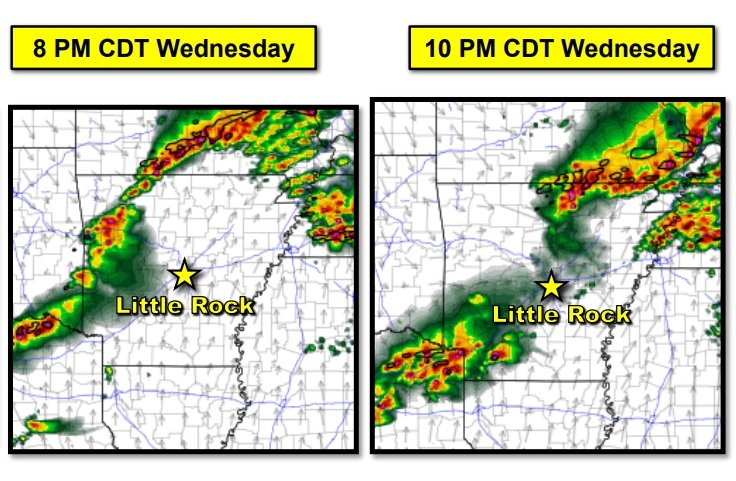
Storms are expected to initially develop by early evening across northern and western Arkansas. These storms will be capable of all severe weather hazards. The storms will gradually shift eastward through the evening hours with the very large hail threat becoming slightly lower. The damaging wind and isolated tornado threat will persist. Activity should make it east of the Mississippi River by daybreak Thursday.
Severe Weather Briefing from the NWS Little Rock

A northward lifting warm front on Friday, in tandem with an approaching dryline from the west in eastern Oklahoma, will initiate an opportunity for strong to severe thunderstorms to develop and move into Arkansas.
All modes of severe weather will be possible from large hail, damaging wind gusts, and a few tornadoes.
Excessive rainfall will also accompany this system which will present the risk for flash flooding, especially in vulnerable locations for flash flooding as early as Thursday through Friday night.
Severe Weather Briefing from the National Weather Service in Little Rock

A powerful storm system in the central Plains will drag a cold front towards Arkansas Tuesday afternoon into early Wednesday.
Ahead of the front, scattered strong to severe thunderstorms are expected to develop tracking across portions of central and northern Arkansas. Damaging straight-line winds and hail appear to be the primary concern associated with storms Tuesday afternoon.
An additional round of severe weather will be possible Thursday across portions of the state. Once again damaging winds and hail will be the primary concern with this system.
Severe Weather Briefing for Arkansas from the National Weather Service

Strong to severe thunderstorms are still expected to develop late this evening and continue into Monday night. The only real change to the forecast is the computer models continue to slow the progression of the system down.
The northwest part of Arkansas continues to have the best chances of seeing severe weather with decreasing chances further to the southeast.
Showers and thunderstorms are expected to develop Monday evening and into early Tuesday morning ahead of an approaching cold front. The computer models continue their trend of late in slowing the system down.
Some storms are expected to become strong to severe, especially over the northwest half of Arkansas. These locations will have the greatest overlap of severe thunderstorm ingredients Monday evening and into early Tuesday. While all severe weather hazards will be possible, large hail and damaging winds will be the primary concerns and isolated tornadoes will be possible.
Large hail and damaging straight-line winds are possible across the rest of the state as well, but chances decrease toward the south and east as the storms are forecast to weaken.
Southerly winds gusting upwards of 30 mph will be possible on Monday afternoon and evening.
Severe Weather Briefing for Arkansas on Thursday from the National Weather Service
Scattered strong to severe thunderstorms are expected to develop in eastern Oklahoma this afternoon and move into Arkansas later this afternoon and early evening. These storms will be capable of all severe hazards through later tonight.

The main changes with this briefing include:
-- An expansion of the "Enhanced Risk" area towards northeastern Arkansas
-- The introduction of a 10% Tornado Risk Area over northwestern to northern central Arkansas
Large and damaging hail remains the primary threat with storms today, though all modes of severe weather will be possible today and tonight.
Click on the attached briefing below for more specific forecast information.
Severe Weather Briefing for Arkansas on Thursday; Freeze watch also in effect for the weekend

A round of showers and thunderstorms will move across the state later today into tonight and some of these storms could become strong to severe. Damaging winds will be the primary hazard.
Showers and thunderstorms will begin to increase late this morning in Northeast Texas, Southeast Oklahoma, Southwest Arkansas, and even Northwest Louisiana by early this afternoon. All of this well ahead of a strong cold front and associated upper level disturbance that will approach the region from the west tonight. An isolated severe threat exists with these afternoon storms with large hail possible, but the majority of our severe weather threat will hold off until late this afternoon as the warm front comes into play. Then the thunderstorms gradually become more surface based moving eastward and better organize ahead of the strong cold front as it moves across I-30 this evening. The thunderstorms will merge into a potent squall line, while moving southeastward ahead of the cold front this evening. Large hail, damaging winds, and isolated tornadoes are the main threats late this afternoon and on through much of Thursday night, before diminishing in the predawn hours. Locally heavy rainfall will also be possible with 2 inches or more in the stronger storms, which may result in minor flooding of our low lying and poor drainage areas.
...FREEZE WATCH IN EFFECT FOR SW ARKANSAS AND SE OKLAHOMA FROM LATE FRIDAY NIGHT THROUGH SATURDAY MORNING...

* WHAT...Sub-freezing temperatures as low as 32 possible.

* WHERE...In Arkansas, Sevier County, Howard County, Little
  River County, Hempstead County and Nevada County. In Oklahoma,
  McCurtain County.

* WHEN...From late Friday night through Saturday morning.

* IMPACTS...Frost and freeze conditions could kill crops, other
  sensitive vegetation and possibly damage unprotected outdoor
  plumbing.


PRECAUTIONARY/PREPAREDNESS ACTIONS...

Take steps now to protect tender plants from the cold. To prevent
freezing and possible bursting of outdoor water pipes they should
be wrapped, drained, or allowed to drip slowly. Those that have
in-ground sprinkler systems should drain them and cover above-
ground pipes to protect them from freezing.
Severe Weather Briefing for Arkansas Wednesday and Thursday

Scattered to numerous thunderstorms will begin moving across the region on Wednesday, with some storms capable of producing hail and strong wind gusts. On Thursday, another round of strong to severe thunderstorms will be possible from late afternoon into the overnight hours when large hail, damaging winds, and tornadoes will all be possible.
Increased Threat of Severe Weather Friday Evening in Arkansas

A fairly major update has been made to the severe weather forecast through tonight. Here are the main points:
Moderate Risk introduced for all of western, southwestern AR
- Increased threat for tornadoes, some potentially significant, in and near southwest
AR. Damaging hail is also possible.
- Intense winds (up to 70-80 mph) possible as storms move across AR late evening
and overnight
Enhanced Risk expanded to include the southern half of AR.
Onset timing remains the same (5-7 PM), but storms will move across AR faster than previously thought with storms moving east of the MS River by 3-4 AM.
The attached briefing contains updated graphics pertaining to the severe threat and timing.