Damaging Winds

Western Arkansas targeted for Severe Weather Friday

...THERE IS A MODERATE RISK OF SEVERE THUNDERSTORMS THE ARKLATEX INTO WESTERN ARKANSAS...

...SUMMARY...

Several clusters of strong to severe storms are possible from central Texas across the ArkLaTex and into the lower Ohio Valley Friday and Friday night. The greatest threat for tornadoes, large hail and damaging winds will be from the ArkLaTex across western Arkansas, including potential for strong to potentially intense tornadoes.

...Synopsis...

A mid-level trough, centered across the Southwest and northern New Mexico, will start to shift east on Friday. As this occurs a broad, strong low-level jet will develop across eastern Texas and into Louisiana, Arkansas, and Mississippi. This strengthening lower tropospheric flow will aid in the northward advancement of a warm front, located from central Texas to the Mid-Mississippi Valley at the beginning of the period, to eastern Oklahoma an near the MO/AR border by 00Z Sat. This reorientation of the frontal boundary should be favorable for supercells with the potential for large hail (some 2+ inch), damaging wind gusts, and tornadoes (some potentially EF3+).

...ArkLatex to Western Arkansas...

As a warm front lifts north across Arkansas through the day, a very unstable environment (2500-4000 J/kg MLCAPE) will develop from the ArkLaTex into western Arkansas as temperatures warm into the mid 80s with dewpoints in the low 70s. Some weak convection may maintain along the frontal zone in eastern Oklahoma during the morning and early afternoon. However, more robust convective development is not anticipated until mid-afternoon when height falls start to overspread the region, and the influence of the entrance region of the upper-level jet increases ascent. In addition, most high resolution guidance indicates a local area of low pressure may traverse the frontal zone to near northwest Arkansas by 21Z. The combination of these factors, which have decent agreement among 12Z guidance, points toward multiple supercells along the frontal zone during the mid to late afternoon and into the evening. These supercells, in an environment featuring 2500-3500 J/kg MLCAPE and 0-1km SRH ~400 m2/s2, will support the potential for strong to intense tornadoes. Messy storm mode could limit the longevity of any of these supercells/tornadoes, but even with limited duration, the environment supports a tornado threat. A more conditional long-track tornado threat, which would also bring greater opportunity for EF3+ tornadoes, exists east of the frontal boundary. Synoptic forcing ahead of the boundary is relatively weak, but very strong instability (3000-4000 J/kg MLCAPE) is forecast with minimal inhibition across the warm sector. Therefore, more discrete, open warm-sector supercell development is possible, but will be more dependent on mesoscale details which will become more clear in the Day 1 timeframe.

Severe Weather Continues Thursday for Arkansas

  • WHAT - Widespread Severe Weather and Excessive Rainfall. ○ Severe weather remains possible Thursday through Saturday across the majority of Arkansas. All modes of severe weather remain possible including a few tornadoes. ○ Extreme rainfall, with an additional 8 to 10 inches possible across parts of the state. This amount of rain is in addition to what has already fallen. Dangerous and potentially life threatening flash flooding and river flooding are expected.

  • WHEN - Today through Saturday night. ○ Severe weather threat time frames: ■ (1) Thursday afternoon through Thursday night (all but far northwest and far southeast Arkansas) ■ (3) Friday afternoon through Friday night (all but far northwest and far southeast Arkansas) ■ (4) Saturday afternoon through Saturday night (southeast half of Arkansas) ○ Heavy rainfall and flash/river flooding threat Thursday through Saturday.

  • WHERE - Most of the state will be at risk for severe weather and heavy rainfall through Saturday.

Attached is the latest weather briefing concerning this multi day severe weather and flooding event. In a nutshell, a large part of central Arkansas will be under an enhanced risk of severe weather Thursday and Friday with the threat area shifting south for Saturday.  All modes of severe weather will be possible.

Waves of heavy rain will impact the state through Saturday as several waves of low pressure interact with a stalled front. Parts of the state could see up to 10 inches of rain in addition to what fell on Wednesday.

Widespread and significant flash and river flooding are expected.

…….National Weather Service in Little Rock

Severe Weather Threat for Arkansas

  • WHAT - Severe weather and heavy rainfall. ○ Very large hail, damaging wind gusts, and tornadoes will be possible on Wednesday with additional chances of severe weather Thursday through Saturday. . ○ Extremely heavy rainfall, more than 10 inches possible. Dangerous and potentially life threatening flash flooding and river flooding are expected.

  • WHEN - Today through Saturday night. ○ Severe weather threat timeframes: (1) Wednesday afternoon through Wednesday night (entire state) (2) Thursday afternoon through Thursday night (all but far northwest Arkansas) (3) Friday afternoon through Friday night (all but far northwest and far southeast Arkansas) (4) Saturday afternoon through Saturday night (southeast half of Arkansas) ○ Heavy rainfall and resulting flash/river flooding threat Wednesday through Saturday.

  • WHERE - Most of the state will be at risk for severe weather and heavy rainfall.

The latest Severe Weather Briefing from the National Weather Service in Little Rock

  • [WHAT] Severe weather and heavy rainfall. ○ Very large hail, damaging wind gusts and tornadoes. ○ Extremely heavy rainfall, more than 10 inches possible. Flash flooding and river flooding likely

  • [WHEN] Late Tuesday night through Saturday night. ○ Severe weather threat timeframes: ■ (1) Tuesday night into Wednesday morning (mainly across the far northwest corner) ■ (2) Wednesday afternoon through Wednesday night (entire state) ■ (3) Thursday afternoon through Thursday night (all but NW Arkansas) ○ Heavy rainfall and resulting flash/river flooding threat Wednesday through Saturday.

  • [WHERE] Most of the state will be at risk for severe weather and heavy rainfall

Severe Weather Outlook for Arkansas today

  • [WHAT] Strong to possibly a few severe thunderstorms are likely to impact Arkansas.

  • [WHEN] Today, Tuesday March 4, 2025.

  • [WHERE] Most of the state, but especially portions of central Arkansas, and all of southern Arkansas.

    [ADDITIONAL INFO]

  • If the environment destabilizes enough, severe weather (including tornadoes) will become likely.

  • Gusty winds in excess of 40+ mph will be possible ahead of the thunderstorm activity and after the passage of the thunderstorm activity through Wednesday.

    [KEEP IN MIND]

  • The early arrival of precipitation (this morning) may keep the atmosphere from becoming overly unstable. If rain arrives later, or progresses more slowly to the east, then destabilization will occur. This is very concerning given that available shear will be impressive (to promote tornadoes).

  • This will be the last severe weather briefing regarding the severe thunderstorms moving across the state today.

The most widespread hazard across Arkansas today will be the risk for damaging wind gusts. Damaging wind gusts will be possible statewide; however, southern portions of the state will see the highest potential for severe winds. (Note the hatched area across southern Arkansas which indicates a 10% or greater chance for significant severe winds equal to or greater than 74 mph.)

Tropical Storm Beryl Briefing from the National Weather Service

Areas from southwest to north-central Arkansas could see the highest totals (isolated 4-6 inch amounts)

This map shows rainfall totals through Tuesday night, which includes some rainfall expected before Beryl moves through.

  • TS Beryl will move onshore along the Texas coast late tonight into early Monday morning, likely as a hurricane.

  • Beryl will quickly weaken and move toward the north then northeast, traveling across east/northeast Texas Monday into early Tuesday morning.

  • The remnants of Beryl are expected to move across Arkansas from Monday afternoon through Tuesday before lifting northeast of the state by early Wednesday morning.

  • The remnants of Beryl could provide some locally heavy rain and perhaps a few tornadoes/damaging wind gusts across Arkansas from Monday afternoon through Tuesday afternoon.

NOTE: Do not focus on the exact track. Impacts can occur well outside the area enclosed by the cone

Severe Weather Briefing from the National Weather Service

  • A cold front will push through Arkansas beginning on Wednesday morning along the Arkansas/Missouri border in the north and traverse the state moving southward during the day. Strong to severe thunderstorms are likely to be present along this cold front as it moves across the state from north to south.

  • Re-development or rejuvenation of thunderstorm activity will be possible as the cold front moves across central and into southern Arkansas into the early afternoon hours on Wednesday.

  • Damaging wind gusts and large hail are the primary concerns. The tornado threat is very low, but a brief tornado cannot be ruled out.

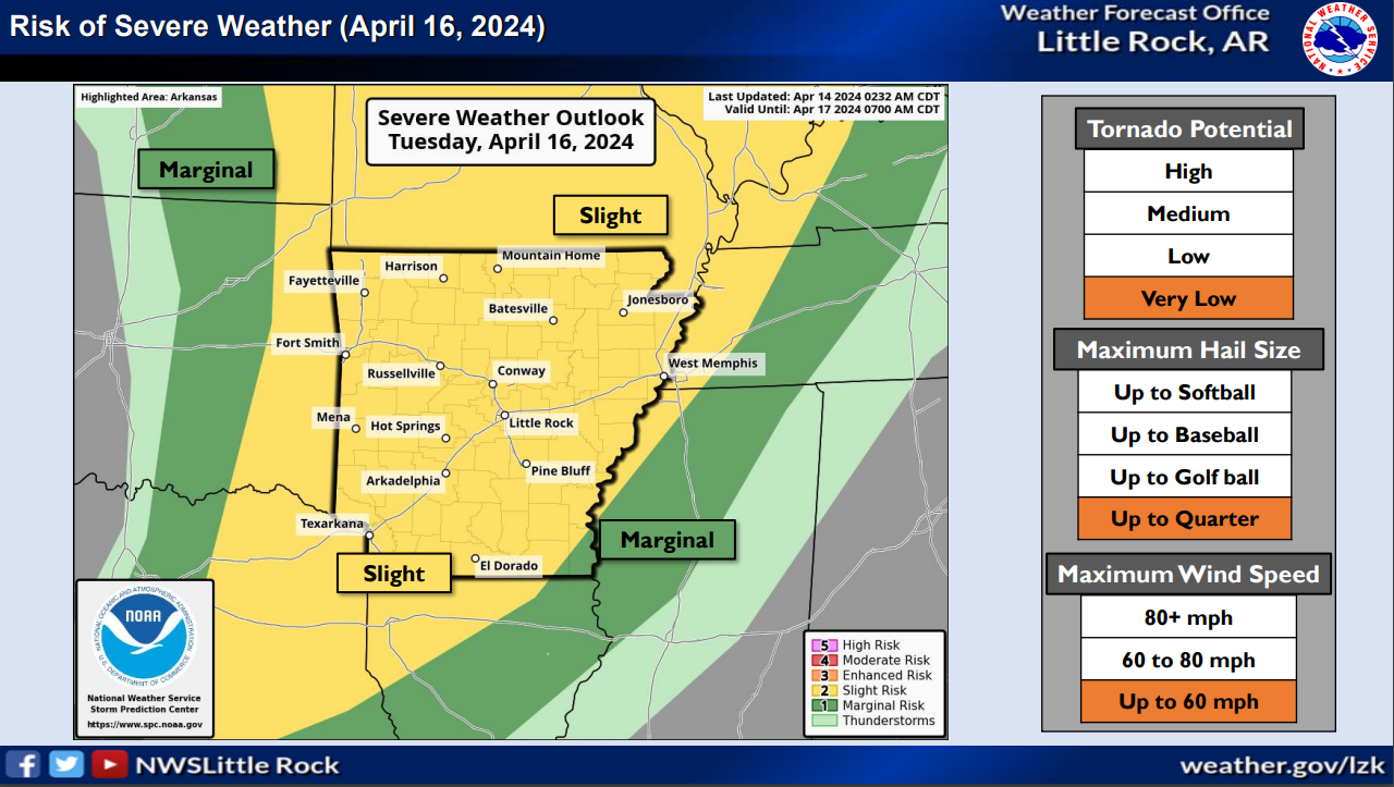
NWS Severe Weather Outlook for Arkansas June 3, 2024

  • A complex of strong to severe thunderstorms will develop along a line that will enter northwestern Arkansas by Monday afternoon and sweep southeastward across the state into Monday evening.

  • Damaging wind gusts and quarter sized hail will be possible in any storm that becomes severe.

  • The tornado threat in this environment remains very low, but not zero.

  • The Flash Flooding threat with this system is low, but locations that saw high rainfall totals with the activity from Thursday and locations that experience efficient rainfall producing cells this afternoon/evening may see flash flooding, especially in prone areas.

Severe Weather Possible Wednesday and Thursday in Arkansas

  • An active weather pattern will continue across the region through the weekend, with some threat for strong to severe thunderstorms forecast through the weekend.

  • Chances for severe weather will be greatest across the southwest section of the state through tonight. The threat on Thursday will be less concentrated, but may be more focused for western sections. Chances for severe weather will be a tad lower on Friday…but return for Saturday and Sunday.

  • The primary threats expected with the strongest storms will be large hail and damaging winds, with some tornadoes also possible. Very large hail over 2 inches in diameter and damaging winds over 70 mph could be seen across southwest sections of the state this Wednesday afternoon.

  • Some areas of heavy rainfall could be seen by late this week. Additional rainfall amounts exceeding 1.5 inches could be seen through Memorial Day, especially across the south half of the state. Locally heavier amounts are possible. This may lead to some isolated flash flooding.

National Weather Service Hazardous Weather Briefing for Arkansas Tues-Thurs

Severe Threat for Arkansas Late This Afternoon and Tonight - (National Weather Service/Little Rock Graph)

  • An active weather pattern will develop starting late this afternoon and evening as a cold front drops southeast towards Arkansas.

  • Chances for severe weather will increase starting late this evening into the overnight hours across far northwest sections of Arkansas. This threat will spread further southeast for Wednesday, and continue for a large portion of the state on Thursday.

  • The primary threats expected with the strongest storms through tonight will be large hail and damaging winds, with a brief tornado or two possible. Very large hail and damaging winds will be the primary threats on Wednesday, with a few tornadoes also possible. Large hail and damaging winds will again be primary threats for Thursday.

  • There is some uncertainty regarding the severe threat on Wednesday as timing of morning thunderstorms may create less instability for afternoon thunderstorm development.

  • Some areas of heavy rainfall could be seen by late this week. Rainfall amounts exceeding 3 inches could be seen from late tonight through Friday morning. This may lead to some isolated flash flooding.

Severe weather likely in Arkansas beginning Wednesday evening; briefing updated

  • Severe storms are expected to fire across Arkansas this afternoon into the overnight hours.

  • Chances for severe weather will increase through the day as a storm system tracks from the southern Plains to the mid-Mississippi Valley, and drags a cold front into Arkansas. Ahead of the front, well above average temperatures and humid conditions will create a very unstable environment.

  • All modes of severe weather are in play this afternoon and overnight. Very large hail up to baseball size and wind gusts up to 80 mph are the main threats, with tornadoes also possible. Heavy downpours may lead to localized flash flooding as well.

  • On Thursday, storms will be mostly south of Arkansas but could impact far southern portions of the state. Damaging winds and large hail would be the main hazards.

Minor updates have been made by the National Weather Service in Little Rock, AR.

They include the addition of NW Arkansas to the Tornado Outlook and Overnight Timing Graphics. 

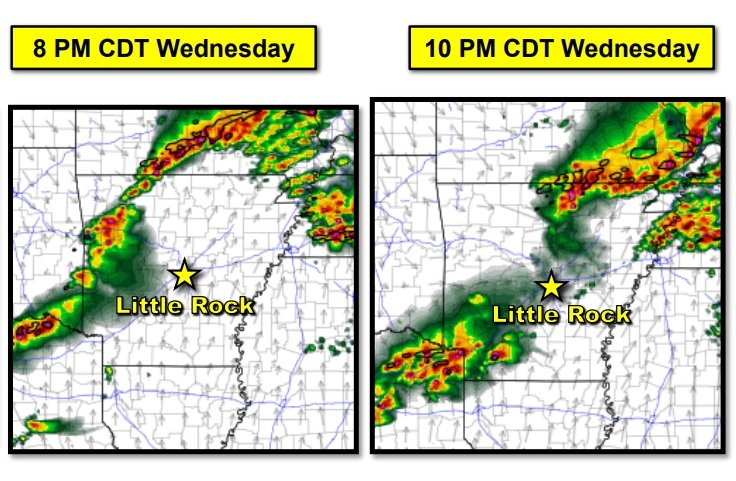
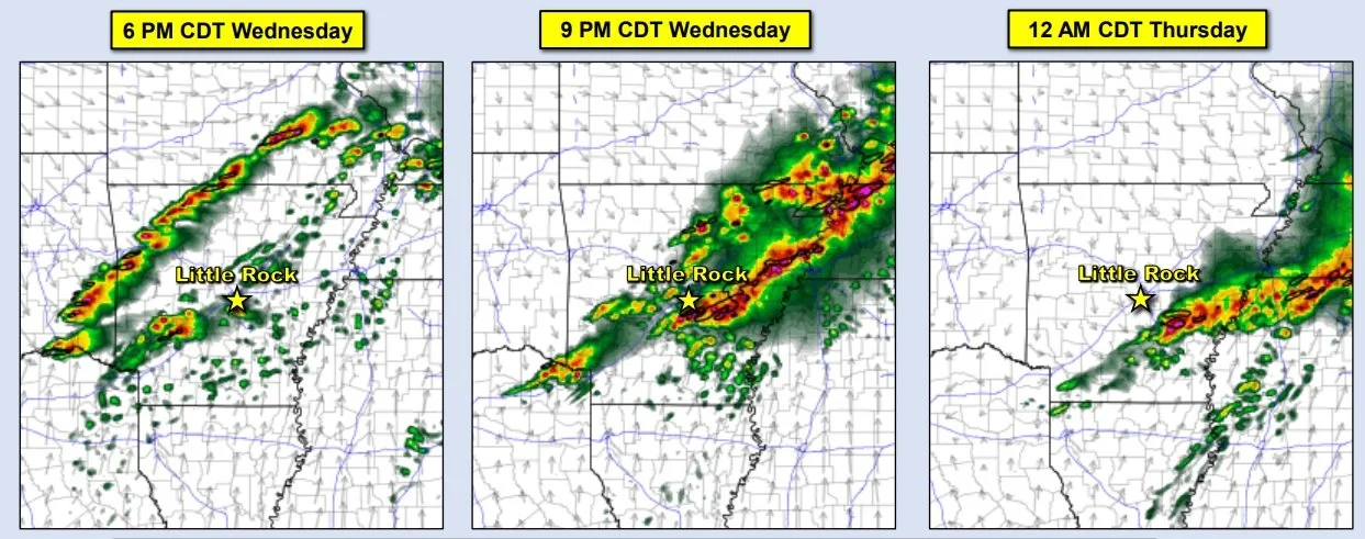
Storms are expected to initially develop by early evening across northern and western Arkansas. These storms will be capable of all severe weather hazards. The storms will gradually shift eastward through the evening hours with the very large hail threat becoming slightly lower. The damaging wind and isolated tornado threat will persist. Activity should make it east of the Mississippi River by daybreak Thursday.

Severe Weather Briefing from the NWS in Little Rock

After activity comes to an end this morning, some additional thunderstorms could develop across central into southeast Arkansas this evening into tonight. But, the severe weather threat with this activity remains low.

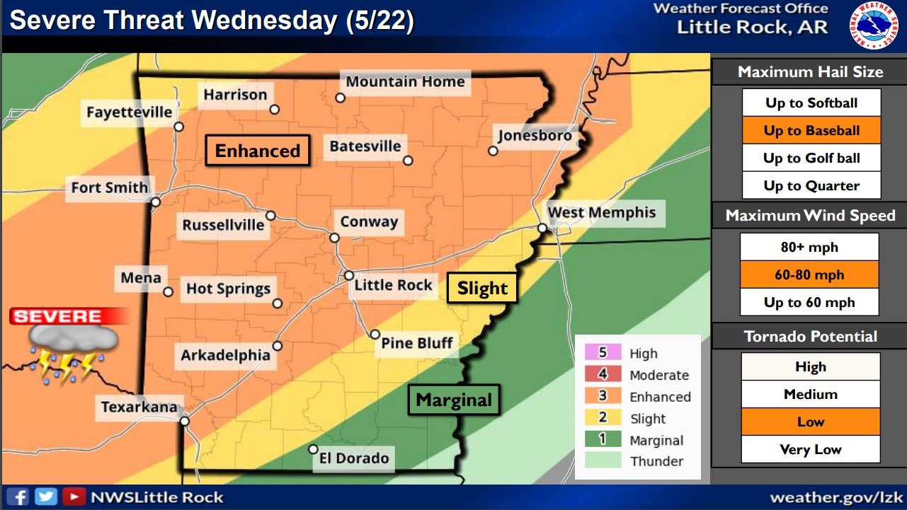
The greatest risk of severe storms in Arkansas will be on Wednesday during the evening into the overnight hours.

Chances for severe weather will increase Wednesday as a storm system tracks from the southern Plains to the mid-Mississippi Valley, and drags a cold front into Arkansas. Ahead of the front, well above average temperatures and humid conditions will create a very unstable environment.

All modes of severe weather are in play. Very large hail up to baseball size and wind gusts up to 80 mph are the main threats, with tornadoes also possible. Heavy downpours may lead to localized flash flooding as well.

Severe Weather Briefing for Arkansas from the National Weather Service in Little Rock

  • There is a potential for severe weather today through Wednesday. The greatest risk of severe storms in Arkansas will be on Wednesday.

  • In the near term, an outbreak of severe weather is expected in the Plains today. A line of strong/severe storms will approach northwest Arkansas tonight, but should weaken as it progresses into the state during the predawn hours Tuesday. Additional isolated to scattered thunderstorms will pop up Tuesday afternoon, but any severe weather will be spotty.

  • Chances for severe weather will increase Wednesday as a storm system tracks from the southern Plains to the mid-Mississippi Valley, and drags a cold front into Arkansas. Ahead of the front, well above average temperatures and humid conditions will create a very unstable environment. All modes of severe weather are in play, including tornadoes. Heavy downpours may lead to localized flash flooding.

Severe Weather Briefing from the NWS Little Rock

  • A northward lifting warm front on Friday, in tandem with an approaching dryline from the west in eastern Oklahoma, will initiate an opportunity for strong to severe thunderstorms to develop and move into Arkansas.

  • All modes of severe weather will be possible from large hail, damaging wind gusts, and a few tornadoes.

  • Excessive rainfall will also accompany this system which will present the risk for flash flooding, especially in vulnerable locations for flash flooding as early as Thursday through Friday night.

National Weather Service Severe Weather Briefing

A cold front will push through Arkansas from the Plains on Thursday. Ahead of the front, very warm conditions/well above normal temperatures will exist, creating a very unstable environment.

A broken line of scattered strong to severe thunderstorms are expected to develop across the northwest counties Thursday afternoon. The line is then expected to move towards central and northeastern locations Thursday evening and night. There are indications the line will gradually weaken after the sun sets, and daytime heating is lost.

Large hail and damaging winds are the primary concerns, especially across northern and extreme western parts of the state. A low, but non-zero tornado chances exists across the northeastern half of the state.

Severe Weather Briefing from the National Weather Service in Little Rock

  • A powerful storm system in the central Plains will drag a cold front towards Arkansas Tuesday afternoon into early Wednesday.

  • Ahead of the front, scattered strong to severe thunderstorms are expected to develop tracking across portions of central and northern Arkansas. Damaging straight-line winds and hail appear to be the primary concern associated with storms Tuesday afternoon.

  • An additional round of severe weather will be possible Thursday across portions of the state. Once again damaging winds and hail will be the primary concern with this system.

Severe Weather Briefing Monday night into Tuesday for Arkansas

  • After a quiet but breezy/warm weekend, a powerful storm system in the central Plains will drag a cold front toward Arkansas late Monday into late Tuesday night.

  • Ahead of the front, scattered strong to severe thunderstorms are expected from portions of Iowa and Nebraska to northern Texas Monday/Monday night. The focus for possible severe weather will shift eastward into Arkansas on Tuesday.

  • Damaging straight-line winds appear the primary thunderstorm hazard across Arkansas, although large hail and a tornado or two will be possible with any supercells that manage to develop ahead of the main line of thunderstorms.

Severe Weather Briefing for Arkansas from the National Weather Service

Strong to severe thunderstorms are still expected to develop late this evening and continue into Monday night. The only real change to the forecast is the computer models continue to slow the progression of the system down.  

The northwest part of Arkansas continues to have the best chances of seeing severe weather with decreasing chances further to the southeast.

  •  Showers and thunderstorms are expected to develop Monday evening and into early Tuesday morning ahead of an approaching cold front. The computer models continue their trend of late in slowing the system down.

  • Some storms are expected to become strong to severe, especially over the northwest half of Arkansas. These locations will have the greatest overlap of severe thunderstorm ingredients Monday evening and into early Tuesday. While all severe weather hazards will be possible, large hail and damaging winds will be the primary concerns and isolated tornadoes will be possible.

  • Large hail and damaging straight-line winds are possible across the rest of the state as well, but chances decrease toward the south and east as the storms are forecast to weaken.

  • Southerly winds gusting upwards of 30 mph will be possible on Monday afternoon and evening.

Severe Weather Briefing for Arkansas on Thursday from the National Weather Service

Scattered strong to severe thunderstorms are expected to develop in eastern Oklahoma this afternoon and move into Arkansas later this afternoon and early evening. These storms will be capable of all severe hazards through later tonight.

The main changes with this briefing include:

-- An expansion of the "Enhanced Risk" area towards northeastern Arkansas

-- The introduction of a 10% Tornado Risk Area over northwestern to northern central Arkansas

Large and damaging hail remains the primary threat with storms today, though all modes of severe weather will be possible today and tonight.

Click on the attached briefing below for more specific forecast information.

Weather Outlook for Arkansas on Thursday from the National Weather Service

A storm system will arrive from the Plains on Thursday and bring showers and thunderstorms to Arkansas Thursday into Thursday night.  

Heavy rainfall, flash flooding, and severe weather will be possible for portions of Arkansas beginning Thursday

Isolated to scattered severe thunderstorms could occur across the western two-thirds of Arkansas Thursday and Thursday night. The main concern will be large hail and damaging winds, however a tornado can not be ruled out. The environment will be most unstable (warm/moist) in the southwest part of the state, and that is where damaging winds, large hail, and a few tornadoes are most favorable.