Heavy Rainfall

Tropical Storm Francine slows harvest, impacts quality for Arkansas crops

By Sarah Cato
U of A System Division of Agriculture

LITTLE ROCK — “It’s going to be a long fall.”

That’s how Cross County Extension Staff Chair Jenna Martin described the agricultural aftermath of Tropical Storm Francine. The storm hit Arkansas last Wednesday, dropping up to 9 inches of rain and crop-damaging gusts of up to 35 miles per hour.

The wind and rain mean that Arkansas row crop growers are facing a longer harvest and lowered quality for rice, cotton, soybeans and corn.

SPROUTED — Many soybean growers in eastern Arkansas are faced with beans sprouted in pods after extensive rainfall from Tropical Storm Francine. (Photo by Christopher Cato.)

“While we’re fairly fortunate compared to some who got a lot more wind, we have some rice and corn leaning and other fields look like you took a flat roller to them,” Martin said. “Impact on yields and quality are major concerns.”

"We received 6 to 7 inches over four days,” said Matthew Davis, Jackson County extension staff chair. “Our largest concerns are the sprouting of crops in the field, loss of quality, and poor field conditions.”

Rice

“There was not as much rice damage as I had feared when I made my way across counties in the northeast yesterday,” said Jarrod Hardke, extension rice agronomist for the University of Arkansas System Division of Agriculture. “There are fields with heavily lodged areas, but the majority of rice is still standing.”

Lodged, or flattened rice takes longer to harvest. This, paired with the yield loss associated with sprouted rice, means rice growers are facing their already thin profit margins shrinking even more.

Hardke said parts of Poinsett, Cross and St. Francis counties seem to have taken the hardest hit.

“In some particular hotspots there is more significant lodging and rice sprouting on heads in the lodged rice,” Hardke said. “To a limited degree there is even some rice sprouting on standing rice.”

Doubling harvest time

“There’s a lot of economic impact to having downed rice,” said Nick Newberry, program associate for the Northeast Rice Research and Extension Center in Harrisburg. “Your harvest time in some situations doubles. The combine’s still rolling and you’re still burning diesel, but the acres you cut in that time is cut in half. If you even had a positive margin to start with, it’s now a break-even or a negative.”

Newberry said they were fortunate to get almost all rice at NERREC cut before the storm.

“Most of what we’ve got left is pretty much flat. It’s not very pretty,” Newberry said. “If this had just come two weeks later it would’ve been better, but that’s the risk you run in this industry.”

Cotton

“The hardest hit areas seem to be around Jackson and Poinsett counties,” said Zachary Treadway, extension cotton and peanut agronomist for the Division of Agriculture. “In these areas it was pretty common to see plants on the ends of rows laying over or at least leaning.”

Treadway said leaning plants should straighten up with time, but for plants completely blown over, those bolls can be expected to rot. As for open cotton bolls, Treadway said most of it is still pickable.

“Of the cotton that is open, I saw a fair amount of fiber drooping out of the bolls, but not a lot on the ground, surprisingly,” he said. “We can still pick that cotton as long as it is hanging on to the bolls.”

However, harvest may be further away than initially anticipated due to field conditions after the rain.

“I expect harvest to be a little delayed now,” Treadway said. “For producers who are ready to pick, they’ll have to wait for the ground to get dry enough to get pickers out in the field. For producers who are defoliating, they’ll either have to wait for the ground to dry enough to get a ground rig across it or hire a pilot to apply defoliants. I think this is going to push everything back.”

However, Treadway said the forecast sunshine will “do us a world of good if it shows up.”

Soybeans

Jeremy Ross, extension soybean agronomist for the Division of Agriculture, said the majority of the damage came in the form of sprouted soybeans.

“I was on the phone with county agents, farmers and crop consultants from the southeast to the northeast corners of the state about soybean seed sprouting in pods,” said Ross said. “Most of these calls are in fields that were ready to harvest prior to Francine, but I had a few calls about pods that are still green having sprouted seeds.”

Fortunately, Ross said this is isolated to just a small portion of pods on the soybean plants.

“Some fields with taller plants that haven’t reached maturity have lodged to some degree,” Ross said. “These fields could have some quality issues due to matted foliage and lack of air movement.”

Ross said the main focus now is to get these fields harvested, but harvesting in wet conditions brings issues of its own.

“We need to get these fields harvested as quickly as possible to avoid additional sprouting and dockage due to moldy seeds. To do this, some fields will need to be harvested before they are dry enough to avoid rutting the fields,” Ross said. “Fields that will be rutted will cost more once they dry out to get back into shape for planting next spring. Some will stay rutted until next spring, delaying planting.”

Corn and grain sorghum

Jason Kelley, extension feed grains agronomist for the Division of Agriculture, said that although corn fields fared better than expected, there was substantial lodging in some areas and grain quality is a concern.

“We’re at the tail end of harvest so the corn that was left had been mature for three to four weeks, with the stalks getting more brittle every day. Every field had some plants blown over,” he said. “Some sprouting of grain in the shuck has occurred and those plants that are laying on the ground will likely see substantial sprouting and loss.”

Kelley said fortunately 84 percent of the state’s corn acres were harvested prior to Francine according to Monday’s crop progress report.  

Although the majority of the state’s few grain sorghum acres had already been harvested, Kelley said there was substantial sprouting of the grain in heads.

“I think the full extent of the damage is still to be seen, especially in terms of grain quality. The level of discounts our growers will receive for reduced-quality grain is the big unknown right now,” Kelley said. “The forecast now looks warm and dry, so harvest will likely start up again in a few days.”

Kelley said wet field conditions and rutting of fields will cause an added expense for this crop.

Forage

There is a bright side to things, as Francine brought much needed rain for livestock and forage producers.

“Much of the state was at least abnormally dry. The rain this past weekend helped to green up fields and provide additional grazing days,” said Kenny Simon, forages instructor for the Division of Agriculture. “Some producers had already started feeding hay, which is about 45 to 60 days ahead of the normal hay feeding period.”

Simon said the rain is especially beneficial for producers that are stockpiling forages or have planted an annual forage.

To learn more about Division of Agriculture research, visit the Arkansas Agricultural Experiment Station website: https://aaes.uada.edu. Follow on Twitter at @ArkAgResearch. To learn more about the Division of Agriculture, visit https://uada.edu/. Follow us on Twitter at @AgInArk. To learn about extension programs in Arkansas, contact your local Cooperative Extension Service agent or visit www.uaex.uada.edu.

Hazardous Weather Briefing from the National Weather Service in Little Rock

  • Heavy rainfall occurred overnight through early Wednesday morning across northern Arkansas which has led to serious flash flooding concerns in some locations

  • Estimated rainfall totals above 10 inches have been observed across portions of Searcy, Stone, Marion and Baxter Counties

  • Additional rainfall is expected today and tomorrow which could worsen ongoing flash flooding

  • Southern Arkansas could see heat index values of 105 or higher this afternoon

  • If you have any flash flooding reports, please pass them along to our office when it is convenient

Tropical Storm Beryl Briefing from the National Weather Service

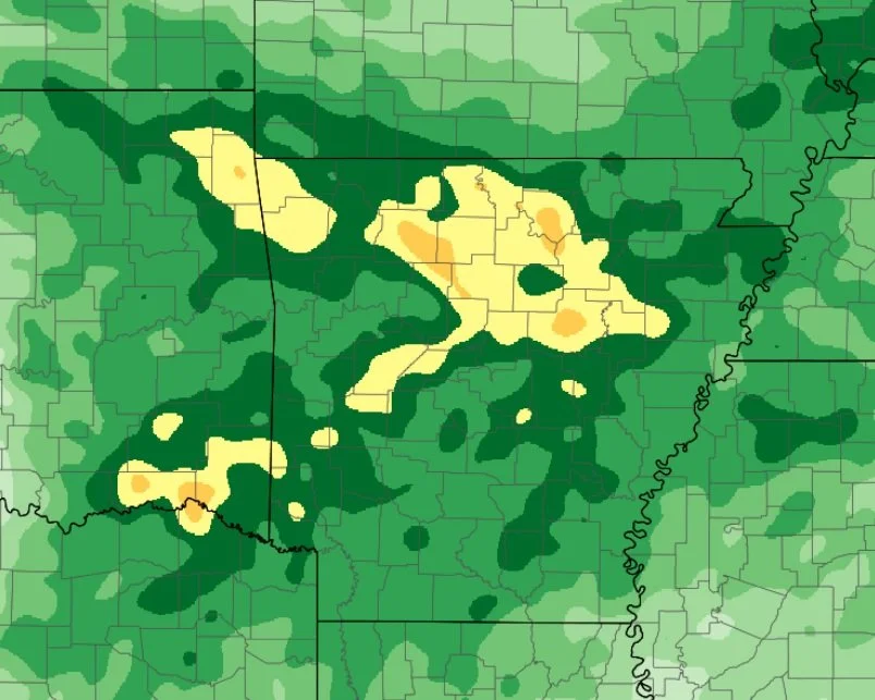
Areas from southwest to north-central Arkansas could see the highest totals (isolated 4-6 inch amounts)

This map shows rainfall totals through Tuesday night, which includes some rainfall expected before Beryl moves through.

  • TS Beryl will move onshore along the Texas coast late tonight into early Monday morning, likely as a hurricane.

  • Beryl will quickly weaken and move toward the north then northeast, traveling across east/northeast Texas Monday into early Tuesday morning.

  • The remnants of Beryl are expected to move across Arkansas from Monday afternoon through Tuesday before lifting northeast of the state by early Wednesday morning.

  • The remnants of Beryl could provide some locally heavy rain and perhaps a few tornadoes/damaging wind gusts across Arkansas from Monday afternoon through Tuesday afternoon.

NOTE: Do not focus on the exact track. Impacts can occur well outside the area enclosed by the cone

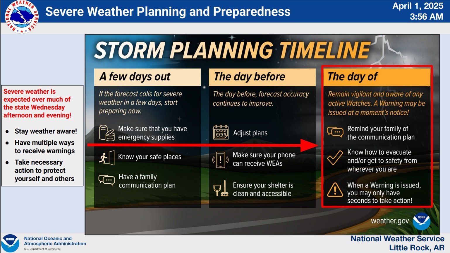
Severe Weather Briefing from the National Weather Service

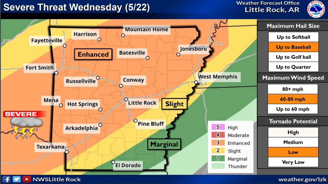
  • A cold front will push through Arkansas beginning on Wednesday morning along the Arkansas/Missouri border in the north and traverse the state moving southward during the day. Strong to severe thunderstorms are likely to be present along this cold front as it moves across the state from north to south.

  • Re-development or rejuvenation of thunderstorm activity will be possible as the cold front moves across central and into southern Arkansas into the early afternoon hours on Wednesday.

  • Damaging wind gusts and large hail are the primary concerns. The tornado threat is very low, but a brief tornado cannot be ruled out.

National Weather Service Hazardous Weather Briefing for Arkansas Tues-Thurs

Severe Threat for Arkansas Late This Afternoon and Tonight - (National Weather Service/Little Rock Graph)

  • An active weather pattern will develop starting late this afternoon and evening as a cold front drops southeast towards Arkansas.

  • Chances for severe weather will increase starting late this evening into the overnight hours across far northwest sections of Arkansas. This threat will spread further southeast for Wednesday, and continue for a large portion of the state on Thursday.

  • The primary threats expected with the strongest storms through tonight will be large hail and damaging winds, with a brief tornado or two possible. Very large hail and damaging winds will be the primary threats on Wednesday, with a few tornadoes also possible. Large hail and damaging winds will again be primary threats for Thursday.

  • There is some uncertainty regarding the severe threat on Wednesday as timing of morning thunderstorms may create less instability for afternoon thunderstorm development.

  • Some areas of heavy rainfall could be seen by late this week. Rainfall amounts exceeding 3 inches could be seen from late tonight through Friday morning. This may lead to some isolated flash flooding.

Severe weather likely in Arkansas beginning Wednesday evening; briefing updated

  • Severe storms are expected to fire across Arkansas this afternoon into the overnight hours.

  • Chances for severe weather will increase through the day as a storm system tracks from the southern Plains to the mid-Mississippi Valley, and drags a cold front into Arkansas. Ahead of the front, well above average temperatures and humid conditions will create a very unstable environment.

  • All modes of severe weather are in play this afternoon and overnight. Very large hail up to baseball size and wind gusts up to 80 mph are the main threats, with tornadoes also possible. Heavy downpours may lead to localized flash flooding as well.

  • On Thursday, storms will be mostly south of Arkansas but could impact far southern portions of the state. Damaging winds and large hail would be the main hazards.

Minor updates have been made by the National Weather Service in Little Rock, AR.

They include the addition of NW Arkansas to the Tornado Outlook and Overnight Timing Graphics. 

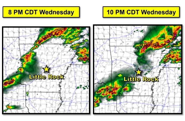
Storms are expected to initially develop by early evening across northern and western Arkansas. These storms will be capable of all severe weather hazards. The storms will gradually shift eastward through the evening hours with the very large hail threat becoming slightly lower. The damaging wind and isolated tornado threat will persist. Activity should make it east of the Mississippi River by daybreak Thursday.

Severe Weather Briefing from the National Weather Service

  • An unsettled weather pattern will continue today/tonight. Showers and scattered thunderstorms remain in the forecast, and areas of heavy rain are expected.

  • The forecast calls for an additional half inch to more than two inches of rain across Arkansas. Spotty flash flooding is possible, and some minor river flooding is likely to occur or is ongoing.

  • While the primary concern will be heavy rain, there could be isolated severe storms across southern Arkansas. More significant severe weather is likely farther south along the Gulf Coast (from Louisiana into Mississippi and Alabama).

Severe Weather Briefing from the National Weather Service

There will be a brief window for severe weather Monday afternoon and evening over the south and southeast parts of the state. While there will be a lot of wind energy with this system, instability is low which will keep the severe threat limited. 

Windy conditions are expected to develop before the actual system arrives and some parts of the state may see some locally heavy rain.

  • We continue to monitor a strong cold front that will be moving across the state Monday into Monday evening. Sustained winds of 20 to 30 mph are expected with higher gusts possible outside of any thunderstorm activity.

  • Strong gusty winds remain the primary threat with storms on Monday. While the tornado threat is minimal, it is not zero.

  • The greatest overlap of severe thunderstorm ingredients will lie over southern and southeastern Arkansas Monday afternoon and evening. While there is a tremendous amount of wind energy with this system, instability is limited.

  • Widespread rain is expected before the actual cold front arrives which will further decrease the chance of widespread severe weather.

  • In addition to severe weather, localized heavy rainfall is possible, primarily over the western half of the state. Some localized flash flooding issues may arise as a result.

Arctic Air blasts Arkansas this weekend; freezing rain and heavy rainfall early next week

From the National Weather Service in Little Rock

Arctic air is arriving from the Plains Friday morning. A gusty northwest wind will produce wind chill index values from zero to ten below zero in the northern two to three rows of counties in Arkansas. 

Below to much below normal temperatures will continue through the weekend. Saturday will be the coldest day, with lows in the single digits and teens and highs in the 20s and 30s. Minimum wind chill indices will be in the single digits above and below zero Friday night into Saturday morning. 

Late Sunday night and Monday, Arctic air will begin exiting to the east. Clouds and moisture will increase, with rain developing. Precipitation will likely start off as freezing rain, with the potential for at least a tenth of an inch of ice in northern/western sections of the state. 

Rain will continue through at least Thursday. The forecast calls for one to more than three inches of rain across the region, with the heaviest amounts over the southern counties.

Rains likely to hurt Arkansas’ rice crop

by George Jared (gjared@talkbusiness.net)

Recent perpetual rains may have a significant impact on Arkansas rice as the crop inches closer to harvest. Northeast Arkansas farmers have been checking their fields for losses after storms late last week and this weekend dumped more than 6 inches of rain in places.

Coming into the week, the National Agricultural Statistics Service listed Arkansas’ rice crop at 10% mature, well ahead of the five-year average of 5%. Rice was 74% headed compared with the five-year average of 65%.

Jackson, Independence, Izard, Searcy and Stone counties were among the hardest hit by the storms, according to the National Weather Service.On social media, farmers reported between 4-8 inches in Independence County and 5-6 inches in Poinsett County.

https://talkbusiness.net/2023/08/rains-likely-to-hurt-arkansas-rice-crop/

Severe Weather Briefing for Wednesday evening from the National Weather Service in Little Rock, AR

Toward evening, a strong storm system and associated cold front will approach from the Plains. A new round of strong to severe thunderstorms will likely develop in southern Missouri and sweep into northern Arkansas.

This could be a significant severe weather event, and somewhat unusual for August. This kind of event is more reminiscent of spring. Destructive winds and large hail are the main concerns, and an isolated tornado or two are possible. 

Torrential downpours are expected in places. The forecast calls for two to three inches of rain in parts of the north, and this may result in localized flash flooding. 

National Weather Service
Little Rock, Arkansas

Heavy rain in southern Arkansas KO’s hay production, closes roads

LEWISVILLE, Ark. — Heavy rain in southwest Arkansas closed roads and brought hay production to a halt in Lafayette County, said Jerri Dew, the county’s extension staff chair, said on Thursday.

A stalled front enabled rain to continue falling over the same area starting overnight Tuesday into Wednesday morning. The National Weather Service at Shreveport, Louisiana, which covers parts of southwest Arkansas, issued a flash flood emergency for portions of Columbia, Hempstead, Lafayette and Nevada counties and warned of life-threatening flash flooding “particularly in the Stamps, Bucker, Lewisville and Patmos areas.”

Flood damage to Arkansas Highway 98 in southern Arkansas. (Image courtesy Arkansas Department of Transportation)

According to the National Weather Service, northern Lafayette County saw the highest totals, estimated at 6-8 inches. A CoCoRaHs station — Community Collaborative Rain, Hail and Snow network — recorded 7 inches in Hempstead County. El Dorado, in Union County, recorded 4 inches, which was a record total for July 12. The old record of 2.6 inches was set in 2002.

“The flooding yesterday was not as bad in most of the cropland — for once — as it was in the northeast corner of the county which is mostly timber, some hay,” Dew said. “It was a mess up here. A lot of flooding.”

Roads closed

“U.S. Highway 82 was even closed for a time due to complete flooding,” she said, adding that she couldn’t remember that happening before.

According to the Arkansas Department of Transportation, both lanes of Arkansas 98 remained closed Thursday because of a washout. The department tweeted an image of damage to the highway.

“My neighbor keeps weather data for Lamartine and he had 12.77 inches of rain in his electronic rain gauge within a 12-hour span yesterday morning,” Dew said. “We have a lot of road damage over there.”

Crop damage

Dew that in visiting one of the farmers in the bottoms, he told her he didn’t get as much rain as the northern part of the county, but Wednesday’s rain added to the effects of previous events.

Road crew in Columbia County repairing damage following heavy rain on Wednesday (U of A System Division of Agriculture photo by Jerri Dew)

“They have had one storm after another come through for weeks now,” she said. “A lot of corn has been blown down, there has been a lot of hail damage and water is standing in the fields. Dew said that in driving through the area on Tuesday, she “observed a lot of yellowing corn. I am sure water is the majority of the problem.”

“Hay production has come to a standstill,” she said. “There are hayfields from one end of the county to the other that needed to be cut three weeks ago. Producers cannot catch a break to cut because we have showers almost daily.

“It is mid-July and some producers have not completed their second cutting yet. It is all adding up to make a short year on hay and a lot of it is not going to be good quality,” Dew said.

The Cooperative Extension Service is the outreach arm of the University of Arkansas System Division of Agriculture.

To learn about extension programs in Arkansas, contact your local Cooperative Extension Service agent or visit www.uaex.uada.edu. Follow us on Twitter and Instagram at @AR_Extension. To learn more about Division of Agriculture research, visit the Arkansas Agricultural Experiment Station website: https://aaes.uada.edu/. Follow us on Twitter at @ArkAgResearch. To learn more about the Division of Agriculture, visit https://uada.edu/. Follow us on Twitter at @AgInArk.

A risk of severe weather for Arkansas on Friday

A strong storm system will be in the central United States on Friday. Ahead of the system, a strong south wind will bring warm temperatures and increasing moisture, and the potential of strong to severe thunderstorms. 

There is some question as to how much warmth/moisture (instability) will be in place as thunderstorms develop. Also, the system/associated energy will be well north of the state, and this may limit the amount of severe weather that occurs. The situation will be monitored closely. 

Quarter to three quarter inch precipitation totals are in the forecast. This will not be enough to make existing high water issues (elevated rivers/saturated soil) worse.

Severe Weather to affect Arkansas Wednesday and Thursday

An active weather pattern is underway with the first round of severe weather expected this afternoon through tonight. An additional round of heavy rain and severe thunderstorms are expected Thursday afternoon through the early morning hours on Friday. Severe weather types include damaging winds, large hail, and tornadoes.

The threat for flash flooding will increase across the central and northern portions of the state over the next few days.

Please see the attached briefing for more details.

National Weather Service in Little Rock, AR

Severe weather in Arkansas includes possible flooding, thunderstorms, severe weather and tornadoes

The Slight Risk area for severe weather has been expanded to include all of southern, central, and most of eastern Arkansas.

  • The Flood Watch has been expanded to include all of western, northern, and much of central/northeastern Arkansas.

  • Forecast rain amounts were increased with widespread totals of 2 to 4 inches likely over the northwestern half of the state. Localized totals of 5 or more inches will be possible.

  • A Wind Advisory will go into effect this evening through Thursday morning for all of eastern Arkansas. Sustained winds of 20 to 30 mph and gusts to 40 mph are likely.

  • Showers and storms will continue along and north of I-30/I-40 through early afternoon with coverage expanding across the remainder of the state afternoon into evening.

    • Rain will be heavy at times with a continued threat for flash flooding, mainly over the northwestern half of Arkansas.

    • The threat for severe weather will increase by the afternoon along and south/east of I-30/I-40. Damaging winds and isolated tornadoes will be possible with a lesser threat for severe hail.

    • Activity will taper off west-to-east overnight with most precipitation gone before daybreak Thursday

Increased Threat of Severe Weather Friday Evening in Arkansas

A fairly major update has been made to the severe weather forecast through tonight. Here are the main points: 

Moderate Risk introduced for all of western, southwestern AR

- Increased threat for tornadoes, some potentially significant, in and near southwest 

  AR. Damaging hail is also possible.

- Intense winds (up to 70-80 mph) possible as storms move across AR late evening 

  and overnight

Enhanced Risk expanded to include the southern half of AR.

Onset timing remains the same (5-7 PM), but storms will move across AR faster than previously thought with storms moving east of the MS River by 3-4 AM.

The attached briefing contains updated graphics pertaining to the severe threat and timing. 

Potential for Damaging Winds, Storms, Heavy Rainfall, and Possible Tornadoes for Friday

A storm system will approach the Natural State on Friday afternoon and complete its progression across the state by early Saturday morning. Click on the link above for a briefing outlining this event.

More storms and heavy rainfall on the way for Arkansas followed by hot and humid conditions next week

From the National Weather Service In Little Rock:

--Another complex of strong to severe storms is expected to move through the forecast area as soon as the early morning hours on Friday, extending into the daytime on Friday. The main hazards of this storm system would be damaging winds and large hail.  

--Where storms move over the same locations repeatedly, the risk for flash flooding will increase given wet antecedent conditions of late. Additional heavy rainfall over swollen smaller tributaries will keep local river levels elevated as well. 

--Heading into next week, hot, humid, and oppressive conditions are expected to ensue, with hazardous heat index values possible as early as Monday. 

As always, tune into your local National Weather Service forecast offices for the latest updates.

Click on the pic below for the latest weather brief from the NWS.

Heavy Rainfall and Flooding Expected for Arkansas on Tuesday

A heavy rain event is expected for Tuesday and Wednesday in Arkansas, but it appears the amounts will not be quite as heavy as previously thought. 

The forecast calls for three to four inches of rain (instead of four to six inches) from central into southwest Arkansas. Elsewhere across the state, one to three-inch amounts is expected. Given this much rain, there is the potential for flash flooding in places and rises in area rivers.

Click on the pic below for the attached weather briefing PDF from the National Weather Service.

Severe Weather Briefing for Arkansas from the National Weather Service in Little Rock

[TODAY] A strong storm system will be approaching the region through today, providing the next widespread thunderstorm chances on Thursday. In between now and then, a stalled boundary draped across the state will remain the focus for intermittent showers and thunderstorms today. 

[THURSDAY] Our next main concern for organized severe weather will set up on Thursday as a cold front moves across the state from west to east. All severe hazards will be possible including damaging winds, some hail, and a few tornadoes. 

[ADDITIONAL HAZARDS] Heavy to excessive rainfall and local flash flooding will remain a concern today and Thursday, given multiple rounds of precipitation have led to widespread saturated regions. 

Please click on the pic below to see the attached briefing for more information.