Flooding

Sanders Signs Executive Order to Provide Relief for Severe Storms, Tornadoes, and Flooding on or About April 2, 2025

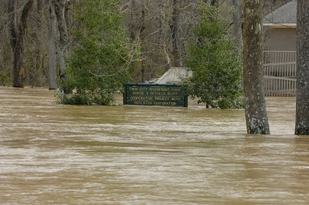
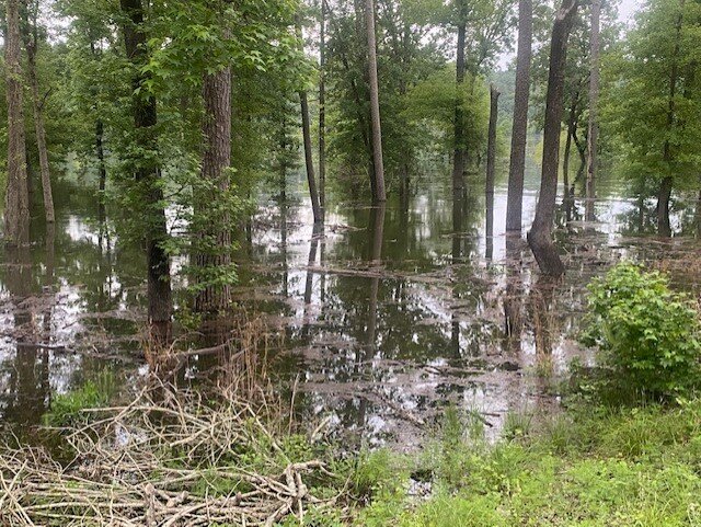
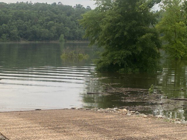
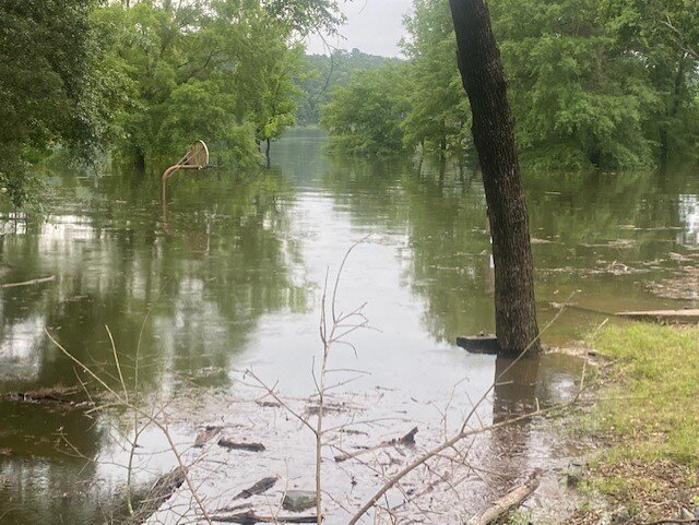
Scene of flooding in Arkansas, April 6-7, 2025. (Division of Agriculture image.)

TO ALL TO WHOM THESE PRESENTS COME – GREETINGS:    
     
                 
EO 25-08: EXECUTIVE ORDER TO PROVIDE RELIEF PURSUANT TO THE EMERGENCY DECLARED IN EXECUTIVE ORDER 25-07. 

WHEREAS:​ On April 2, 2025, severe storms, flooding, and tornadoes began in Arkansas, and continue to cause danger, hardship, and suffering throughout the state; 

WHEREAS: Adverse circumstances have been brought to bear upon citizens and public properties within the State of Arkansas and certain political subdivisions require assistance from the state to recover from these losses;

WHEREAS: On April 2, 2025, by Executive Order 25-07, a state of emergency was declared in Arkansas as a result of the severe weather outbreak, pursuant to the Emergency Services Act, codified at Ark. Code Ann. §§ 12-75-101, et seq.

WHEREAS: Ark. Code Ann. § 12-75-114(e)(1) authorizes the Governor to suspend any regulatory statutes if compliance with those statutes would delay action in coping with the declared emergency;

WHEREAS: Ark. Code Ann. § 26-18-505 authorizes the Secretary of the Department of Finance and Administration to grant a reasonable extension of time to file any return required under any state tax law upon written request for good cause shown. Good cause includes when any taxpayer is affected by a disaster emergency declared by the Governor; and

WHEREAS: Strict compliance with certain statutes would hinder necessary action in coping with the emergency in the following affected counties:

Arkansas CountyAshley CountyBaxter CountyCalhoun CountyChicot CountyClark CountyClay CountyCleveland CountyColumbia CountyConway CountyCraighead CountyCrawford CountyCrittenden CountyCross CountyDallas CountyDesha CountyDrew CountyFaulkner CountyFranklin CountyFulton CountyGarland CountyGrant CountyGreene CountyHempstead CountyHot Spring CountyIndependence CountyIzard CountyJackson CountyJefferson CountyLafayette CountyLawrence CountyLee CountyLincoln CountyLittle River CountyLonoke CountyMarion CountyMiller CountyMississippi CountyMontgomery CountyNevada CountyNewton CountyOuachita CountyPerry CountyPhillips CountyPike CountyPoinsett CountyPolk CountyPope CountyPrairie CountyPulaski CountyRandolph CountySaline CountyScott CountySearcy CountySebastian CountySevier CountySharp CountySt Francis CountyStone CountyUnion CountyVan Buren CountyWhite CountyWoodruff County

NOW THEREFORE, I, SARAH HUCKABEE SANDERS, acting under the authority vested in me as Governor of the State of Arkansas and pursuant to Ark. Code Ann. §§ 12-75-101, et seq., and the state of emergency declared in Executive Order 25-07, do hereby order the following:

  1. The Secretary of the Department of Finance and Administration is hereby ordered to extend the 2024 income tax filing date and income tax payment date and 2024 pass through entity tax filing date and pass-through entity tax payment date from April 15, 2025, to July 31, 2025, for those citizens who reside or whose businesses are located in the affected counties. This extension includes 2024 returns of Individuals, Subchapter S Corporations, C Corporations, Pass-Through Entities, Fiduciaries and Estates, Partnerships, and Composite returns.

  2. Individuals and entities in the affected counties will have until July 31, 2025, to file income tax and pass-through entity returns and pay income and pass-through entity taxes that were originally due between April 2, 2025, and July 31, 2025.

  3. This relief includes return and extension payments due between April 2, 2025, and July 31, 2025.

  4. The Secretary of the Department of Finance and Administration is hereby ordered to extend the deadline under Ark. Code Ann. § 26-51-913(a)(2) to make a quarterly estimated income tax payment between April 2, 2025, and June 30, 2025, for those citizens and businesses located in the affected counties to July 31, 2025.

  5. The Secretary of the Department of Finance and Administration is hereby ordered to extend the deadline under Ark. Code Ann. § 26-65-107(b)(1) to make a quarterly estimated pass-through entity tax payment between April 2, 2025, and June 30, 2025, for those citizens and businesses located in the affected counties to July 31, 2025.

  6. The provisions of Ark. Code Ann. § 26-18-505(a)(1) requiring a written request for an extension to file an individual income tax return are hereby waived through July 31, 2025, for citizens who reside or whose businesses are located in the affected counties.

  7. The provisions of Ark. Code Ann. § 26-18-505(a)(4) requiring the promulgation of rules to waive the requirement for a written request for an extension are hereby waived through July 31, 2025. 

  8. The provisions of Ark. Code Ann. § 27-16-805 and § 27-16-806 requiring payment of a fee for a duplicate driver’s license, instruction permit, or identification card are hereby waived for citizens who reside in the affected counties from the date of this order through July 31, 2025.

  9. The provisions of Ark. Code Ann. § 27-14-705(e) requiring payment of a $10.00 fee for expedited title processing service are hereby waived for affected citizens who reside in the affected counties from the date of this order through July 31, 2025.

  10. The provisions of Ark. Code Ann. § 26-18-508 and § 26-52-510(a)(4) assessing interest and penalty for failure to timely register a vehicle are hereby waived for citizens who reside in the affected counties from the date of this order through July 31, 2025.

  11. The provisions of Ark. Code Ann. § 27-14-1004(a) assessing penalty for failure to timely register a vehicle or renew a vehicle registration are hereby waived for citizens who reside in the affected counties from the date of this order through July 31, 2025.

IN TESTIMONY WHEREOF, I have hereunto set my hand and caused the Great Seal of the State of Arkansas to be affixed on this 11th day of April, in the year of our Lord 2025.

Hunters, anglers urged to use caution accessing remote areas

This washed-out road at Petit Jean River WMA is indicative of some of the damage seen throughout the state during last week’s epic rain event. AGFC photo.

The road crossing this set of culverts on H. E. Alexander WMA has narrowed considerably from a washout, and caution is advised when encountering this sort of condition when hunting. AGFC photo.

LITTLE ROCK — The Arkansas Game and Fish Commission is still assessing much of the damage from five days of rain and storms that dumped more than 2 feet of water in some portions of The Natural State. The AGFC asks hunters and anglers to exercise additional caution when driving to their favorite turkey hunting location or boat ramp this spring.

The AGFC’s Special Youth Turkey Hunt is Saturday and Sunday, April 12-13. The regular statewide turkey season begins Monday, April 21.

Damage at Jim Hinkle Spring River Hatchery was extensive. AGFC photo.

“We know there are still some roads underwater right now that will block access to some wildlife management areas, and we’re still receiving reports on county roads and roads within WMAs that have been washed out or otherwise compromised to vehicle traffic,” AGFC Operations Division Chief Mike Cantrell said. “All of our areas will remain open for turkey season and other access so that people can enjoy the outdoors and reengage with nature, but please be patient and observant as downed trees, washouts and other dangers may be present until our crews and various partner agencies have a chance to address them.”

Downed power lines, a collapsed railroad bridge and extensive erosion contribute to safety concerns at Spring River facilities following last week’s storms. AGFC photo. 

Cantrell also warns that water levels still have not crested on some of Arkansas’s major rivers, and additional areas may experience flooding, particularly in the southern half of the state. Visit this link to view the National Water Prediction Service’s map of existing river gauges and flood predictions.

The Jim Hinkle Spring River State Fish Hatchery at Mammoth Spring is one AGFC-owned area that will be temporarily closed as agency staff work to rebuild the road leading to the hatchery and assess the damage caused by the flood.

“The hatchery did flood, and we are still getting a bearing on the extent of the damage,” Cantrell said. “We appreciate everyone’s understanding and patience as we work to make these areas safe again. Please stay safe and stay away from the Spring River State Fish Hatchery and Dam 3 Access to the Spring River area until further notice. We will provide updates on the situation as they become available.”

President Trump Approves Arkansas’ Emergency Request Amid Flooding

LITTLE ROCK, Ark. – Governor Sarah Huckabee Sanders announced that President Trump has approved Arkansas’ request for an Emergency Declaration for Direct Federal Assistance to assist Arkansas with the state response to storms, tornadoes, and flooding that began on April 2, 2025, and is ongoing. Arkansas is already experiencing flooding after last night’s rainfall and of particular concern are the Buffalo River, Spring River, Little Red River, Cache River, Black River, Saline River, Ouachita River, Eleven Point River, Mississippi River, Petit Jean River, Little River, and White River. 

The Governor’s letter to the President is linked here.

“I’m so thankful to President Trump for always jumping into quick action and ensuring the American people are safe and taken care of. We appreciate his administration’s proactive response to this storm,” said Governor Sanders. “With these additional federal resources, Arkansas will have the capacity to respond to this flooding more effectively, shore up property and roadways, and save lives.”

Arkansas is specifically receiving:

  • Category B, limited to Direct Federal Assistance, statewide

White River Flooding - NARA & DVIDS Public Domain

Serial storms in Arkansas ramp up residents’ anxiety, create flooding and danger

From the Arkansas Advocate:

Willadean Hergott of Jonesboro clutched a stuffed toy monkey while sitting in the Craighead County safe room in Jonesboro Friday evening and waited for the next round of storms.

“I don’t like tornadoes. I don’t like seeing what happened in Lake City,” she said, referring to a twister that smashed the western edge of the Craighead County town Wednesday evening with winds of 150 mph.

“You never know anymore where one will come up,” she said.

Hergott sat in a chair inside the shelter, which has a capacity for 600 people. She said she had the monkey for her grandchildren who would show up shortly.

Serial storms in Arkansas ramp up residents’ anxiety, create flooding and danger

National Weather Service Little Rock

The past several days of heavy rains engorged streams and rivers across Arkansas. This National Weather Service map forecasts flood stage at various points along major rivers

Forecast with massive rain may mean planting do-overs for Arkansas farmers

By Mary Hightower
U of Arkansas System Division of Agriculture
April 2, 2025

LITTLE ROCK — As forecasts call for up to 10 inches of rain through Sunday, the immediate future for Arkansas farmers will probably involve clearing ditches, with a good likelihood next week will be taken up with replanting and reworking fields, extension specialists said.

Planting of the state’s commodities has begun, with Monday’s Crop Progress report from the U.S. Department of Agriculture showing 22 percent of the state’s corn crop planting and 3 percent already emerged.  Rice was 8 percent planted and 1 percent emerged. Soybeans were 5 percent planted. Winter wheat, usually harvested in summer, was 11 percent headed.

While rain is usually a welcome event, the expected deluge can wash away plant beds and any newly emerged seedlings.

PICRYL Image

“I’ve been telling guys to hold off,” said Jeremy Ross, extension soybean agronomist for the University of Arkansas System Division of Agriculture.  “We’ll probably need to repull beds that have been freshly pulled.”

The National Weather Service issued a flood watch for much of the state through April 6.

“There’s not much you can do with that much rain in a short amount of time,” said Scott Stiles, extension economics program associate for the Division of Agriculture. “You want to have all the ditches and pipes open.”

In northeastern Arkansas, “everybody around here has water furrows run — a good effort on drainage,” Stiles said.

“Backing up of the rivers, streams and bayous will be the story,” said Jarrod Hardke, rice extension agronomist for the Division of Agriculture. “Low ground that’s already planted may be wiped out regardless of the crop planted there.”

Hardke said “rice will survive the best, but levees will be the issue. They’ll get washed out and blown and have to be repulled and reseeded.

“Recently planted corn and soybean are in for a wild ride for survival,” he said. “Cool temperatures may help buy them some time but staying flooded or saturated for four-plus days is a bad recipe for emerged seedlings and fresh planted seed.”

The cotton and peanut growers, with their later planting dates, might dodge a bullet.

“We haven’t begun to plant yet,” said Zachary Treadway, extension cotton and peanut agronomist for the Division of Agriculture. “If we end up getting all the rain they’re calling for, we could see delays, either from extremely wet ground that takes a long time to dry, and/or replants taking priority.

Crop insurance considerations

Stiles said that for crop insurance purposes April 1 is the earliest planting date for rice, with April 15 being the earliest planting date for soybeans.

“Rice or soybeans that have already been planted are not eligible for replant payments from crop insurance,” he said.

To learn about extension programs in Arkansas, contact your local Cooperative Extension Service agent or visit www.uaex.uada.edu. Follow us on X and Instagram at @AR_Extension. To learn more about Division of Agriculture research, visit the Arkansas Agricultural Experiment Station website: https://aaes.uada.edu/. Follow on X at @ArkAgResearch. To learn more about the Division of Agriculture, visit https://uada.edu/. Follow us on X at @AgInArk.

Updated Weather Briefing from the National Weather Service

  • WHAT HAS CHANGED: The Flood Watch has been expanded to include portions of northern central Arkansas.

  • A strong storm system will approach the state from the southwest through the day today, and rainfall will become widespread from west to east across the area later this evening through Thursday.

  • As the system moves through, excessive rainfall is possible from southeast Oklahoma across portions of western and northern Arkansas, resulting in increasing flash flooding potential. Area rivers and basins are also expected to see an increase in streamflow, with some locations possibly reaching flooding levels.

  • Additionally, a few strong to severe thunderstorms are possible across mainly southern Arkansas Thursday afternoon and evening.

  • The threat for hazardous weather is expected to come to an end by Friday morning as the storm system moves east of the state.

The greatest probabilities for rainfall in excess of 3 inches currently lies across portions of western to central Arkansas, and primarily over the high terrain regions. A large probability exists for much of the northwestern half of the state to receive at least 2 inches of rainfall.

Governor Sanders signs an executive order to provide additional relief in regards to tax filing and payment deadlines in response to the May 24th storms in Arkansas

TO ALL TO WHOM THESE PRESENTS COME – GREETINGS: 

E.O. 24-11: EXECUTIVE ORDER TO AMEND E.O. 24-09 AND PROVIDE ADDITIONAL RELIEF IN REGARD TO TAX FILING AND PAYMENT DEADLINES IN RESPONSE TO SEVERE STORMS ON OR ABOUT MAY 24, 2024. 

Wikimedia Image

WHEREAS: On or about May 24, 2024, and continuing, severe storms, flooding, and tornadoes began in Arkansas, causing danger, hardship, and suffering which now warrants this executive action; 

WHEREAS: On May 26, 2024, by Executive Order 24-07, a regional emergency was declared in the state as a result of the severe weather outbreak, pursuant to the Emergency Services Act, codified at Ark. Code Ann. §§ 12-75-101, et. seq; 

WHEREAS: Ark. Code Ann. § 26-18-505 authorizes the Secretary of the Department of Finance and Administration to grant a reasonable extension of time to file any return required under any state tax law upon written request for good cause shown. Good cause includes when any taxpayer is affected by a disaster emergency declared by the Governor; 

WHEREAS: Ark. Code Ann. § 12-75-114(e)(1) authorizes the Governor to suspend any regulatory statutes if compliance with those statutes would delay action in coping with the declared emergency; 

WHEREAS: On May 30, 2024, by Executive Order 24-09, relief was extended to affected citizens in Baxter, Benton, Boone, Carroll, Fulton, Grant, Greene, Madison, Marion, Nevada, Randolph, Sevier, and Sharp counties by extending certain tax payment deadlines; and 

WHEREAS: There is good cause for additional relief to be extended to Arkansans residing in Baxter, Benton, Boone, Carroll, Fulton, Grant, Greene, Madison, Marion, Nevada, Randolph, Sevier, and Sharp counties as a result of the ongoing emergency. 

NOW THEREFORE, I, SARAH HUCKABEE SANDERS, acting under the authority vested in me as Governor of the State of Arkansas and pursuant to Ark. Code Ann. §§ 12-75-101, et seq., issue this Executive Order pursuant to the regional emergency as declared in Executive Order 24-07, and order the following: 

1. The Secretary of the Department of Finance and Administration is hereby ordered to extend the 2023 income tax filing date and income tax payment date and 2023 pass-through entity tax filing date and pass-through entity tax payment date for returns that are due between May 24, 2024, and October 31, 2024, to November 1, 2024, for those citizens and businesses residing in Baxter, Benton, Boone, Carroll, Fulton, Grant, Greene, Madison, Marion, Nevada, Randolph, Sevier, and Sharp counties. This extension includes 2023 returns of Individuals, Subchapter S Corporations, Subchapter C Corporations, Pass-Through Entities, Fiduciaries and Estates, Partnerships, and Composite returns; 

2. Individuals and entities in Baxter, Benton, Boone, Carroll, Fulton, Grant, Greene, Madison, Marion, Nevada, Randolph, Sevier, and Sharp counties will have until November 1, 2024, to file income tax and pass-through entity returns and pay income and pass through entity taxes that were originally due between May 24, 2024, and October 31, 2024; 

3. This relief includes return and extension payments due between May 24, 2024, and October 31, 2024; 

4. The Secretary of the Department of Finance and Administration is hereby ordered to extend the deadline under Ark. Code Ann. § 26-51-913(a)(2) to make a quarterly estimated income tax payment from between May 24, 2024, and October 31, 2024, for those citizens and businesses located in Baxter, Benton, Boone, Carroll, Fulton, Grant, Greene, Madison, Marion, Nevada, Randolph, Sevier, and Sharp counties to November 1, 2024; 

5. The provisions of Ark. Code Ann. § 26-18-505(a)(1) requiring a written request for an extension to file an individual income tax return are hereby waived through November 1, 2024, for citizens who reside or whose businesses are located in Baxter, Benton, Boone, Carroll, Fulton, Grant, Greene, Madison, Marion, Nevada, Randolph, Sevier, and Sharp counties; 

6. The provisions of Ark. Code Ann. § 26-18-505(a)(3) limiting an extension for filing an individual income tax return to no more than 180 days is hereby waived through November 1, 2024, for citizens who reside or whose businesses are located in Baxter, Benton, Boone, Carroll, Fulton, Grant, Greene, Madison, Marion, Nevada, Randolph, Sevier, and Sharp counties; and 

7. The provisions of Ark. Code Ann. § 26-18-505(a)(4) requiring the promulgation of rules to waive the requirement for a written request for an extension are hereby waived through November 1, 2024. 

IN TESTIMONY WHEREOF, I have hereunto set my hand and caused the Great Seal of the State of Arkansas to be affixed on this 15th day of July, in the year of our Lord 2024.

Severe weather risk for Arkansas Thursday and Friday

A strong storm system is expected to bring showers and thunderstorms to the state Thursday through Friday night. Some of these storms could become strong to severe. In addition to the threat for severe weather, there is also a threat for flooding due to the expected heavy rainfall. Please see the attached briefing for more details.

There is a Marginal Risk for severe thunderstorm late on Thursday into early Friday, along and mainly north of our I-30 corridor. Damaging winds and large hail will be the primary threats and locally heavy rainfall could bring isolated flash flooding.

Locally heavy rainfall from a line of strong to possibly severe thunderstorms, could result in isolated flash flooding late Thursday into early Friday with the Slight Risk north of our I-30 corridor.

A line of strong to severe storms will continue across the area during early Friday with afternoon heating firing up a Slight Risk for severe storms in deep E TX, all of our Parishes and south central AR during the afternoon. Damaging winds and large hail will be the primary threats and locally heavy rainfall could bring isolated flash flooding.

As rainfall patterns become more extreme, pasture managers will need to become increasingly proactive

By the U of A System Division of Agriculture 

FAYETTEVILLE, Ark. — Average temperatures in Arkansas have risen about 0.5 degrees over the past two decades, according to the North Carolina Institute for Climate Studies. One result of this has been more extreme patterns of rainfall and drought. Dirk Philipp, associate professor of forage agronomy for the University of Arkansas System Division of Agriculture, said these changes in rainfall patterns typically have a variety of effects — particularly on agriculture.

DELUGED — Heavy rainfall can take a toll on pastures not equipped to manage runoff. (Image courtesy Dirk Philipp.)

Based on current climate and weather patterns, Philipp said, these weather extremes may include increased rainfall intensity and extended periods of both higher and lower rain frequency, leading to flooding and drought, respectively — and these changes in rainfall patterns typically have a variety of effects.

“For example, increased intensity means the rain has a higher impact on soil, which equates to higher erosion potential,” he said. “There’s a higher potential for runoff and dislodging soil particles.”

Philipp said changes in rainfall patterns may also lead to decreased rainwater infiltration rates, meaning the soil itself will retain less moisture and aquifers will be slower to recharge. And because evaporation rates are high in the southeastern United States, droughty periods will be relatively more severe for plants in that region than in higher latitudes where incoming solar rays are less powerful.

“Changing rainfall patterns also have biological effects,” Philipp said. “Planting times are affected, because fields may be wetter or drier than in the past during the usual planting times.”

All of this will put stress on existing forage stands and will have implications for establishing new stands as well, Philipp said. To make pastures more resilient in the long term, he has several key suggestions.

“Buffer strips in strategic locations go a long way in capturing runoff and helping to infiltrate it into the soil,” he said. “Extended riparian areas will also achieve that. Buffers around 50-100 feet wide can be grazed, as well.”

Philipp said pasture managers should be conscious of the topography of their land, and should consider reforesting areas that were likely covered in woodlands before farming.

“This doesn’t have to cover a lot of area, but if you can set aside a few acres, that will go a long way of keeping as much rainfall on your land as possible,” he said.

Strategic choices
Philipp said producers should be strategic with their choice of forages, making their lands more resilient and lowering their economic risks.

“For example, native perennial warm season grasses are drought resistant,” he said. “Plant them in areas that may get more affected by drought. Eastern gamagrass works well for wetter areas and is readily grazed by cattle. Placing cool season perennial forages, such as fescue or orchardgrass, alongside riparian zones will provide forage for spring and fall while decelerating runoff.”

Riparian zones are where land and lakes or streams meet.

Finally, Philipp said that whatever choices producers make initially, it’s important to remain flexible and realize they will need to further adapt over time. This can mean keeping more residual forage after a grazing event, avoiding prolonged stocking in late winter on cool season pastures and more.

“Calculate your forage needs for summer grazing, and plan long-term for planting more areas in warm season annual and perennial forages,” he said.

To learn about extension programs in Arkansas, contact your local Cooperative Extension Service agent or visit www.uaex.uada.edu. Follow us on Twitter and Instagram at @AR_Extension. To learn more about Division of Agriculture research, visit the Arkansas Agricultural Experiment Station website: https://aaes.uada.edu/. Follow on Twitter at @ArkAgResearch. To learn more about the Division of Agriculture, visit https://uada.edu/. Follow us on Twitter at @AgInArk.

Severe Weather to affect Arkansas Wednesday and Thursday

An active weather pattern is underway with the first round of severe weather expected this afternoon through tonight. An additional round of heavy rain and severe thunderstorms are expected Thursday afternoon through the early morning hours on Friday. Severe weather types include damaging winds, large hail, and tornadoes.

The threat for flash flooding will increase across the central and northern portions of the state over the next few days.

Please see the attached briefing for more details.

National Weather Service in Little Rock, AR

Estimate: Flood Damage To Arkansas Crops More Than $200 Million

By RYAN MCGEENEY/ UA DIVISION OF AGRICULTURE

Farmers in five counties in southeastern Arkansas suffered more than $200 million in direct losses to major crops after the major flooding and storm event in early June, according to a preliminary estimate by experts with the University of Arkansas System Division of Agriculture.

John Anderson, economist with the Division of Agriculture and the Dale Bumpers College of Agricultural, Food and Life Sciences, delivered the initial estimate during a flood recovery meeting held Monday evening at the Dumas Community Center. He was one of about a dozen experts with the Division of Agriculture presenting crop-specific information and answering questions from the approximately 175 in-person and virtual attendees.

The town of Dumas, and the nearby Division of Agriculture research station at Rohwer, are at the emotional — if not quite geographical — center of the flooding event, during which more than 19 inches of rainfall was recorded in a 48-hour period. The five counties included in the damage estimate include Desha, home to both Dumas and Rohwer, Lonoke, Prairie, Jefferson and Drew counties. The estimate did not include Chicot County, the southeasternmost county in the state, although it will likely be impacted as floodwaters continue to drain southward from Desha County on their way to the Mississippi River.

https://www.ualrpublicradio.org/post/estimate-flood-damage-arkansas-crops-more-200-million

Growers at a meeting Monday evening where officials estimated that flooding earlier this month in southeast Arkansas caused more than $200 million in damage to crops.CREDIT UA DIVISION OF AGRICULTURE

Growers at a meeting Monday evening where officials estimated that flooding earlier this month in southeast Arkansas caused more than $200 million in damage to crops.

CREDIT UA DIVISION OF AGRICULTURE

VIDEOS: Flood Warning Extended Through the Weekend for Little River

...The Flood Warning is extended for the following river in
Oklahoma...Arkansas...

  Little River At Horatio affecting McCurtain, Sevier, Little River
  and Howard Counties.

...The Flood Warning is cancelled for the following river in
Oklahoma...Arkansas...

  Little River Near Idabel affecting McCurtain, Sevier and Little
  River Counties.

ARC061-081-133-OKC089-121415-
/O.EXT.KSHV.FL.W.0126.000000T0000Z-210613T0532Z/
/HRGA4.3.ER.210608T2102Z.210610T1945Z.210612T1132Z.NO/
904 AM CDT Fri Jun 11 2021

...The Flood Warning is now in effect until early Sunday morning...

The Flood Warning continues for
  the Little River At Horatio.
* Until late Saturday night.
* At 8:00 AM CDT Friday the stage was 30.4 feet.
* Flood stage is 27 feet.
* Major flooding is occurring and major flooding is forecast.
* Recent Activity...The maximum river stage in the 24 hours ending
  at 8:00 AM CDT Friday was 30.9 feet.
* Forecast...The Little River at Horatio is expected to fall below
  flood stage Saturday morning and continue falling to 16.7 feet
  Wednesday morning.
* Impact...Flooding to diminish and end through Saturday.

Governor Hutchinson Declares Emergency in Response to Southeast Arkansas Flooding

LITTLE ROCK – Governor Asa Hutchinson has declared a state of emergency in response to recent flooding in southeast Arkansas. This declaration comes after over a foot of rain fell on some communities in a 24-hour period.

"After discussions with community members, local leaders, and the Division of Emergency Management, it quickly became clear that assistance is needed," Governor Hutchinson said on Thursday. "Business owners, farmers, and everyone in the area are feeling the impact of this weather event, and we're moving quickly to help however we can."

The declaration will direct $100,000 from the Emergency Response Fund of the Governor's Disaster Fund to be used at the discretion of the Director of the Division of Emergency Management.

The Governor plans to visit Dumas Friday morning to assess the damage and needs of affected communities. 

Major Flooding for Little River in SW Arkansas and SE Oklahoma

Record flooding of tens of thousands of acres throughout much of Little River and Sevier counties of Arkansas.

Serious flooding of several thousands of acres of grazing and farming land will take place. The Kansas City Southern Railroad bed will be flooded both northwest and southeast of the Highway 41 bridge. Several secondary roadways will be cutoff in the area. Also expect severe backwater flooding on the Cossatot and Rolling Fork Rivers at and upstream from their confluences with the Little River.

The golf course west of Horatio, Arkansas floods. Also, ranchers should evacuate cattle and farm machinery to higher ground and have preparations complete for a major flood. Expect considerable lowland flooding of several hundred acres of grazing and farming land. Expect major backwater flooding of small tributaries at their confluence with the Little River such as the Cossatot and the Rolling Fork Rivers.

The boat ramp recreation area at Wilton, Arkansas downstream from Horatio is flooded and closed. Also, the golf course west of Horatio, Arkansas suffers from overflow.

The golf course west of Horatio is cut off from vehicle traffic by floodwaters. A few hundred acres of lowland flood both upstream and downstream from the Highway 41 bridge.

...The Flood Warning is extended for the following river in
Oklahoma...Arkansas...

  Little River Near Idabel affecting McCurtain, Sevier and Little
  River Counties.

...The Flood Warning continues for the following river in Oklahoma...
Arkansas...

  Little River At Horatio affecting McCurtain, Sevier, Little River
  and Howard Counties.

PRECAUTIONARY/PREPAREDNESS ACTIONS...

Do not drive cars through flooded areas.
Caution is urged when walking near riverbanks.
A Flood Warning means that flooding is imminent or occurring. All
interested parties should take necessary precautions immediately.

Turn around, don`t drown when encountering flooded roads. Most flood
deaths occur in vehicles.


917 AM CDT Wed Jun 9 2021

...The Flood Warning is now in effect until Friday afternoon...

The Flood Warning continues for
  the Little River Near Idabel.
* Until Friday afternoon.
* At 8:30 AM CDT Wednesday the stage was 35.2 feet.
* Flood stage is 30 feet.
* Major flooding is occurring and major flooding is forecast.
* Recent Activity...The maximum river stage in the 24 hours ending
  at 8:30 AM CDT Wednesday was 35.3 feet.
* Forecast...The river is expected to fall below flood stage late
  Thursday evening and continue falling to 14.3 feet Monday morning.
* Impact...At 34 feet, Farmers and ranchers should have preparations
  completed for a major flood with all cattle and farm machinery
  evacuated. Thousands of acres of lowland in the Little River flood
  plain will be flooded and several secondary roads and bridges will
  be cut off.  Move livestock and equipment to higher ground.

Wet Spring Brings Plethora Of Complications For Arkansas' Agriculture

By SARAH KELLOGG

A rainier than average spring in Arkansas brought multiple complications to the state’s agriculture industry, some of which could have longer term implications later in the year.

Data from the National Weather Service’s Precipitation Plot shows that in mid-May, much of Arkansas, particularly western Arkansas, frequently accumulated at least a half inch of rain in a 24-hour period over multiple days. 

According to Amanda McWhirt, an extension specialist working on fruit and vegetable production for the University of Arkansas System Division of Agriculture’s Cooperative Extension, the wet weather could have an impact on the state’s strawberry crop, which growers were in the process of harvesting when the rain begain in earnest.

https://www.ualrpublicradio.org/post/wet-spring-brings-plethora-complications-arkansas-agriculture

File Photo.CREDIT CREATIVE COMMONS

File Photo.

CREDIT CREATIVE COMMONS