Strong Storms

Severe Weather Briefing for Arkansas on Thursday; Freeze watch also in effect for the weekend

A round of showers and thunderstorms will move across the state later today into tonight and some of these storms could become strong to severe. Damaging winds will be the primary hazard.

Showers and thunderstorms will begin to increase late this morning in Northeast Texas, Southeast Oklahoma, Southwest Arkansas, and even Northwest Louisiana by early this afternoon. All of this well ahead of a strong cold front and associated upper level disturbance that will approach the region from the west tonight. An isolated severe threat exists with these afternoon storms with large hail possible, but the majority of our severe weather threat will hold off until late this afternoon as the warm front comes into play. Then the thunderstorms gradually become more surface based moving eastward and better organize ahead of the strong cold front as it moves across I-30 this evening. The thunderstorms will merge into a potent squall line, while moving southeastward ahead of the cold front this evening. Large hail, damaging winds, and isolated tornadoes are the main threats late this afternoon and on through much of Thursday night, before diminishing in the predawn hours. Locally heavy rainfall will also be possible with 2 inches or more in the stronger storms, which may result in minor flooding of our low lying and poor drainage areas.

...FREEZE WATCH IN EFFECT FOR SW ARKANSAS AND SE OKLAHOMA FROM LATE FRIDAY NIGHT THROUGH SATURDAY MORNING...

* WHAT...Sub-freezing temperatures as low as 32 possible.

* WHERE...In Arkansas, Sevier County, Howard County, Little
  River County, Hempstead County and Nevada County. In Oklahoma,
  McCurtain County.

* WHEN...From late Friday night through Saturday morning.

* IMPACTS...Frost and freeze conditions could kill crops, other
  sensitive vegetation and possibly damage unprotected outdoor
  plumbing.


PRECAUTIONARY/PREPAREDNESS ACTIONS...

Take steps now to protect tender plants from the cold. To prevent
freezing and possible bursting of outdoor water pipes they should
be wrapped, drained, or allowed to drip slowly. Those that have
in-ground sprinkler systems should drain them and cover above-
ground pipes to protect them from freezing.


Weekend's Severe Weather Briefing for Arkansas

  • A new storm system moves into the region on Saturday, followed by a cold front that will move through the state during the afternoon/evening timeframe. During this period, we expect another round of unsettled weather, with a few strong or severe storms possible. The main hazards look to be hail and damaging winds.

  • It’s important to remember that additional updates will be provided as we get closer to Saturday, and specifics will become ironed out further.

Attached is a severe weather briefing concerning the rainfall totals that are expected through the day on Sunday as well as the possibility of severe weather on Saturday. 

Severe Weather to affect Arkansas Wednesday and Thursday

An active weather pattern is underway with the first round of severe weather expected this afternoon through tonight. An additional round of heavy rain and severe thunderstorms are expected Thursday afternoon through the early morning hours on Friday. Severe weather types include damaging winds, large hail, and tornadoes.

The threat for flash flooding will increase across the central and northern portions of the state over the next few days.

Please see the attached briefing for more details.

National Weather Service in Little Rock, AR

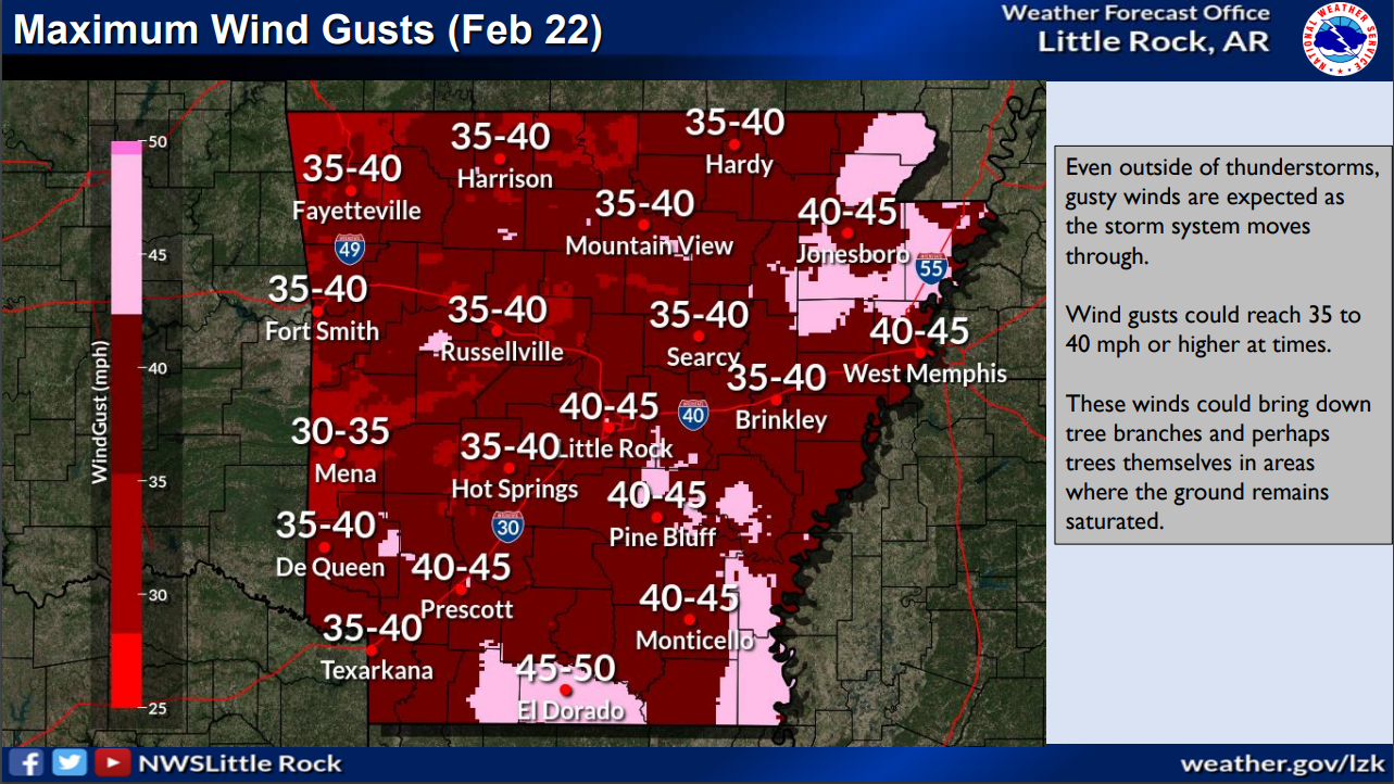
Storms and gusty winds expected for Arkansas on Wednesday

A system will be moving through the region on Wednesday which could bring a few strong storms to the area but the overall threat appears to be minimal. The greater concern may be the strong winds that will accompany the system outside of any thunderstorm activity.

Severe Weather Briefing for Arkansas from the National Weather Service in Little Rock

[TODAY] A strong storm system will be approaching the region through today, providing the next widespread thunderstorm chances on Thursday. In between now and then, a stalled boundary draped across the state will remain the focus for intermittent showers and thunderstorms today. 

[THURSDAY] Our next main concern for organized severe weather will set up on Thursday as a cold front moves across the state from west to east. All severe hazards will be possible including damaging winds, some hail, and a few tornadoes. 

[ADDITIONAL HAZARDS] Heavy to excessive rainfall and local flash flooding will remain a concern today and Thursday, given multiple rounds of precipitation have led to widespread saturated regions. 

Please click on the pic below to see the attached briefing for more information.