Arctic Air

Arctic Air blasts Arkansas this weekend; freezing rain and heavy rainfall early next week

From the National Weather Service in Little Rock

Arctic air is arriving from the Plains Friday morning. A gusty northwest wind will produce wind chill index values from zero to ten below zero in the northern two to three rows of counties in Arkansas. 

Below to much below normal temperatures will continue through the weekend. Saturday will be the coldest day, with lows in the single digits and teens and highs in the 20s and 30s. Minimum wind chill indices will be in the single digits above and below zero Friday night into Saturday morning. 

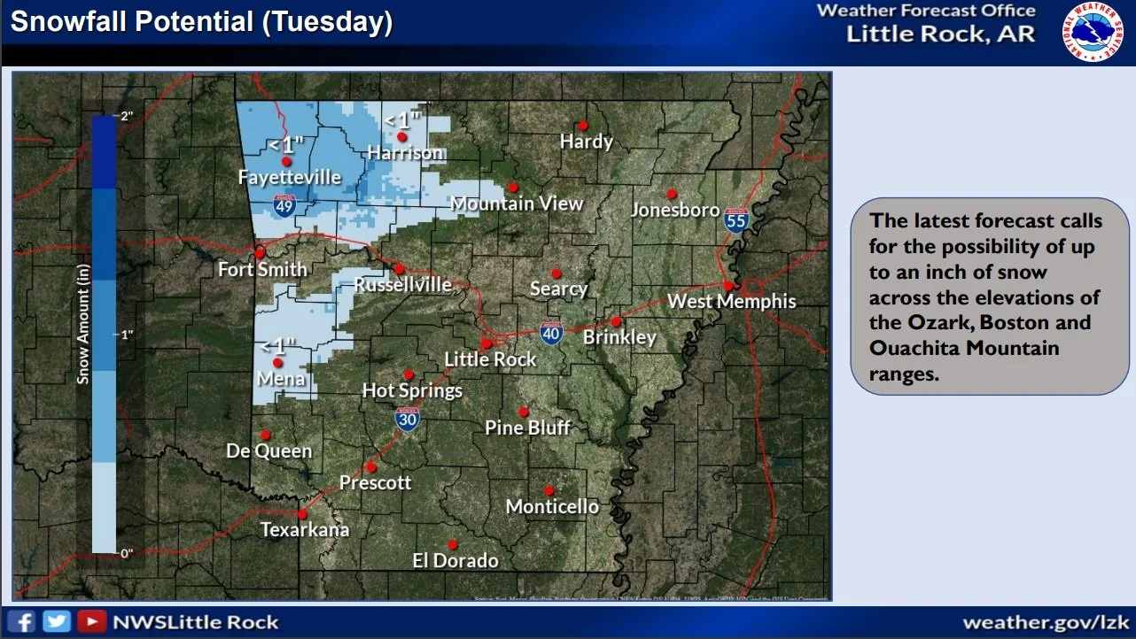
Late Sunday night and Monday, Arctic air will begin exiting to the east. Clouds and moisture will increase, with rain developing. Precipitation will likely start off as freezing rain, with the potential for at least a tenth of an inch of ice in northern/western sections of the state. 

Rain will continue through at least Thursday. The forecast calls for one to more than three inches of rain across the region, with the heaviest amounts over the southern counties.

Another arctic air blast coming our way; Winter Weather Briefing from the NWS

Pockets of very light freezing rain are expected in portions of central and eastern Arkansas this morning. A light glaze of ice is possible in places. Amounts will be on the order of a trace to a few hundredths of an inch.  A Winter Weather Advisory has been posted. 

Another round of Arctic air will arrive Thursday night/Friday, and will stay with us through the weekend. The magnitude of this surge of cold air will not rival what we have experienced lately, but temperatures will be well below normal. Saturday will be the coldest day with temperatures starting to recover Sunday. 

As Arctic air exits to the east early next week, moisture will increase across the Plains. Rain will likely develop across the region on Monday, and may begin as a period of freezing rain in the morning. At this time, it appears some icing is possible, especially in western sections of the state.

Winter Weather Briefing and road conditions for Arkansas from the National Weather Service and IDriveArkansas

  • Snow has let up over most of the northern half of Arkansas. Another round of snow and sleet is expected to develop across the southern half of the state, with additional accumulations of 0.5” to 1” possible through this afternoon.

  • Travel impacts (including hazardous road conditions and reduced visibilities) will be possible where snowfall or sleet occurs, including major throughways, bridges/overpasses, and rural roads.

  • Bitterly cold temperatures, much below climatological averages, are expected to continue through at least Tuesday night and into Wednesday morning. Temperatures have fallen to single digits to below-zero in portions of northern Arkansas, and daily high temperatures will likely not rise above freezing again until Wednesday afternoon (at the earliest) for most areas of the state.

  • Morning minimum wind chill values will remain below zero degrees over a large portion of Arkansas, and persist at hazardous levels through at least Wednesday morning due to abundant Arctic air and breezy conditions.

  • A brief reprieve from below-normal temperatures will resume on Wednesday and Thursday, and another shot of Arctic air is forecast to move into the region by late this week, bringing more belownormal temps through this coming weekend.

Winter storm moving into Arkansas this weekend

The National Weather Service in Little Rock advises:

  • As colder air moves in this morning, rain will continue transitioning to light snow across west/northwest Arkansas, with less than an inch of accumulation at most locations.

  • Beginning mid-morning, sustained wind speeds between 25 and 30 mph will be common across the state, with gusts over 45 mph.

  • Precipitation will exit the state by Friday evening, with winds settling down by late Friday night.

  • By late Saturday, Arctic air will begin to surge into the region from the northwest. This will result in below to much below average temperatures through early next week. Once cold air is in place, it appears that wintry precipitation will become more likely Sunday night into Monday. There is potential for warning criteria snow (several inches or more). Stay tuned for specifics.

Arctic air means extra care for pets

HARRISBURG, Ark. — When arctic air arrives, pets need extra care, said Craig Allen, Poinsett County extension staff chair for the University of Arkansas System Division of Agriculture.

The National Weather Service at Little Rock said Wednesday that “by the weekend/early next week, Arctic air will surge into the region from the northwest. This will result in below to much below-average temperatures.”

Lows in Little Rock were expected to fall into the single digits by Monday night, with the forecast high on Tuesday being 27 degrees, the weather service said.

Boston the dog sits in the snow. Taken February 2021. (U of A System Division of Agriculture photo by Kerry Rodtnick)

“Outdoor pets need a sheltered place that is well bedded with dry straw, shavings, blanket strips or other insulating material that traps warm air,” he said. “Check it often and change it whenever it gets wet.

“Be sure to have adequate food and water available. Heated water bowls are handy to have,” Allen said.

Owners need to limit the amount of time indoor pets are exposed to extreme temperatures. Short-haired dog breeds such as greyhounds, Dobermans, boxers, Chihuahuas and miniature breeds “shouldn’t go outside without a sweater or coat, except for short periods to relieve themselves,” Allen said.

Cats, even outdoor cats, will seek warm spots, and sometimes in dangerous ways.

“Cats left outdoors will often crawl into a warm car engine compartment to get warm,” Allen said. “The cat can be seriously injured or killed by the fan blade or fan belt the next time the car is started. Be sure to check for cats or other animals that might have sought out the warmth of your car.”

Schnauzer gets some playtime in the snow in Fayetteville. Taken Jan. 5, 2024. (U of A System Division of Agriculture still courtesy Kwan Seo).

Preparing vehicles for cold weather service can mean adding or changing antifreeze. Pets can be drawn to spilled antifreeze because of its taste, but antifreeze with ethylene glycol is toxic to pets even in very small quantities.

“Promptly clean up any spills,” he said. “Antifreeze is attractive to pets and can be deadly, even in very small amounts.”

To learn about extension programs in Arkansas, contact your local Cooperative Extension Service agent or visit www.uaex.uada.edu. Follow us on X and Instagram at @AR_Extension. To learn more about Division of Agriculture research, visit the Arkansas Agricultural Experiment Station website: https://aaes.uada.edu. Follow on X at @ArkAgResearch. To learn more about the Division of Agriculture, visit https://uada.edu/. Follow us on X at @AgInArk.

Arkansas Weather Briefing from the National Weather Service in Little Rock

There are two storm systems that will impact Arkansas this week. One system will be here today and Tuesday (January 8-9), with another system arriving from the west later Thursday and Friday (January 11-12).

The former system will be primarily a rainmaker, and there will be some rumbles of thunder in places. One to two inches of rain are in the forecast. Any severe weather will remain along the Gulf Coast. As colder air wraps around the departing storm, some light snow could occur over parts of northwest Arkansas (mainly the Boston and Ozark Mountains) on Tuesday. Wind gusts of 30 to 40 mph will be common Monday and Tuesday. The higher terrain over northwest Arkansas could have gusts up to 50 mph. 

The latter system will be much like the former system; mostly rain is in the forecast. At this point, there is a potential for severe storms in southern Arkansas. Light snow will likely follow the system in northern sections of the state. There will be a lot of wind as well. 

By the weekend/early next week, Arctic air will surge into the region from the northwest. This will result in below to much below average temperatures. 

Once cold air is in place, it appears that wintry precipitation will become more likely early next week as storm systems continue arriving from the west/southwest.

Arctic front blasting the state on Thursday

An arctic front will blast through the state on Thursday with very cold air and gusty winds accompanying the boundary. 

Wind chill warnings and advisories have been issued along with a winter weather advisory across the north for several inches of snow. Strong winds will blow this snow about as it will be dry and powdery with low moisture content.

Arctic Air to Blast Arkansas This Week

The latest guidance is showing the front moving through earlier than previous thinking and crossing the Mississippi River by mid to late afternoon.

We are still expecting a blast of bitterly cold air behind the front with dangerous wind chills by Friday morning. The arctic air will settle over the state through Christmas with only some moderation expected. The winds will slacken on Friday as the system pulls away but the cold will remain. There is currently a wind chill watch in effect for the north with wind chill advisories or warnings likely across most if not all of the state with time.

Finally there could be some snow across mainly the north and northwest with an inch or two possible but most areas will see less than that as the system will be moving very quickly, moisture is limited and the window for accumulating snow is relatively small.