Below Freezing

Another arctic air blast coming our way; Winter Weather Briefing from the NWS

Pockets of very light freezing rain are expected in portions of central and eastern Arkansas this morning. A light glaze of ice is possible in places. Amounts will be on the order of a trace to a few hundredths of an inch.  A Winter Weather Advisory has been posted. 

Another round of Arctic air will arrive Thursday night/Friday, and will stay with us through the weekend. The magnitude of this surge of cold air will not rival what we have experienced lately, but temperatures will be well below normal. Saturday will be the coldest day with temperatures starting to recover Sunday. 

As Arctic air exits to the east early next week, moisture will increase across the Plains. Rain will likely develop across the region on Monday, and may begin as a period of freezing rain in the morning. At this time, it appears some icing is possible, especially in western sections of the state.

Arkansas Weather Briefing from the National Weather Service in Little Rock

There are two storm systems that will impact Arkansas this week. One system will be here today and Tuesday (January 8-9), with another system arriving from the west later Thursday and Friday (January 11-12).

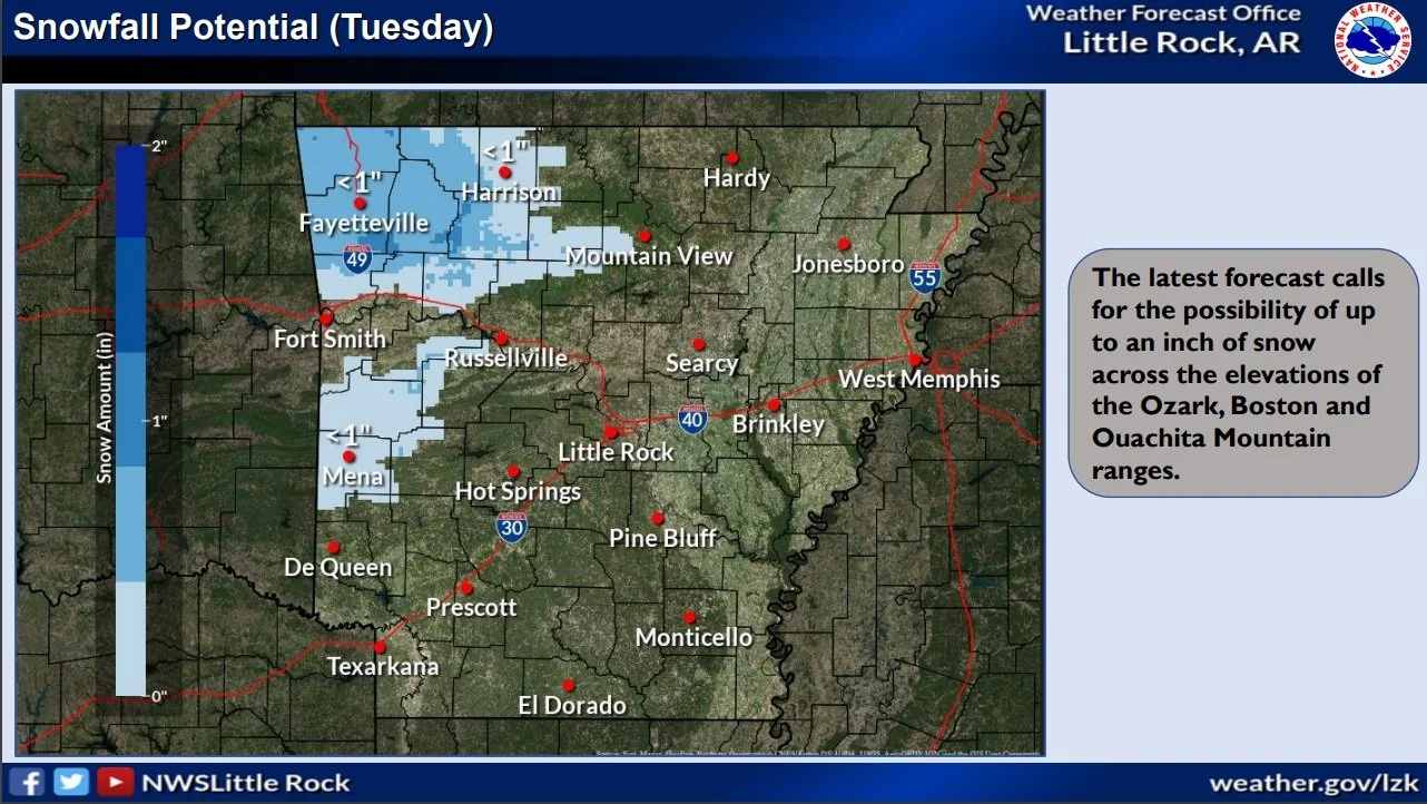
The former system will be primarily a rainmaker, and there will be some rumbles of thunder in places. One to two inches of rain are in the forecast. Any severe weather will remain along the Gulf Coast. As colder air wraps around the departing storm, some light snow could occur over parts of northwest Arkansas (mainly the Boston and Ozark Mountains) on Tuesday. Wind gusts of 30 to 40 mph will be common Monday and Tuesday. The higher terrain over northwest Arkansas could have gusts up to 50 mph. 

The latter system will be much like the former system; mostly rain is in the forecast. At this point, there is a potential for severe storms in southern Arkansas. Light snow will likely follow the system in northern sections of the state. There will be a lot of wind as well. 

By the weekend/early next week, Arctic air will surge into the region from the northwest. This will result in below to much below average temperatures. 

Once cold air is in place, it appears that wintry precipitation will become more likely early next week as storm systems continue arriving from the west/southwest.

Winter storm and ice warnings in parts of Arkansas; travel is affected

...WINTER WINTER ADVISORY IN SOUTHWEST ARKANSAS HAS BEEN UPGRADED TO A WINTER STORM WARNING NOW IN EFFECT UNTIL 9 AM CST WEDNESDAY...

* WHAT...Significant icing. Additional ice accumulations of near
  one quarter of an inch.

* WHERE...Sevier, Howard, Hempstead and Nevada Counties.

* WHEN...Until 9 AM CST Wednesday.

* IMPACTS...Bridges and overpasses could become slick resulting in
  travel impacts this morning. Those impacts will continue through
  the day and especially into the overnight hours. Power outages
  and tree damage are likely due to the ice.

 PRECAUTIONARY/PREPAREDNESS ACTIONS...

If you must travel, keep an extra flashlight, food, and water in
your vehicle in case of an emergency. Prepare for possible power
outages.

The latest road conditions for the state you are calling from can
be obtained by calling 5 1 1, or in Arkansas see the idrivearkansas.com website.

Cold Weather May Impact Cattle Breeding this Spring

by George Jared

Record cold weather just prior to the start of spring could have a significant impact on the number of cattle produced during 2021. Cattle breeding experts with the University of Arkansas System Division of Agriculture are urging cattle producers to test the fertility of their bulls before the spring breeding season.

Charles Looney, professor of cattle improvement for the Division of Agriculture, said the unusual freeze event the state experienced in mid-February may have resulted in infertility in bulls that did not have adequate shelter.

https://talkbusiness.net/2021/03/cold-weather-may-impact-cattle-breeding-this-spring/

USDAfarm-732x330.jpg