

[WHAT] Winter weather conditions, including accumulating snow, mixed sleet and snow, and some freezing rain is forecast to spread across the state today through Wednesday, resulting in widespread travel impacts.
[WHEN] Winter precipitation will begin across northwest Arkansas later this morning, and expand towards central to southern Arkansas by this afternoon to evening, and persist through Wednesday morning (February 19).
[WHERE] Significant accumulating snowfall is expected across the northern third of the state, with mixed precipitation including sleet/snow and freezing rain over the southern two-thirds of the state.
[ADDITIONAL INFO]
Winter Storm Warnings are in effect for portions of northern and central Arkansas due to heavy snow and sleet. This is where forecast confidence is highest for impactful accumulations.
Winter Weather Advisories are in effect for the remainder of the state where lesser snow, sleet, and freezing rain totals are expected.
Hazardous cold is forecast by Wednesday morning with single digit to negative morning wind chill values forecast through Friday morning. Cold Weather Advisories are in effect for a large portion of the state tonight, and additional cold weather headlines will likely be needed through Friday morning.
Winter Weather Briefing from the National Weather Service in Little Rock
Snow appears most likely well to the north of Arkansas
A cold rain is favored across much of the southern half of the state and nearby areas
There is an increasing concern that areas along the AR/MO border, including the higher terrain in Arkansas, will have to deal with freezing rain or mixed precipitation

Winter weather headed for Arkansas; briefing attached

Winter Storm Warnings continue across the vast majority of Arkansas through the Thursday-Friday (January 9-10) timeframe. A Winter Weather Advisory is posted in the far southeast. The Winter Storm Warning area currently encompasses where the highest confidence for impactful conditions exist.
NWS issues a Winter Storm Warning for southern and central Arkansas

Portions of the Winter Storm Watch have been upgraded to a Winter Storm Warning, valid through the Thursday-Friday (January 9-10) timeframe. The Winter Storm Warning area currently encompasses where the highest confidence for impactful conditions exist. Changes and expansions to the watch and warning areas are still possible and should be expected!
WHAT HAS CHANGED: Portions of the Winter Storm Watch have been upgraded to a Winter Storm Warning, mainly including the southern half of the state (south of I-40). This largely includes where confidence of impactful snowfall is currently highest. Expansions of the warning are still possible!
WHAT WE KNOW: A strong storm system is forecast to impact Arkansas Thursday morning through Friday evening bringing heavy snow across much of the state. Greatest confidence for impacts will be across west-central to central Arkansas.
WHAT WE DON’T KNOW: Exact placement of greatest snow amounts, and where locally greater totals could occur due to banding. Where snow may change over to sleet, freezing rain, or just rain near the Louisiana border. Expect changes and refinement to the forecast!
Winter Weather Advisory with freezing rain expected from the NWS

Arctic air remains entrenched across Arkansas, but will start to exit to the east later tonight and Monday. Clouds and moisture will continue to increase tonight with rain developing. The precipitation will be in the form of freezing rain through Monday morning before temperatures warm and it transitions over to just regular rain.
Before this change occurs, a quarter of an inch of ice or more could fall over parts of western and northern Arkansas where ice storm warnings are in effect. Outside of the warning area, winter weather advisories are in effect for some ice accumulation.
Additional rounds of rain are expected through the week with several inches of rain possible, especially over the south and southeast.
Winter Weather Advisory
URGENT - WINTER WEATHER MESSAGE
National Weather Service Shreveport LA
227 PM CST Sun Jan 21 2024

ARZ050-051-059>061-OKZ077-221100-
/O.CON.KSHV.WW.Y.0002.240122T0400Z-240122T1500Z/
Sevier-Howard-Little River-Hempstead-Nevada-McCurtain-
Including the cities of De Queen, Nashville, Mineral Springs,
Dierks, Ashdown, Hope, Prescott, Idabel, and Broken Bow
227 PM CST Sun Jan 21 2024

...WINTER WEATHER ADVISORY REMAINS IN EFFECT FROM 10 PM THIS
EVENING TO 9 AM CST MONDAY...

* WHAT...Freezing rain expected. Total ice accumulations of around
  one tenth of an inch, except isolated higher amounts between a
  tenth to a quarter of an inch in the higher elevations of
  Northern McCurtain, Northern Sevier, and Northern Howard
  Counties.

* WHERE...Portions of southwest Arkansas and southeast Oklahoma.

* WHEN...From 10 PM this evening to 9 AM CST Monday.

* IMPACTS...Difficult travel conditions are possible, especially
  on bridges and overpasses. The hazardous conditions could
  impact the overnight and morning commute.

PRECAUTIONARY/PREPAREDNESS ACTIONS...

Slow down and use caution while traveling. Prepare for possible
power outages.

The latest road conditions for the state you are calling from can
be obtained by calling 5 1 1.Winter Weather Briefing and road conditions for Arkansas from the National Weather Service and IDriveArkansas

Snow has let up over most of the northern half of Arkansas. Another round of snow and sleet is expected to develop across the southern half of the state, with additional accumulations of 0.5” to 1” possible through this afternoon.
Travel impacts (including hazardous road conditions and reduced visibilities) will be possible where snowfall or sleet occurs, including major throughways, bridges/overpasses, and rural roads.
Bitterly cold temperatures, much below climatological averages, are expected to continue through at least Tuesday night and into Wednesday morning. Temperatures have fallen to single digits to below-zero in portions of northern Arkansas, and daily high temperatures will likely not rise above freezing again until Wednesday afternoon (at the earliest) for most areas of the state.
Morning minimum wind chill values will remain below zero degrees over a large portion of Arkansas, and persist at hazardous levels through at least Wednesday morning due to abundant Arctic air and breezy conditions.
A brief reprieve from below-normal temperatures will resume on Wednesday and Thursday, and another shot of Arctic air is forecast to move into the region by late this week, bringing more belownormal temps through this coming weekend.
Winter storm moving into Arkansas this weekend

The National Weather Service in Little Rock advises:
As colder air moves in this morning, rain will continue transitioning to light snow across west/northwest Arkansas, with less than an inch of accumulation at most locations.
Beginning mid-morning, sustained wind speeds between 25 and 30 mph will be common across the state, with gusts over 45 mph.
Precipitation will exit the state by Friday evening, with winds settling down by late Friday night.
By late Saturday, Arctic air will begin to surge into the region from the northwest. This will result in below to much below average temperatures through early next week. Once cold air is in place, it appears that wintry precipitation will become more likely Sunday night into Monday. There is potential for warning criteria snow (several inches or more). Stay tuned for specifics.
National Weather Service in Little Rock Weather Briefing

We are monitoring two potentially impactful weather events through early next week. The first, this Thursday and Friday, will bring another round of rain, storms, and winter weather. After a brief lull over much of the weekend, an Arctic front will make its way into the southern states, bringing well-below-average temperatures and potential for snow across much of the state.
The storm system Thursday/Friday will bring a half inch to an inch and a half of rain, with locally more than two inches. The highest rainfall totals are expected from central into northeast sections of the state. Isolated severe storms may occur in central and southern Arkansas. As colder air follows the system on Friday, rain will transition to light snow across the north/west (Ozark and Ouachita Mountains), with less than an inch of accumulation at most locations. Beginning Friday late morning, sustained wind speeds are forecast between 20 and 30 mph with gusts over 40 mph. Precipitation will exit the state by Friday evening, with winds settling down by late Friday night.
By the weekend/early next week, Arctic air will surge into the region from the northwest. This will result in below to much below average temperatures. Once cold air is in place, it appears that wintry precipitation will become more likely Sunday night into Monday. There is a potential for heavy warning criteria snow (several inches). Stay tuned for specifics.
Arkansas Weather Briefing from the National Weather Service in Little Rock
There are two storm systems that will impact Arkansas this week. One system will be here today and Tuesday (January 8-9), with another system arriving from the west later Thursday and Friday (January 11-12).
The former system will be primarily a rainmaker, and there will be some rumbles of thunder in places. One to two inches of rain are in the forecast. Any severe weather will remain along the Gulf Coast. As colder air wraps around the departing storm, some light snow could occur over parts of northwest Arkansas (mainly the Boston and Ozark Mountains) on Tuesday. Wind gusts of 30 to 40 mph will be common Monday and Tuesday. The higher terrain over northwest Arkansas could have gusts up to 50 mph.
The latter system will be much like the former system; mostly rain is in the forecast. At this point, there is a potential for severe storms in southern Arkansas. Light snow will likely follow the system in northern sections of the state. There will be a lot of wind as well.
By the weekend/early next week, Arctic air will surge into the region from the northwest. This will result in below to much below average temperatures.
Once cold air is in place, it appears that wintry precipitation will become more likely early next week as storm systems continue arriving from the west/southwest.

Snow in the forecast for parts of Arkansas Friday and Friday night

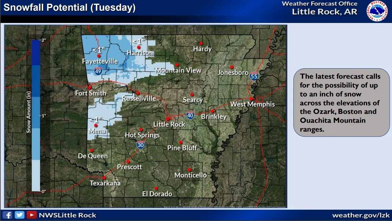
The next weather system is expected to move across Arkansas on Friday bringing with it light amounts of wintry weather across the higher terrain of the Ozark/Boston Mountains, and potentially the higher terrain of the Ouachitas. If the snowfall does materialize, amounts of 1 to 2 inches with higher amounts near 3 inches could fall over the highest elevations of the Boston Mountains.
Temperatures on Friday will barely support wintry weather reaching the ground, with temperatures near freezing to above freezing, thus impacts should be limited to elevated objects such as trees, vehicles, and possible bridges and overpasses.
This system is expected to be minor, with minor impacts to those higher elevation locations. Continue to monitor the forecast from your local forecast office.
Winter weather advisories, winter storm warnings, and ice storm warnings across Arkansas; ice affecting travel, trees, and power lines

If you must travel, keep an extra flashlight, food, and water in
your vehicle in case of an emergency. Prepare for possible power
outages.

The latest road conditions for the state you are calling from can
be obtained by calling 5 1 1.

Winter storm and ice warnings in parts of Arkansas; travel is affected

...WINTER WINTER ADVISORY IN SOUTHWEST ARKANSAS HAS BEEN UPGRADED TO A WINTER STORM WARNING NOW IN EFFECT UNTIL 9 AM CST WEDNESDAY...

* WHAT...Significant icing. Additional ice accumulations of near
  one quarter of an inch.

* WHERE...Sevier, Howard, Hempstead and Nevada Counties.

* WHEN...Until 9 AM CST Wednesday.

* IMPACTS...Bridges and overpasses could become slick resulting in
  travel impacts this morning. Those impacts will continue through
  the day and especially into the overnight hours. Power outages
  and tree damage are likely due to the ice.

 PRECAUTIONARY/PREPAREDNESS ACTIONS...

If you must travel, keep an extra flashlight, food, and water in
your vehicle in case of an emergency. Prepare for possible power
outages.

The latest road conditions for the state you are calling from can
be obtained by calling 5 1 1, or in Arkansas see the idrivearkansas.com website.
National Weather Service in Little Rock warns of accumulating ice in Arkansas; Winter weather briefing attached
Accumulating ice is possible across much of the state, but the highest totals (a quarter inch or more) will likely be in the central third of the state. An ice storm warning is in effect for those areas with surrounding areas in a winter weather advisory.

Winter Weather Advisories are in effect for portions of northern, west-central, and southern Arkansas. An Ice Storm Warning is in effect for portions of central and northeastern Arkansas.
• As temperatures slowly drop at or below freezing, two systems are expected to pull moisture into the state. The first system is expected by this afternoon bringing the chance of freezing rain/sleet to portions of northern and central Arkansas. The second system (the main freezing rain producer) is expected to move in Tuesday afternoon, affecting a larger portion of the state.
Winter weather on the way to Arkansas; winter storm warning and winter weather advisory issued

Here is the latest update for the Winter Storm expected Tuesday through Wednesday.
We've slightly increased snowfall amounts across western and northwestern Arkansas.
Also, the Winter Storm Warning and Winter Weather Advisory have been issued.
Changes to snow amounts/coverage of accumulation are still possible, but overall confidence for impactful snowfall is high.
Arctic Cold Front Heading to Arkansas

Dangerous cold air is coming to Arkansas this week.
Areas of light snow are expected on Thursday, especially from northern into central Arkansas. Advisory criteria accumulations are possible. There could be some travel issues as temperatures turn sharply colder.
Arctic air will be in place at the end of the week, with well below normal temperatures in the forecast. Breezy northwest winds will create wind chill index values below zero across much of the region Thursday night and Friday morning. Temperatures will fall below zero in parts of the Ozark Mountains Friday morning, with readings below freezing statewide during the day.
National Weather Service Winter Weather Briefing for Arkansas

We are still on track to seeing some wintry weather over parts of northern and western Arkansas late today and tonight. Rain will mix with and eventually changeover to all snow by early this evening, across the Ozark and Ouachita Mountains. Snow accumulations of one to two inches remain possible, especially in the highest elevations.
While this will be a quick hitting event, there may be minor travel impacts. Roads in some areas may become snow/slush covered, with icy patches on bridges and overpasses.
Winter Weather Briefing for Arkansas
Click on pic above for the complete Winter Weather Briefing
Winter Weather Briefing from the National Weather Service in Little Rock; Saturday's wind chill values expected in the single digits and teens for the state

Click on pic above for the winter weather briefing.
Winter Weather on the way for Arkansas

Click on Pic Above for the latest Winter Weather Briefing for Arkansas
Ice Accumulations Expected With Winter Storm Warning in Arkansas

A winter storm with significant snow and ice accumulations is imminent! Additionally, a very cold Arctic air mass will move into the state late this week with minimum temperatures in the single digits to low 20s and wind chills in the single digits. - National Weather Service