

A strong cold front will surge through Arkansas from the Plains on Saturday. The front will trigger showers and thunderstorms.
There is a risk of severe thunderstorms on Saturday as the front plows into an unseasonably mild (springlike) and unstable environment across the state. Data currently indicates all modes of severe weather (including tornadoes, damaging winds, and hail) will be possible.
Cooler and more seasonal air will follow the front Saturday night and Sunday. Residual moisture may yield a few snowflakes in the Ozark Mountains before precipitation ends Sunday afternoon.
With An Additional 2 1/4 inches, Total Snow/Sleet Accumulation Was 9 3/4 Inches in De Queen

The Winter Storm Warning for Southwest Arkansas has expired and the National Weather Service says we can expect a slow warming trend for the next several days with high temperatures back up into the lower 60’s for the middle part of next week.
Snow, Bitter Cold Impact Livestock In Arkansas
By GEORGE JARED/ TALK BUSINESS & POLITICS
Single-digit wind chills, freezing water in pipes and troughs, and high snow loads on roofs are causing concerns for poultry and cattle operations, specialists from the University of Arkansas System Division of Agriculture said Monday.
The record-setting storm front that stretches from Texas to Maine has caused millions to lose power as snowfall totals and bitter cold ravage almost half the country, according to the National Weather Service.
Low temperatures reported Monday morning to the National Weather Service included minus five at Compton, zero at Lead Hill and two degrees at Gilbert. At noon Monday, the North Little Rock airport had 10.9 inches of snow, while Greers Ferry, Perryville and Vilonia all reported 11 inches of snow, according to the National Weather Service.
https://www.ualrpublicradio.org/post/snow-bitter-cold-impact-livestock-arkansas
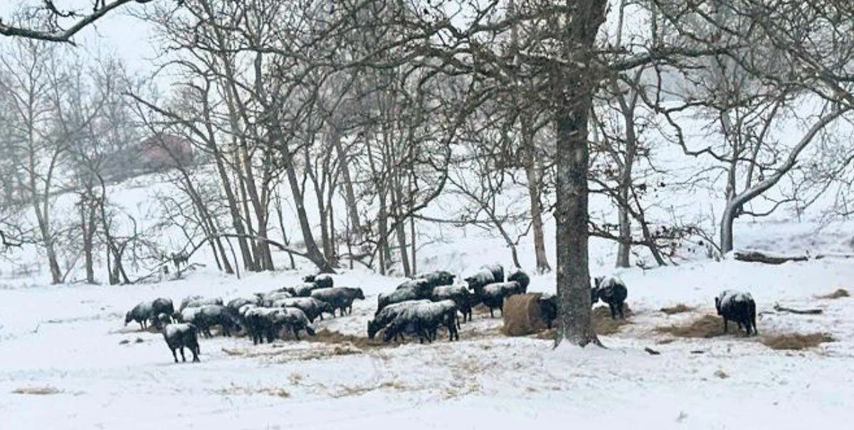
Cattle in the snow at a farm in Carroll County, Arkansas.
CREDIT ARKANSAS FARM BUREAU
Hard Freeze for Tonight and More Snow Expected in Forecast from the National Weather Service
...HARD FREEZE WARNING REMAINS IN EFFECT UNTIL 6 AM CST TUESDAY...

* WHAT...Sub-freezing temperatures to fall into the single digits
  tonight.

* WHERE...Portions of north central and northwest Louisiana, south
  central and southwest Arkansas, and portions of east Texas.

* WHEN...Through 6 AM CST Tuesday.

* IMPACTS...Hard freeze conditions will kill crops, other
  sensitive vegetation and damage unprotected outdoor plumbing.

PRECAUTIONARY/PREPAREDNESS ACTIONS...

Take steps now to protect tender plants from the cold. To prevent
freezing and possible bursting of outdoor water pipes they should
be wrapped, drained, or allowed to drip slowly. Those that have
in-ground sprinkler systems should drain them and cover above-
ground pipes to protect them from freezing.
Tonight
Partly cloudy, with a low around 1. Northwest wind around 5 mph becoming calm in the evening.
Tuesday
Increasing clouds, with a high near 26. Wind chill values as low as 1. Calm wind becoming southeast around 5 mph in the afternoon.
Tuesday Night
A chance of snow showers before midnight, then snow and sleet likely. Cloudy, with a low around 19. Wind chill values as low as 11. East wind around 5 mph. Chance of precipitation is 70%.
Wednesday
Snow showers before noon, then snow showers, freezing rain, and sleet. The snow could be heavy at times. High near 29. Northeast wind 5 to 10 mph. Chance of precipitation is 100%.
Wednesday Night
Snow showers, freezing rain, and sleet likely before midnight, then a chance of snow showers. Cloudy, with a low around 23. Chance of precipitation is 60%.
Thursday
A 40 percent chance of snow showers, mainly before noon. Mostly cloudy, with a high near 33.
Thursday Night
Partly cloudy, with a low around 10.
Friday
Sunny, with a high near 38.
Friday Night
Partly cloudy, with a low around 18.
Saturday
Mostly sunny, with a high near 46.
Saturday Night
Mostly cloudy, with a low around 35.
Sunday
Mostly cloudy, with a high near 53.
Winter Weather Advisory for SW AR, SE OK and NE TX Sunday Night and Monday
...Accumulating snowfall will be possible across portions of the
area this evening through Monday morning...

.A strong winter storm will be moving through the region today
and continue into Monday morning. Rain during the day today will
transition to all snow or a wintry mix this evening and continue
into early monday morning. Accumulating snow will be possible
across the entire area with the greatest amounts across portions
of north central and northwest Louisiana, south central Arkansas
and east and northeast Texas.

ARZ050-051-059>061-070>072-LAZ020-022-OKZ077-TXZ096-097-108>112-
101700-
/O.NEW.KSHV.WW.Y.0001.210110T2000Z-210111T1400Z/
Sevier-Howard-Little River-Hempstead-Nevada-Miller-Lafayette-
Columbia-Grant-La Salle-McCurtain-Red River-Bowie-Franklin-Titus-
Camp-Morris-Cass-
Including the cities of De Queen, Nashville, Mineral Springs,
Dierks, Ashdown, Hope, Prescott, Texarkana, Stamps, Lewisville,
Bradley, Magnolia, Colfax, Montgomery, Dry Prong, Jena, Midway,
Olla, Idabel, Broken Bow, Clarksville, Bogata, Mount Vernon,
Mount Pleasant, Pittsburg, Daingerfield, Lone Star, Naples,
Omaha, Atlanta, Linden, Hughes Springs, and Queen City
255 AM CST Sun Jan 10 2021

...WINTER WEATHER ADVISORY IN EFFECT FROM 2 PM THIS AFTERNOON TO
8 AM CST MONDAY...

* WHAT...Mixed precipitation expected. Total snow accumulations of
  up to two inches possible.

* WHERE...Portions of north central Louisiana, southeast
  Oklahoma, southwest Arkansas and northeast Texas.

* WHEN...From 2 PM this afternoon to 8 AM CST Monday.

* IMPACTS...Difficult travel conditions are possible as roads may
  become slick, especially on bridges and elevated roadways. The
  hazardous conditions could impact the morning commute.

PRECAUTIONARY/PREPAREDNESS ACTIONS...

Slow down and use caution while traveling.

The latest road conditions for the state you are calling from can
be obtained by calling 5 1 1.
A strong winter storm will move into the region this afternoon
bringing widespread snow to the area during the evening through
Monday morning. A Winter Storm Warning is in effect for this time
period. Snow accumulations 2 to 4 inches will be possible through
Monday morning. The potential for icing on bridges, overpasses
and elevated roadways will be of most concern by the Monday
morning commute as the air temperature will be below freezing.
Conditions will improve across the area by Monday afternoon.
Highs temperatures will approach near 40 degrees allowing for some
melting to occur. Areas that get the higher amounts of snow will
possibly see some refreezing Monday night into Tuesday morning.
Exercise caution on Tuesday morning due to the potential for slick
spots, especially on bridges and overpasses.