Little River News

National Weather Service Eclipse Weather Briefing for Arkansas

A large storm system will be over the southwest United States during the day of the eclipse. Ahead of the system, a south to southwest flow will bring increasing moisture and the possibility of clouds/chances of showers throughout the path of totality in Arkansas.  

Important to Remember: Despite vast improvements of weather models in recent years, any information over more than a few days of a specific time is subject to change. Forecast details will be fine tuned as additional data is received up to the time of the eclipse.   

Weekly Update from State Representative DeAnn Vaught

The total solar eclipse on April 8, 2024, has captured the attention of Arkansans and visitors alike. The path of totality will stretch over 100 miles across The Natural State, extending from the southwest to the northeast. In some locations, lucky observers will experience over four minutes of total darkness. It is expected that 53 of Arkansas' 75 counties will fall within the path of totality, including major cities like Little Rock, Hot Springs, Texarkana, Conway, and Jonesboro. 

With the potential to mark the largest tourism event in state history, Arkansas agencies are leaving no stone unturned in their preparations. The Arkansas Department of Transportation (ARDOT) has strategically scheduled a "construction holiday" from April 4 to April 9, ensuring smooth travel with no lane closures or active construction zones. Collaborating closely with the trucking industry, ARDOT aims to minimize the presence of oversized trucks on the roads, enhancing safety for all travelers.

Meanwhile, the Arkansas Department of Education is harnessing the eclipse as a teachable moment, integrating it into science lessons and distributing one million eclipse glasses to libraries statewide. This proactive approach not only fosters scientific curiosity but also promotes safe viewing practices among students and the general public.

In the realm of healthcare, the Arkansas Department of Health stands vigilant, leveraging its trauma communication system to swiftly address any emergencies. Collaborating closely with hospitals and first responders, the agency is working to ensure prompt access to medical facilities, should the need arise. Emphasizing the paramount importance of eye safety, the department underscores the necessity of approved solar viewing glasses, cautioning against direct sun-gazing without proper protection.

As anticipation mounts, Arkansans are encouraged to prepare themselves with essential supplies, including water, food, medications, and first aid kits, in readiness for potential service delays.

For those eager to join in the festivities, a wealth of information on local events and safety guidelines awaits at Arkansas.com/eclipse.

Severe Weather Briefing from the National Weather Service

There will be a brief window for severe weather Monday afternoon and evening over the south and southeast parts of the state. While there will be a lot of wind energy with this system, instability is low which will keep the severe threat limited. 

Windy conditions are expected to develop before the actual system arrives and some parts of the state may see some locally heavy rain.

  • We continue to monitor a strong cold front that will be moving across the state Monday into Monday evening. Sustained winds of 20 to 30 mph are expected with higher gusts possible outside of any thunderstorm activity.

  • Strong gusty winds remain the primary threat with storms on Monday. While the tornado threat is minimal, it is not zero.

  • The greatest overlap of severe thunderstorm ingredients will lie over southern and southeastern Arkansas Monday afternoon and evening. While there is a tremendous amount of wind energy with this system, instability is limited.

  • Widespread rain is expected before the actual cold front arrives which will further decrease the chance of widespread severe weather.

  • In addition to severe weather, localized heavy rainfall is possible, primarily over the western half of the state. Some localized flash flooding issues may arise as a result.

Weekly Update from State Representative DeAnn Vaught

This week, the Arkansas Legislative Council and the council subcommittees convened at the Capitol.

The council approved the permanent payment rules for Educational Freedom Accounts. Educational Freedom Accounts may be used by eligible families to cover private school tuition, fees, uniforms, and some other required expenses. First-time kindergarteners, students enrolled in “D” or “F” rated schools, students with a disability, current or former foster care students, students experiencing homelessness, or students whose parents are active-duty military, veterans, law enforcement or first responders will be eligible to use the accounts in the 2024-2025 school year. All public school students will be eligible in the 2025-2026 school year.

The council also approved an emergency rule from the Department of Finance and Administration that requires Arkansans to list their gender on their driver’s license.  The rule states the gender must match what is listed on the person’s birth certificate, passport, or identification document from the U.S. Department of Homeland Security.

The ALC Game and Fish/State Police Subcommittee continued its study on possession and open-carry laws concerning firearms this week. The subcommittee will begin hearing recommendations regarding these laws at its next meeting on Monday, March 25. The meetings are open to the public. You can find the agenda and a link to sign up to comment atwww.arkleg.state.ar.us.

The latest revenue report presented to the council shows gross general revenues have decreased by $113 million or 2% below what was collected last year. Meanwhile, unemployment in the state remains steady at 3.7% in Arkansas for the third consecutive month.

As a reminder, the legislature will convene for a Fiscal Session on April 10. We will continue to update you on the latest developments from the Capitol.

Severe Weather Briefing for Arkansas on Thursday from the National Weather Service

Scattered strong to severe thunderstorms are expected to develop in eastern Oklahoma this afternoon and move into Arkansas later this afternoon and early evening. These storms will be capable of all severe hazards through later tonight.

The main changes with this briefing include:

-- An expansion of the "Enhanced Risk" area towards northeastern Arkansas

-- The introduction of a 10% Tornado Risk Area over northwestern to northern central Arkansas

Large and damaging hail remains the primary threat with storms today, though all modes of severe weather will be possible today and tonight.

Click on the attached briefing below for more specific forecast information.

Weather Outlook for Arkansas on Thursday from the National Weather Service

A storm system will arrive from the Plains on Thursday and bring showers and thunderstorms to Arkansas Thursday into Thursday night.  

Heavy rainfall, flash flooding, and severe weather will be possible for portions of Arkansas beginning Thursday

Isolated to scattered severe thunderstorms could occur across the western two-thirds of Arkansas Thursday and Thursday night. The main concern will be large hail and damaging winds, however a tornado can not be ruled out. The environment will be most unstable (warm/moist) in the southwest part of the state, and that is where damaging winds, large hail, and a few tornadoes are most favorable.

National Weather Service Severe Weather Briefing

A storm system arriving from the southern Plains will bring additional showers and thunderstorms to Arkansas today and tonight.

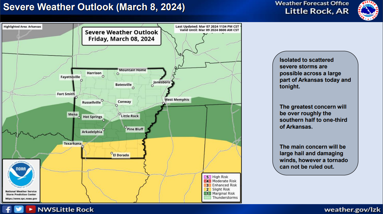
  • Isolated to scattered severe storms could occur across the southern half to one-third of Arkansas today and tonight. The main concern will be large hail and damaging winds, however a tornado can not be ruled out. The environment will be most unstable (warm/moist) toward the Gulf Coast, and that is where damaging winds/a few tornadoes are most favorable.

  • The forecast calls for an additional one-quarter of an inch to over one inch of rain across the state today and tonight. Locally heavier amounts are possible in the south and southeast portions of the state. Any flash flooding should be localized.

  • Sub-freezing temperatures possible Sunday morning over portions of Arkansas.

Severe Weather Briefing from the National Weather Service

  • Isolated severe storms could occur over western Arkansas today. Large hail would be the main concern.

  • Isolated to scattered severe storms could occur across mainly the southern half of Arkansas on Friday. The main concerns will be large hail and damaging winds; however, a tornado or two can not be ruled out. The environment will be most unstable (warm/moist) toward the Gulf Coast, and that is where damaging winds and a few tornadoes are most favored.

  • The forecast calls for one to two inches of rain across much of the state, with locally heavier amounts possible in the north. Any flash flooding should be localized.

Weekly Update from State Representative DeAnn Vaught

From classrooms to healthcare, the state budget has a direct impact on our daily lives. Weeks before the legislative session begins, the General Assembly reviews the state’s current fiscal position and budget requests for the upcoming fiscal year. Budget hearings this year will begin on March 6 and are expected to continue through March 8. These hearings will be held in the MAC building located directly behind the Capitol. The hearings are open to the public and will be live-streamed on our website.

The Department of Finance and Administration will present the Governor’s recommendation for a balanced budget on the first day of budget hearings which will begin at 9 am. After the balanced budget proposal is presented, the Joint Budget Committee will then begin hearing budget requests from state agencies. Historically, the two largest categories of funding are education and human services. Higher education, public safety, and health are also top budget priorities.

The most recent general revenue report released showed net available general revenue at 5.6% below levels from one year ago. After seven months into the fiscal year, net available revenue is above forecast by $231.2 million or 6.0 percent. All of the information gathered during these hearings will help in drafting appropriation bills. Members can begin pre-filing bills on March 11.

The Arkansas General Assembly will convene for the 2024 Fiscal Session at noon on April 10. Fiscal Sessions began after Arkansas voters approved Amendment 86 in 2008. This will be the 8th Fiscal Session held in state history. Fiscal Sessions are held in February in years in which the primary elections are held in May. The Fiscal Sessions begin in April in years, like this year, in which primary elections are held in March. Fiscal Sessions are limited to 30 days unless ¾ of the General Assembly agrees to a one-time extension not to exceed 15 days. You can watch the meetings and find the daily agendas at www.arkansashouse.org.

Cooperative Extension Service launches new University Center website

By Rebekah Hall
U of A System Division of Agriculture

LITTLE ROCK — The University of Arkansas System Division of Agriculture Center for Rural Resilience and Workforce Development has launched a new website detailing the resources and services offered through its newest program, designed to support economic and workforce development across Arkansas.

NEW ONLINE RESOURCE — The University of Arkansas System Division of Agriculture Center for Rural Resilience and Workforce Development has a new website with information about the resources and services it offers, including training and technical assistance, applied research and an interactive Development District map. (U.S. Economic Development Administration graphic.) 

In November 2023, the U.S. Economic Development Administration, or EDA, awarded a $650,000, five-year grant to the Cooperative Extension Service’s department of Community, Professional and Economic Development to establish and operate a University Center. Rather than a physical location, the EDA University Center program is a resource serving the state’s economic development ecosystem, with a particular focus on rural marginalized communities, including Hispanic and Marshallese communities.

The Center’s new website outlines information about the program and its services, including training and technical assistance, applied research and annual research findings reports. The website also features an interactive map of Arkansas’s eight EDA-funded Development Districts, which serve all 75 counties.

“The Development Districts offer incredible services to their communities, such as grant writing, planning and economic development projects, and we want to make sure anyone in their community can find their district and connect with them,” said Brandon L. Mathews, extension program manager for the University Center.

Mathews said that Heartland Forward, one of the strategic partners of the University Center, led the creation of the Development District map.

“The interactive map is just one of many visualizations we hope to build with the Center,” said Rodrigo Ramirez-Perez, research analyst for Heartland Forward. “Our goal is to make data accessible and usable throughout the project, while also uplifting the Development Districts and the incredible work they do for the state.”

Over the next five years, more information and resources will be added to the University Center website. Those resources include Labor Market Observatories, which will be dashboards that provide important data on workforce metrics for each of the eight districts.

Mathews said the Center will also offer a newsletter that highlights funding opportunities, EDA activities and updates, community and economic development district events, workshops and tools for workforce development. Those interested can sign up for this resource at the FACT Sheet Newsletter Sign-up.

To learn more about the Center for Rural Resilience and Workforce Development, contact Hunter Goodman at hgoodman@uada.edu or Mathews at bmathews@uada.edu.

To learn about extension programs in Arkansas, contact your local Cooperative Extension Service agent or visit www.uaex.uada.edu. Follow us on X and Instagram at @AR_Extension. To learn more about Division of Agriculture research, visit the Arkansas Agricultural Experiment Station website: https://aaes.uada.edu. Follow on X at @ArkAgResearch. To learn more about the Division of Agriculture, visit https://uada.edu/. Follow us on X at @AgInArk. 

Aerial Lineman Training Center at UA Cossatot Holds Grand Opening in De Queen

The University of Arkansas Cossatot hosted a grand opening event at its Aerial Lineman Training Center in De Queen on Thursday, February 1. UAC Chancellor Dr. Steve Cole welcomed the crowd, including the current aerial lineman class and community and industry leaders. Dr. Cole explained the program’s history and the extensive efforts invested in its establishment, saying, “Short-term programs that give people wonderful skills and employees that want to hire them after four weeks of training, that a huge part of the future of Arkansas.” In addition, Dr. Cole announced the college had written a multi-million dollar grant to establish a fiber optic network engineering program at UA Cossatot. In Cole’s words, “We think this would be a perfect way to augment what we are already doing with the Aerial Lineman program.”

Among the guest speakers was Stephanie Isaacs, Director of the Arkansas Office of Skills Development, who discussed the partnership with UA Cossatot and her office’s role in procuring essential trucks and equipment for the program.

Rick Giesler, Division Director of Compliance with Ervin Cable Construction, told the audience, “Programs like this are instrumental in us being able to make our industry safer, to make our industry a better place, to drive better wages so these young people can have a home.”

Scottie Morris, co-creator of the curriculum with Luke Ervin of Ervin Cable Construction and Jeff Tollett of Southwest Arkansas Electric Cooperative, talked about his role in starting the program. He said the day after he retired, he received a call from Dr. Cole, who asked him to come on board to help the college train aerial linemen. Morris agreed, and a former parking lot near the UAC Amphitheater was picked as the site for the pole-training yard. In Morris’ closing remarks, he said, “I believe a lot of good things will come out of this lot.”

Representatives from Bridgepoint Communications, Systems Services Broadband, Ervin Cable Construction, Four States Fiber Internet, NEA Construction, and Desert Media Group were among the attendees. Notable figures such as State Representative Deann Vaught, Kyla Waters, Arkansas Community Colleges Center for Workforce Director, and Kamelle Gomez from the Arkansas State Broadband Office attended.

The Aerial Lineman Program at UA Cossatot is currently under the direction of Dennis Davis. He has over 43 years of experience in the telecommunications industry and utilizes a combination of classroom and hands-on field experiences co-designed with employers to equip students with the knowledge, skills, and abilities they seek when hiring an aerial lineman to install, maintain, and repair telecommunications infrastructure.

UA Cossatot is an Arkansas Fiber Academy training location. The Arkansas Fiber Academy is a partnership between Arkansas Community Colleges, the Arkansas Office of Skills Development, and the Arkansas State Broadband Office.

To find out more about the UA Cossatot Aerial Lineman Training program, visit www.cccua.edu or contact Continuing Education Services at ContinuingEducation@cccua.edu or (870) 584-1178.

Winter Weather Advisory with freezing rain expected from the NWS

Arctic air remains entrenched across Arkansas, but will start to exit to the east later tonight and Monday. Clouds and moisture will continue to increase tonight with rain developing. The precipitation will be in the form of freezing rain through Monday morning before temperatures warm and it transitions over to just regular rain.

Before this change occurs, a quarter of an inch of ice or more could fall over parts of western and  northern Arkansas where ice storm warnings are in effect. Outside of the warning area, winter weather advisories are in effect for some ice accumulation.

Additional rounds of rain are expected through the week with several inches of rain possible, especially over the south and southeast.

Winter Weather Advisory

URGENT - WINTER WEATHER MESSAGE
National Weather Service Shreveport LA
227 PM CST Sun Jan 21 2024

ARZ050-051-059>061-OKZ077-221100-
/O.CON.KSHV.WW.Y.0002.240122T0400Z-240122T1500Z/
Sevier-Howard-Little River-Hempstead-Nevada-McCurtain-
Including the cities of De Queen, Nashville, Mineral Springs,
Dierks, Ashdown, Hope, Prescott, Idabel, and Broken Bow
227 PM CST Sun Jan 21 2024

...WINTER WEATHER ADVISORY REMAINS IN EFFECT FROM 10 PM THIS
EVENING TO 9 AM CST MONDAY...

* WHAT...Freezing rain expected. Total ice accumulations of around
  one tenth of an inch, except isolated higher amounts between a
  tenth to a quarter of an inch in the higher elevations of
  Northern McCurtain, Northern Sevier, and Northern Howard
  Counties.

* WHERE...Portions of southwest Arkansas and southeast Oklahoma.

* WHEN...From 10 PM this evening to 9 AM CST Monday.

* IMPACTS...Difficult travel conditions are possible, especially
  on bridges and overpasses. The hazardous conditions could
  impact the overnight and morning commute.

PRECAUTIONARY/PREPAREDNESS ACTIONS...

Slow down and use caution while traveling. Prepare for possible
power outages.

The latest road conditions for the state you are calling from can
be obtained by calling 5 1 1.

Weekly Update from State Representative DeAnn Vaught

Public education stands as the primary expenditure within state government. This month, the House and Senate Education Committees began working on the Educational Adequacy Study. This study will serve as a recommendation to the legislature to determine funding for the 2025-2026 and 2026-2027 school years.

This in-depth process involves assessing the entirety of public education to ensure equal opportunities for students, covering aspects from teacher salaries to technological requirements. Arkansas employs a specific formula, the matrix, to calculate per-student funding, which is set to increase from $7,618 to $7,771 for the 2024-2025 school year.

The committees will later examine facilities funding and partnership programs in February, followed by a review of teacher-related aspects such as recruitment, retention, salaries, and professional development in June.

The culmination of this study results in a final report due on November 1, serving as a crucial guide for funding decisions in the subsequent year.

At the most recent meeting, committee members reviewed student achievement data. Reports revealed that in 2022, 30% of Arkansas 4th-grade students scored proficient or above in reading, slightly below the national average of 32%. Additionally, 28% of Arkansas 4th-grade students and 35% nationally scored proficient or above in math.

The House and Senate Education Committees approved an emergency rule to implement literacy tutoring grants and High Impact Learning Grants.

The literacy grant program is designed to help struggling readers in grades K-3. It will allow families to invoice up to $500 per year for tutoring services.

The second program will provide a limited amount of funding for schools to spend on tutoring services during the school day.

The proposed rule now goes before the Arkansas Legislative Council Executive Committee, scheduled to meet on January 18.

The House and Senate Education Committees will convene again on February 5 and February 6, with live-streamed and recorded meetings accessible at www.arkansashouse.org.

Arctic Air blasts Arkansas this weekend; freezing rain and heavy rainfall early next week

From the National Weather Service in Little Rock

Arctic air is arriving from the Plains Friday morning. A gusty northwest wind will produce wind chill index values from zero to ten below zero in the northern two to three rows of counties in Arkansas. 

Below to much below normal temperatures will continue through the weekend. Saturday will be the coldest day, with lows in the single digits and teens and highs in the 20s and 30s. Minimum wind chill indices will be in the single digits above and below zero Friday night into Saturday morning. 

Late Sunday night and Monday, Arctic air will begin exiting to the east. Clouds and moisture will increase, with rain developing. Precipitation will likely start off as freezing rain, with the potential for at least a tenth of an inch of ice in northern/western sections of the state. 

Rain will continue through at least Thursday. The forecast calls for one to more than three inches of rain across the region, with the heaviest amounts over the southern counties.

Another arctic air blast coming our way; Winter Weather Briefing from the NWS

Pockets of very light freezing rain are expected in portions of central and eastern Arkansas this morning. A light glaze of ice is possible in places. Amounts will be on the order of a trace to a few hundredths of an inch.  A Winter Weather Advisory has been posted. 

Another round of Arctic air will arrive Thursday night/Friday, and will stay with us through the weekend. The magnitude of this surge of cold air will not rival what we have experienced lately, but temperatures will be well below normal. Saturday will be the coldest day with temperatures starting to recover Sunday. 

As Arctic air exits to the east early next week, moisture will increase across the Plains. Rain will likely develop across the region on Monday, and may begin as a period of freezing rain in the morning. At this time, it appears some icing is possible, especially in western sections of the state.

Could be some freezing rain Thursday morning; NWS Weather Briefing for Arkansas

Temperatures are expected to climb above freezing both Wednesday and Thursday helping with the melting process. Whatever melts during the day will freeze again at night leading to some travel impacts.

A weak weather system may bring a little freezing rain to parts of central and east Arkansas early Thursday but only a thin glaze is expected at this time.Temperatures will warm above freezing  later on Thursday, minimal impacts are expected.

Following the brief warming period, another bout of Arctic air is expected to move into the forecast area, bringing back bitter cold overnight temperatures through this coming weekend.

Weekly Update from State Representative DeAnn Vaught

This week, the Arkansas Legislative Council Game and Fish/State Police Subcommittee held a meeting to discuss concealed carry laws in Arkansas.

This meeting was part of a series of meetings held as part of the Arkansas Firearms and Concealed Carry Laws Study. The purpose of the study is to ultimately simplify gun laws in the state and clarify where and when it is legal to carry firearms.

Subcommittee members reviewed a summary of various state statutes addressing concealed carry.  There are more than 30 sections of Arkansas Code addressing concealed carry laws.

The Arkansas Attorney General’s office also presented a series of recommendations for future legislation to expand gun rights and clarify several existing laws. 

The next meeting of the Arkansas Game and Fish/State Police Subcommittee will be held on Wednesday, January 24 at 1:30 p.m. in the MAC building located behind the State Capitol. The January 24 meeting will specifically address concealed carry regulations as promulgated by Arkansas State Police.

On March 11 and March 18 the subcommittee will focus on possession and open carry.

Later in the year, the subcommittee will hear from law enforcement and other armed officers as well as local governments and the business community.

We’ve posted the schedule for the additional hearings at arkansashouse.org.

The public is welcome to attend the meetings and there will be time for public comment.

The subcommittee will submit a final report to the ALC Executive Subcommittee by October 1, 2024. The Executive Subcommittee will then submit a report and possibly begin drafting legislation by the end of this year.

Winter Storm Warning for Arkansas

Winter weather in the form of snowfall and a few days of brutally cold temperatures will soon be upon us. Make needed preparations immediately and have a way to get the latest weather info. Do not wait until the first snowflakes fall or you feel the temperature is cold enough to be a concern, at that point it is too late to begin thinking about preparing. Act now and be ahead of the storm!

Widespread accumulating snow is expected to overspread the state Sunday through Monday. Over a large part of Arkansas, amounts of 2 to 3 inches or less are expected. There could be a narrow corridor of heavier snow which could produce 4 to 6 plus inches. As it stands now, this band is positioned over east-central Arkansas, but could still shift south with time. There is a chance some of the precipitation over southern Arkansas could mix with sleet, if this scenario plays out, actual amounts will be lower. Changes to forecast snow totals are still possible.

Low temperatures are expected to drop overnight and remain well below average for the next several days. Low temperatures are expected to be in the teens to near zero degrees across the state with wind chills feeling much colder.

...WIND CHILL ADVISORY REMAINS IN EFFECT UNTIL NOON CST TODAY...
...WINTER STORM WARNING REMAINS IN EFFECT FROM NOON TODAY TO 6 PM
CST MONDAY...

* WHAT...For the Wind Chill Advisory, very cold wind chills
  expected. Wind chills as low as 5 below zero. For the Winter
  Storm Warning, heavy mixed precipitation expected. Total snow
  accumulations of 1 to 2 inches and ice accumulations of a light
  glaze with locally higher amounts possible.

* WHERE...Portions of southwest Arkansas and southeast Oklahoma.

* WHEN...For the Wind Chill Advisory, from 9 PM this evening to
  noon CST Sunday. For the Winter Storm Warning, from noon
  Sunday to 6 PM CST Monday.

* IMPACTS...Travel could be very difficult. The hazardous
  conditions could impact the morning or evening commute. The
  cold wind chills could result in hypothermia if precautions
  are not taken.

PRECAUTIONARY/PREPAREDNESS ACTIONS...

Use caution while traveling outside. Wear appropriate clothing, a
hat, and gloves.

If you must travel, keep an extra flashlight, food, and water in
your vehicle in case of an emergency.

The latest road conditions for the state you are calling from can
be obtained by calling 5 1 1.

Winter storm moving into Arkansas this weekend

The National Weather Service in Little Rock advises:

  • As colder air moves in this morning, rain will continue transitioning to light snow across west/northwest Arkansas, with less than an inch of accumulation at most locations.

  • Beginning mid-morning, sustained wind speeds between 25 and 30 mph will be common across the state, with gusts over 45 mph.

  • Precipitation will exit the state by Friday evening, with winds settling down by late Friday night.

  • By late Saturday, Arctic air will begin to surge into the region from the northwest. This will result in below to much below average temperatures through early next week. Once cold air is in place, it appears that wintry precipitation will become more likely Sunday night into Monday. There is potential for warning criteria snow (several inches or more). Stay tuned for specifics.

National Weather Service in Little Rock Weather Briefing

We are monitoring two potentially impactful weather events through early next week. The first, this Thursday and Friday, will bring another round of rain, storms, and winter weather. After a brief lull over much of the weekend, an Arctic front will make its way into the southern states, bringing well-below-average temperatures and potential for snow across much of the state. 

The storm system Thursday/Friday will bring a half inch to an inch and a half of rain, with locally more than two inches. The highest rainfall totals are expected from central into northeast sections of the state. Isolated severe storms may occur in central and southern Arkansas. As colder air follows the system on Friday, rain will transition to light snow across the north/west (Ozark and Ouachita Mountains), with less than an inch of accumulation at most locations. Beginning Friday late morning, sustained wind speeds are forecast between 20 and 30 mph with gusts over 40 mph. Precipitation will exit the state by Friday evening, with winds settling down by late Friday night.

By the weekend/early next week, Arctic air will surge into the region from the northwest. This will result in below to much below average temperatures. Once cold air is in place, it appears that wintry precipitation will become more likely Sunday night into Monday. There is a potential for heavy warning criteria snow (several inches). Stay tuned for specifics.